Click here for more info on on SMS!

KIND

INDIANAPOLIS INTL
INDIANAPOLIS
IN
Time Zone: Eastern
Lat: N 3943.0
Long: W 08617.7
Elev: 796
Var: +05
Longest Runway: 11200
Clr Del: 128.75
Dept. ATIS: 134.25
Arr. ATIS: 134.25
Ground: 121.8/121.9
Tower: 120.9

FBO & Flight Services info for KIND

FBOs: Update your Fuel Prices

  click here  
Indianapolis is best known for hosting the three largest single-day sporting events in the world: the Indy 500 in May, the Brickyard 400 in July and Red Bull Moto GP in August. This Midwestern city is a hotbed for industries ranging from retail to manufacturing. Whether business or pleasure, Signature-Indianapolis offers the best in executive aviation services.
Ph: 800-333-6464 Fax: 317-248-4924 Freq: 129.72WebsiteE-Mail
                     
Service
Jet
100LL
SAF
MoGas
Fuel Avail: PRIST +$0.06/gal.
Full7.667.85    Last Update: 04/22/2024 15:26

Self        
Misc. Info: Volume discounts on sliding scale (Fuel Up Program), AvTrip Points offeredAddress: 6390 TURNER DRIVE   INDIANAPOLIS, INDIANA 46241
Million Air Indianapolis is committed to providing a first-class destination for private air travelers. Our facility is designed and personnel are trained to provide quick responses, elegant amenities, superior services, and tastefully appointed accommodations for both business and leisure private jet travelers while providing outstanding services to our customers.
Ph: 800-365-6734 Fax: 317-243-3081 Freq: 130.57WebsiteE-Mail
                   
Service
Jet
100LL
SAF
MoGas
Fuel Avail: 24/7/365 PRIST+$0.10/gal
Full7.758.30    Last Update: 04/15/2024 12:29

Self        
Misc. Info: Address: 6921 PIERSON DRIVE   INDIANAPOLIS, IN 46241

ASOSPh: 317-241-0348
-
-
 
If you are an FBO, call 1-203-262-1700 to update your info or email: FltPlan.Advertising@garmin.com
Advertise your FBO on FltPlan.com
FBOs at nearby airports who want your business:
KHFY


  click here  
Enjoy the convenience of flying into downtown Indianapolis' closest airport! Less than 2 miles from interstate access and 15 minutes from downtown, we offer a 5100' runway, heated hangar accommodations, on-site courtesy & rental cars, crew lounge, quiet room, flight planning, & an updated terminal!
Ph: 317-881-0887 WebsiteE-MailFax: 317-865-2771 Freq: 123.0

Runway & Approach Info for KIND
Rwy
Length
Land Dist**
Approach*
  Rwy
Length
Land Dist**
Approach*
05L
11200x150  11200'          
ILS/DME
 111.75 - 049°  
  
23R
  11200x150  11200'          
ILS/DME
 111.75 - 229°  
05R
10000x150  10000'          
ILS/DME
 111.15 - 049°  
  
23L
  10000x150  10000'          
ILS/DME
 111.15 - 229°  
14
7278x150  7278'          
ILS
 110.50 - 139°  
  
32
  7278x150  7278'          
ILS
 110.50 - 319°  
 * only ILS, LOC, LDA, and SDF approaches to a specific runway are shown
** For any Declared Landing Distance Available, please see A/FD or Approach plates
Runway Weight Capability (lbs.) Help
Runway IDSingle WheelDouble WheelDouble Tandem WheelDual Double Wheel
05L/23R145,000300,000550,000N/A
05R/23L145,000300,000550,000N/A
14/32145,000300,000550,000N/A
These numbers are Advisory and are not limits.   The Airport Manager should have more accurate Weight Limits
Approach Charts
Approaches    
Current Weather/Notams
Customs Information Send updates to Support@FltPlan.com
Phone 317-241-9780
Fax 317-248-4174

Comments Mon-Fri 0800-1700 *2 hrs advance notice required *Call prior to 1700 on preceeding weekday. indianapolisatu@cbp.dhs.gov
Database effective 05/16/2024
Airport Diagram of KIND
Airport Diagram might not be current.

Facility Name: INDIANAPOLIS INTL
City Name: INDIANAPOLIS
County: MARION
State abbrev: IN
State Name: INDIANA
   
Ownership: PUBLICLY OWNED
Use: OPEN TO THE PUBLIC
Owner's Name: INDIANAPOLIS AIRPORT AUTH
Address: 7800 COL. H. WEIR COOK MEMORIAL DR.
 INDIANAPOLIS, IN 46241
Owner's Phone: 317-487-9594
  
Manager's Name: MARIO RODRIGUEZ
Address: 7800 COL. H. WEIR COOK MEMORIAL DR.
 INDIANAPOLIS, IN 46241
Phone: 317-487-9594
   
FAA Region: GREAT LAKES
FAA Field Office: CHI


Sunrise / Sunset times for INDIANAPOLIS INTL

DateSunriseSunset
04/22/24 Monday6:5720:31
04/23/24 Tuesday6:5520:32
04/24/24 Wednesday6:5420:33
04/25/24 Thursday6:5220:34
04/26/24 Friday6:5120:35
04/27/24 Saturday6:5020:36
04/28/24 Sunday6:4920:37
04/29/24 Monday6:4720:38
04/30/24 Tuesday6:4620:39
05/01/24 Wednesday6:4520:40
05/02/24 Thursday6:4420:41
05/03/24 Friday6:4220:42
05/04/24 Saturday6:4120:43
05/05/24 Sunday6:4020:44

Airport Facilities

Airport Attendance ScheduleCONTINUOUS
Airport Status OPERATIONAL (This Status can change at any time - please check NOTAMS)
Airport Lighting Schedule
Airport Storage AvailableTie Downs
Extra Services AvailableCargo Handling
Wind IndicatorYES - (lighted)
Control TowerYES
CTAF Frequency
Unicom Frequency122.950
Rotating Beacon ColorWG
Segmented CircleNO
Landing Fee

Airport Inspection Data

Airport InspectedFEDERAL - performed by FAA AIRPORTS FIELD PERSONNEL
Inspection Date09/19/2023

Airport Services

Type of Fuel AvailableGrade 100LL, JET A (freeze point -40C), JET A-1 (icing inhibitor, freeze point -50C)
Airframe Repair ServiceMAJOR
Power Plant Repair ServiceMAJOR

Geographic Data

LatitudeN3943.0
LongitudeW08617.7 (ESTIMATED)
Arpt Elevation796ft (SURVEYED)
Magnetic Variation05W
7 miles SWof INDIANAPOLIS
Traffic Pattern Altitude
Sectional ChartST LOUIS

Aircraft Data

Operations (Reported)YearlyAvg. Daily
General Aviation Transient 1660946
General Aviation Local 00
Air Taxi 47744131
Commerical 128293351
Commuter 00
Military 9883
Aircraft based on Field
General Aviation Singles 52
General Aviation Multi 11
Jet Aircraft 31
General Aviation Helicopters 1
Military Aircraft 0
Gliders 0
Ultralights 0

FAA Services

FSS on field NO
FSS tie-in TERRE HAUTE
FSS Phone 1-800-WX-BRIEF
Who issues Notams IND
Notam D service at airport YES
ARTCC Name INDIANAPOLIS

Federal Status

Airport CertificationAIRPORT RECEIVING SCHEDULED AIR CARRIER SERVICE FROM CARRIERS CERTIFICATED BY THE CIVIL AERONAUTICS BOARD
Aircraft Rescue & Firefighting IndexAIRPORT HAS A CERTIFICATE UNDER CFR PART 139
Airport of EntryNo
Custom Landing RightsYES
Joint Civil/MilitaryNo
Military Landing rightsYES

Federal Agreements

NATIONAL PLAN OF INTEGRATED AIRPORT SYSTEMS (NPIAS)
GRANT AGREEMENTS UNDER FAAP/ADAP/AIP
SURPLUS PROPERTY AGREEMENT UNDER PUBLIC LAW 289
ASSURANCES PURSUANT TO TITLE VI, CIVIL RIGHTS ACT OF 1964
AGREEMENT UNDER DLAND OR DCLA HAS EXPIRED.

Remarks

PRIM STUDENT TGL NOT PMTD.
TWY V IS NOT AVBL FOR ACR OPS.
LARGE FLOCKS OF BIRDS ON & INVOF ARPT.
NOISE ABATEMENT PROCEDURES IN EFFECT CTC ARPT MGR.
BE ALERT TO CLOSE PROXIMITY OF RWY 14/32 TO NORTHEAST RAMP.
TWY H RUNS CONTIGUOUS AT NORTHEAST RAMP.
Airport Communications & Frequencies:
ATIS Frequencies:   Hours(local) of Operation: CONTINUOUS
134.25
INDY Tower Frequencies:   Hours(local) of operation: CONTINUOUS   
120.9
257.8
INDY Ground Frequencies:
121.8
121.9
Clearance Delivery Frequencies:
128.75
257.8
Pre-Taxi Clearance Frequencies:
128.75
Emergency Frequencies:
121.5
243.0
Unicom Frequency:
122.950
INDIANAPOLIS Primary Approach Frequencies:   Hours(local) of operation: CONTINUOUS   
124.65 ;WEST OF ACTIVE RWY
127.15 ;EAST OF ACTIVE RWY
128.175
317.8
INDIANAPOLIS Primary Departure Frequencies:   Hours(local) of operation: CONTINUOUS   
119.05 ;WEST
124.95 ;EAST
317.8
Class C Frequencies:
124.65 ;WEST OF ACTIVE RWY
124.95 ;EAST
127.15 ;EAST OF ACTIVE RWY
317.8
Runway Identifications
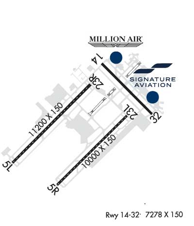
Runway Identification: 05L/23R
Length: 11200 ft
Width: 150 ft
Surface: CONCRETE-GOOD CONDITION
Edge lights: High Intensity

Treatment: GROOVED
Weight: PCN 103/R/B/W/T

 Runway: 05L   Runway: 23R
Mag heading: 50°Mag heading: 230°
Rwy Slope: .40% UpRwy Slope: -.40% Down
Approach: ILS/DMEApproach: ILS/DME
Pattern: Left TrafficPattern: Left Traffic
Markings: PRECISION INSTRUMENTMarkings: PRECISION INSTRUMENT
Marking Condition: GOODMarking Condition: GOOD
Arresting Dev: Arresting Dev:
Lat & Long: N3942.4  W08619.2Lat. & Long.: N3943.7  W08617.6
Elev: 738.0 ft. MSLElev: 782.9 ft. MSL
TCH: 74 ft. AGLTCH: 71 ft. AGL
Visual Glide Path: 3.00 degreesVisual Glide Path: 3.00 degrees
Displaced Threshold: NoDisplaced Threshold: No
Touchdown Zone: YESTouchdown Zone: YES
Touchdown Elev.: 747.3 feetTouchdown Elev.: 782.9 feet
Visual Glide Slope: 4-Light PAPI on LEFT side of RunwayVisual Glide Slope: 4-Light PAPI on LEFT side of Runway
RVR Equipment: TOUCHDOWN-MIDFIELD-ROLLOUTRVR Equipment: TOUCHDOWN-MIDFIELD-ROLLOUT
RVV Equipment: NORVV Equipment: NO
Approach Lights: ALSF2 - standard 2,400 foot high intensity approach lighting system with sequenced flashers, Category II or IIIApproach Lights: MALSR - 1,400 foot medium intensity approach lighting system with runway alignment indicator lights
REIL: NOREIL: NO
Centerline Lights: YESCenterline Lights: YES
Touchdown lights: YESTouchdown lights: NO
Runway Category: Precision Instrument RunwayRunway Category: Precision Instrument Runway
Declared Distances: TORA:11200' TODA:11200' ASDA:11200' LDA:11200'Declared Distances: TORA:11200' TODA:11200' ASDA:11200' LDA:11200'
Runway Identification: 05R/23L
Length: 10000 ft
Width: 150 ft
Surface: CONCRETE-GOOD CONDITION
Edge lights: High Intensity

Treatment: GROOVED
Weight: PCN 93 /R/B/W/T

 Runway: 05R   Runway: 23L
Mag heading: 50°Mag heading: 230°
Rwy Slope: -.01% DownRwy Slope: .01% Up
Approach: ILS/DMEApproach: ILS/DME
Pattern: Left TrafficPattern: Left Traffic
Markings: PRECISION INSTRUMENTMarkings: PRECISION INSTRUMENT
Marking Condition: GOODMarking Condition: GOOD
Arresting Dev: Arresting Dev:
Lat & Long: N3942.0  W08618.3Lat. & Long.: N3943.2  W08616.8
Elev: 788.8 ft. MSLElev: 787.6 ft. MSL
TCH: 70 ft. AGLTCH: 71 ft. AGL
Visual Glide Path: 3.00 degreesVisual Glide Path: 3.00 degrees
Displaced Threshold: NoDisplaced Threshold: No
Touchdown Zone: YESTouchdown Zone: YES
Touchdown Elev.: 790.7 feetTouchdown Elev.: 790.1 feet
Visual Glide Slope: 4-Light PAPI on LEFT side of RunwayVisual Glide Slope: 4-Light PAPI on LEFT side of Runway; PAPI UNUSBL BYD 7 DEGS LEFT OF CNTRLN.
RVR Equipment: TOUCHDOWN-MIDFIELD-ROLLOUTRVR Equipment: TOUCHDOWN-MIDFIELD-ROLLOUT
RVV Equipment: NORVV Equipment: NO
Approach Lights: ALSF2 - standard 2,400 foot high intensity approach lighting system with sequenced flashers, Category II or IIIApproach Lights: MALSR - 1,400 foot medium intensity approach lighting system with runway alignment indicator lights
REIL: NOREIL: NO
Centerline Lights: YESCenterline Lights: YES
Touchdown lights: YESTouchdown lights: NO
Runway Category: Precision Instrument RunwayRunway Category: Precision Instrument Runway
Declared Distances: TORA:10000' TODA:10000' ASDA:10000' LDA:10000'Declared Distances: TORA:10000' TODA:10000' ASDA:10000' LDA:10000'
Runway Identification: 14/32
Length: 7278 ft
Width: 150 ft
Surface: ASPHALT-GOOD CONDITION
Edge lights: High Intensity

Treatment: GROOVED
Weight: PCN 63 /F/C/W/T

 Runway: 14   Runway: 32
Mag heading: 140°Mag heading: 320°
Rwy Slope: -.07% DownRwy Slope: .07% Up
Approach: ILSApproach: ILS
Pattern: Left TrafficPattern: Left Traffic
Markings: PRECISION INSTRUMENTMarkings: PRECISION INSTRUMENT
Marking Condition: GOODMarking Condition: GOOD
Arresting Dev: Arresting Dev:
Lat & Long: N3944.1  W08617.3Lat. & Long.: N3943.2  W08616.2
Elev: 787.5 ft. MSLElev: 782.6 ft. MSL
TCH: 74 ft. AGLTCH: 73 ft. AGL
Visual Glide Path: 3.00 degreesVisual Glide Path: 3.00 degrees
Displaced Threshold: NoDisplaced Threshold: No
Touchdown Zone: YESTouchdown Zone: YES
Touchdown Elev.: 796.2 feetTouchdown Elev.: 792.9 feet
Visual Glide Slope: 4-Light PAPI on LEFT side of Runway; PAPI UNUSBL BYD 8 DEGS RIGHT OF CNTRLN.Visual Glide Slope: 4-Light PAPI on RIGHT side of Runway
RVR Equipment: TOUCHDOWN-ROLLOUTRVR Equipment: TOUCHDOWN-ROLLOUT
RVV Equipment: NORVV Equipment: YES
Approach Lights: MALSR - 1,400 foot medium intensity approach lighting system with runway alignment indicator lightsApproach Lights: MALSR - 1,400 foot medium intensity approach lighting system with runway alignment indicator lights
REIL: NOREIL: NO
Centerline Lights: NOCenterline Lights: NO
Touchdown lights: NOTouchdown lights: NO
Runway Category: Precision Instrument RunwayRunway Category: Precision Instrument Runway
Declared Distances: TORA:7278' TODA:7278' ASDA:7278' LDA:7278'Declared Distances: TORA:7278' TODA:7278' ASDA:7278' LDA:7278'
Obstructions: ANTObstructions:
Marked: NOT Marked/LightedMarked:
Clearance slope: 35:1Clearance slope: 50:1
Obstruction height: 61 feet AGLObstruction height:
Dist. from runway: 2370 feetDist. from runway:
Centerline offset: 756 left of centerlineCenterline offset:
Comments: Comments:
C:223/P: