Click here for more info on on SMS!

KIMT

FORD
IRON MNTN KINGSFORD
MI
Time Zone: Central
Lat: N 4549.1
Long: W 08806.9
Elev: 1182
Var: +02
Longest Runway: 6501
AWOS: 119.02
CTAF: 122.8

FBO & Flight Services info for KIMT

FBOs: Update your Fuel Prices

  click here  
KUBICK AVIATION SERVICES was started in 2002 to serve the general aviation community by offering quality services at a competitive price. We offer self service fuel, 24 hour pilots lounge, courtesy car (call ahead for availability), wireless internet, vending items, pilot supplies including navigation charts & various logbooks, tie-downs, hot coffee.
Ph: 906-779-5500 Fax: 906-779-5526 Freq: 122.80WebsiteE-Mail
                     
Service
Jet
100LL
SAF
MoGas
Fuel Avail: PRIST PREMIXED 24/7 ASSISTD SERVICE.
Full5.996.89    Last Update: 04/15/2024 10:13

Self  6.89    
Misc. Info: 250 Riverhills Rd. Kingsford, MI 49802Address: 250 RIVERHILLS ROAD,   KINGSFORD, MI 49802

SUPERIOR AVIATIONPh: 906-396-8888
-
-
Service
Jet
100LL
SAF
MoGas
Fuel Avail: ~~NO FUEL AVAILABLE, CHARTER FLIGHT & HANGAR SPACE
Full        Last Update: 04/23/2024 05:40:07  
Self        
ASOSPh: 906-774-1999
-
Freq: 119.02  
If you are an FBO, call 1-203-262-1700 to update your info or email: FltPlan.Advertising@garmin.com
Advertise your FBO on FltPlan.com

Runway & Approach Info for KIMT
Rwy
Length
Land Dist**
Approach*
  Rwy
Length
Land Dist**
Approach*
01
6501x150  6501'          
ILS
 111.50 - 009°  
  
19
  6501x150  6501'          
 
13
3808x75  3808'          
 
  
31
  3808x75  3808'          
 
 * only ILS, LOC, LDA, and SDF approaches to a specific runway are shown
** For any Declared Landing Distance Available, please see A/FD or Approach plates
Runway Weight Capability (lbs.) Help
Runway IDSingle WheelDouble WheelDouble Tandem WheelDual Double Wheel
01/19100,000100,000190,000N/A
13/3130,00050,00080,000N/A
These numbers are Advisory and are not limits.   The Airport Manager should have more accurate Weight Limits
Approach Charts
Approaches    
Current Weather/Notams
Customs Information Send updates to Support@FltPlan.com
Customs Not Available
Database effective 05/16/2024
Airport Diagram of KIMT
Airport Diagram might not be current.

Facility Name: FORD
City Name: IRON MOUNTAIN KINGSFORD
County: DICKINSON
State abbrev: MI
State Name: MICHIGAN
   
Ownership: PUBLICLY OWNED
Use: OPEN TO THE PUBLIC
Owner's Name: DICKINSON COUNTY
Address: COUNTY COURT HOUSE
 IRON MOUNTAIN, MI 49802
Owner's Phone: 906-774-2573
  
Manager's Name: TIM HOWEN
Address: FORD ARPT
 KINGSFORD, MI 49801
Phone: 906-774-4870; CELL 906-201-1866.
   
FAA Region: GREAT LAKES
FAA Field Office: DET
2005 - On Final for Runway 1 - By Mark S. Henry


Click here for full scale & interactive Sectional view of KIMT


Sunrise / Sunset times for FORD

DateSunriseSunset
04/22/24 Monday5:5319:49
04/23/24 Tuesday5:5119:51
04/24/24 Wednesday5:5019:52
04/25/24 Thursday5:4819:53
04/26/24 Friday5:4619:55
04/27/24 Saturday5:4519:56
04/28/24 Sunday5:4319:57
04/29/24 Monday5:4219:58
04/30/24 Tuesday5:4020:00
05/01/24 Wednesday5:3920:01
05/02/24 Thursday5:3720:02
05/03/24 Friday5:3620:04
05/04/24 Saturday5:3420:05
05/05/24 Sunday5:3320:06

Airport Facilities

Airport Attendance Schedule7 Days A Week 0530-2200
Airport Status OPERATIONAL (This Status can change at any time - please check NOTAMS)
Airport Lighting ScheduleACTVT MALSR RWY 01; REIL RWY 19 & 31; PAPI RWY 19 & 31; HIRL RWY 01/19; MIRL RWY 13/31 - CTAF.
Airport Storage AvailableTie Downs, Hanger
Extra Services AvailableAir Freight, Charter, Flight Instruction, Aircraft Rental
Wind IndicatorYES - (lighted)
Control TowerNO
CTAF Frequency122.800
Unicom Frequency122.800; UNICOM IREG MNTD.
Rotating Beacon ColorWG
Segmented CircleNO
Landing FeeYES

Airport Inspection Data

Airport InspectedFEDERAL - performed by FAA AIRPORTS FIELD PERSONNEL
Inspection Date06/28/2023

Airport Services

Type of Fuel AvailableGrade 100LL, JET A (freeze point -40C)
Airframe Repair ServiceMAJOR
Power Plant Repair ServiceMAJOR

Geographic Data

LatitudeN4549.1
LongitudeW08806.9 (ESTIMATED)
Arpt Elevation1182ft (SURVEYED)
Magnetic Variation02W
3 miles Wof IRON MOUNTAIN KINGSFORD
Traffic Pattern Altitude800; TPA FOR JET/TURBO-JET AND PROP ACFT OVER 12500LBS IS 1500' AGL.
Sectional ChartGREEN BAY

Aircraft Data

Operations (Reported)YearlyAvg. Daily
General Aviation Transient 7002
General Aviation Local 5001
Air Taxi 431612
Commerical 14404
Commuter 00
Military 100
Aircraft based on Field
General Aviation Singles 22
General Aviation Multi 8
Jet Aircraft 5
General Aviation Helicopters 1
Military Aircraft 0
Gliders 0
Ultralights 0

FAA Services

FSS on field NO
FSS tie-in GREEN BAY
FSS Phone 1-800-WX-BRIEF
Who issues Notams IMT
Notam D service at airport YES
ARTCC Name MINNEAPOLIS

Federal Status

Airport CertificationAIRPORT RECEIVING SCHEDULED AIR CARRIER SERVICE FROM CARRIERS CERTIFICATED BY THE CIVIL AERONAUTICS BOARD; ACR OPS GTR THAN 9 PAX SEATS NA IF NOT WI 15 MINS OF SKEDD ARR/DEP TIME EXC BY PRIOR CDN WITH AMGR & CFMN ARFF IS AVBL PRIOR TO TKOF/LDG.
Aircraft Rescue & Firefighting IndexAIRPORT HAS A CERTIFICATE UNDER CFR PART 139
Airport of EntryNo
Custom Landing RightsNo
Joint Civil/MilitaryNo
Military Landing rightsYES

Federal Agreements

NATIONAL PLAN OF INTEGRATED AIRPORT SYSTEMS (NPIAS)
GRANT AGREEMENTS UNDER FAAP/ADAP/AIP
ASSURANCES PURSUANT TO TITLE VI, CIVIL RIGHTS ACT OF 1964

Remarks

DEER, COYOTES, & BIRDS ON & INVOF ARPT.
48 HRS PPR FOR UNSKED ACR OPS GTR THAN 30 PAX SEATS - CALL AMGR CELL.
ARFF CREWS MNT CTAF/UNICOM DRG ALL ACR OPS.
SNOW REMOVAL CREWS MNT CTAF/UNICOM DRG ALL ACR OPS TO PRVD SFC COND RPRTS.
FLD CONDS UNMON OCT 15 THRU APR 1 BTN 2100-0600.
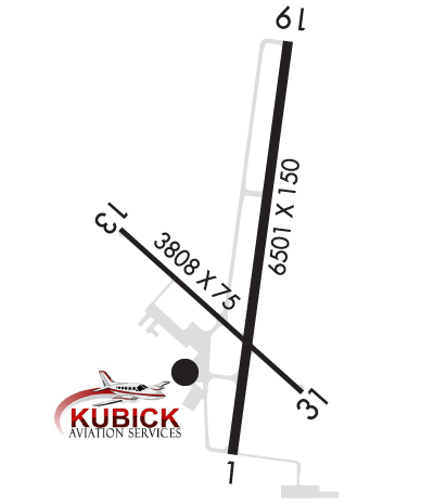
RWY 13/3 1 CLSD TO SKEDD ACR OPS GTR THAN 9 PAX SEATS OR UNSKED ACR OPS GTR THAN 30 PAX SEATS.
Airport Communications & Frequencies:
CTAF Frequency:
122.800
Unicom Frequency:
122.800; UNICOM IREG MNTD.
Remarks
  • APCH/DEP SVC PRVDD BY MINNEAPOLIS ARTCC ON FREQS 121.25/322.5 (IRON MOUNTAIN RCAG).
  • Runway Identifications
    Runway Identification: 01/19
    Length: 6501 ft
    Width: 150 ft
    Surface: ASPHALT-GOOD CONDITION
    Edge lights: High Intensity

    Treatment: POROUS FRICTION COURSE
    Weight: PCN 50 /F/A/X/T

     Runway: 01   Runway: 19
    Mag heading: 10°Mag heading: 190°
    Rwy Slope: .77% UpRwy Slope: -.77% Down
    Approach: ILSApproach:
    Pattern: Left TrafficPattern: Left Traffic
    Markings: PRECISION INSTRUMENTMarkings: PRECISION INSTRUMENT
    Marking Condition: GOODMarking Condition: GOOD
    Arresting Dev: Arresting Dev:
    Lat & Long: N4548.6  W08806.9Lat. & Long.: N4549.7  W08806.7
    Elev: 1132.1 ft. MSLElev: 1182.0 ft. MSL
    TCH: TCH: 42 ft. AGL
    Visual Glide Path: Visual Glide Path: 3.00 degrees
    Displaced Threshold: NoDisplaced Threshold: No
    Touchdown Zone: YESTouchdown Zone: YES
    Touchdown Elev.: 1132.8 feetTouchdown Elev.: 1182.0 feet
    Visual Glide Slope: Visual Glide Slope: 4-Light PAPI on LEFT side of Runway
    RVR Equipment: RVR Equipment:
    RVV Equipment: NORVV Equipment: NO
    Approach Lights: MALSR - 1,400 foot medium intensity approach lighting system with runway alignment indicator lightsApproach Lights:
    REIL: NOREIL: YES
    Centerline Lights: NOCenterline Lights: NO
    Touchdown lights: NOTouchdown lights: NO
    Runway Category: Precision Instrument RunwayRunway Category: Runway with a Non-precision Approach having visibility minimums greater than 3/4 mile
    Declared Distances: TORA:6501' TODA:6501' ASDA:6501' LDA:6501'Declared Distances: TORA:6501' TODA:6501' ASDA:6376' LDA:6376'
    Runway Identification: 13/31
    Length: 3808 ft
    Width: 75 ft
    Surface: ASPHALT-FAIR CONDITION
    Edge lights: Medium Intensity

    Treatment: POROUS FRICTION COURSE
    Weight: PCN 55 /F/A/X/T

     Runway: 13   Runway: 31
    Mag heading: 134°Mag heading: 314°
    Rwy Slope: -.10% DownRwy Slope: .10% Up
    Approach: Approach:
    Pattern: Left TrafficPattern: Left Traffic
    Markings: NONPRECISION INSTRUMENTMarkings: NONPRECISION INSTRUMENT
    Marking Condition: FAIRMarking Condition: FAIR
    Arresting Dev: Arresting Dev:
    Lat & Long: N4549.2  W08807.3Lat. & Long.: N4548.8  W08806.7
    Elev: 1128.8 ft. MSLElev: 1125.0 ft. MSL
    TCH: TCH: 40 ft. AGL
    Visual Glide Path: Visual Glide Path: 4.00 degrees
    Displaced Threshold: NoDisplaced Threshold: No
    Touchdown Zone: YESTouchdown Zone: YES
    Touchdown Elev.: 1131.0 feetTouchdown Elev.: 1131.0 feet
    Visual Glide Slope: Visual Glide Slope: 4-Light PAPI on LEFT side of Runway
    RVR Equipment: RVR Equipment:
    RVV Equipment: NORVV Equipment: NO
    Approach Lights: Approach Lights:
    REIL: NOREIL: YES
    Centerline Lights: NOCenterline Lights: NO
    Touchdown lights: NOTouchdown lights: NO
    Runway Category: Runway with a Non-precision ApproachRunway Category: Runway with a Non-precision Approach
    Declared Distances: TORA:3808' TODA:3808' ASDA:3808' LDA:3808'Declared Distances: TORA:3808' TODA:3808' ASDA:3808' LDA:3808'
    C:30/P: