Current Weather/Notams (Metars, TAFs, Notams, NWS Forecast, PIREPS, and nearby weather)
Customs Information Send updates to Support@FltPlan.com
Phone 910-815-4620
Fax 910-815-4637
Comments 8:00 AM-12:00 AM(Eastern) Seven Days A Week (7)
Database effective 05/16/2024
Airport Diagram might not be current.
|
| Facility Name: | WILMINGTON INTL |
| City Name: | WILMINGTON |
| County: | NEW HANOVER |
| State abbrev: | NC |
| State Name: | NORTH CAROLINA |
| | |
| Ownership: | PUBLICLY OWNED |
| Use: | OPEN TO THE PUBLIC |
| Owner's Name: | NEW HANOVER COUNTY |
| Address: | 1740 AIRPORT BLVD |
| | WILMINGTON, NC 28405 |
| Owner's Phone: | 910-341-4333 |
| | |
| Manager's Name: | JEFFREY BOURK, A.A.E. |
| Address: | 1740 AIRPORT BLVD |
| | WILMINGTON, NC 28405 |
| Phone: | 910-341-4333; EXT 1001. |
| | |
| FAA Region: | SOUTHERN |
| FAA Field Office: | MEM |
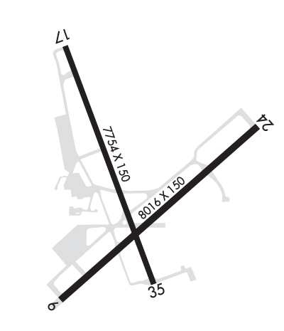
Runway Identifications
Runway Identification: 06/24Length: 8016 ft
Width: 150 ft
Surface: ASPHALT-GOOD CONDITION
Edge lights: High IntensityTreatment: GROOVED
Weight: PCN 78 /F/B/W/T
| | Runway: 06 | | Runway: 24 |
| Mag heading: | 58° | Mag heading: | 238° |
| Rwy Slope: | -.01% Down | Rwy Slope: | .01% Up |
| Approach: | ILS/DME | Approach: | ILS |
| Pattern: | Left Traffic | Pattern: | Left Traffic |
| Markings: | PRECISION INSTRUMENT | Markings: | PRECISION INSTRUMENT |
| Marking Condition: | GOOD | Marking Condition: | GOOD |
| Arresting Dev: | | Arresting Dev: | |
| Lat & Long: | N3415.7 W07754.6 | Lat. & Long.: | N3416.6 W07753.4 |
| Elev: | 21.0 ft. MSL | Elev: | 20.2 ft. MSL |
| TCH: | 57 ft. AGL | TCH: | 48 ft. AGL |
| Visual Glide Path: | 3.00 degrees | Visual Glide Path: | 3.00 degrees |
| Displaced Threshold: | No | Displaced Threshold: | No |
| Touchdown Zone: | YES | Touchdown Zone: | YES |
| Touchdown Elev.: | 28.0 feet | Touchdown Elev.: | 26.0 feet |
| Visual Glide Slope: | 4-Light PAPI on RIGHT side of Runway | Visual Glide Slope: | 4-Light PAPI on LEFT side of Runway |
| RVR Equipment: | TOUCHDOWN-ROLLOUT | RVR Equipment: | TOUCHDOWN-ROLLOUT |
| RVV Equipment: | NO | RVV Equipment: | NO |
| Approach Lights: | | Approach Lights: | MALSR - 1,400 foot medium intensity approach lighting system with runway alignment indicator lights |
| REIL: | YES | REIL: | NO |
| Centerline Lights: | NO | Centerline Lights: | NO |
| Touchdown lights: | NO | Touchdown lights: | NO |
| Runway Category: | Precision Instrument Runway | Runway Category: | Precision Instrument Runway |
| Declared Distances: | TORA:8016' TODA:8016' ASDA:8016' LDA:8016' | Declared Distances: | TORA:8016' TODA:8016' ASDA:8016' LDA:8016' |
Runway Identification: 17/35Length: 7754 ft
Width: 150 ft
Surface: ASPHALT-GOOD CONDITION
Edge lights: High IntensityTreatment: GROOVED
Weight: PCN 61 /F/B/W/T
| | Runway: 17 | | Runway: 35 |
| Mag heading: | 169° | Mag heading: | 349° |
| Rwy Slope: | -.16% Down | Rwy Slope: | .16% Up |
| Approach: | | Approach: | ILS |
| Pattern: | Left Traffic | Pattern: | Left Traffic |
| Markings: | PRECISION INSTRUMENT | Markings: | PRECISION INSTRUMENT |
| Marking Condition: | GOOD | Marking Condition: | GOOD |
| Arresting Dev: | | Arresting Dev: | |
| Lat & Long: | N3417.0 W07754.6 | Lat. & Long.: | N3415.8 W07754.1 |
| Elev: | 30.9 ft. MSL | Elev: | 18.3 ft. MSL |
| TCH: | 50 ft. AGL | TCH: | 36 ft. AGL |
| Visual Glide Path: | 3.00 degrees | Visual Glide Path: | 3.00 degrees |
| Displaced Threshold: | 350 feet | Displaced Threshold: | 400 feet |
| Touchdown Zone: | YES | Touchdown Zone: | YES |
| Touchdown Elev.: | 31.7 feet | Touchdown Elev.: | 30.7 feet |
| Visual Glide Slope: | 4-Light PAPI on LEFT side of Runway | Visual Glide Slope: | 4-Light PAPI on LEFT side of Runway |
| RVR Equipment: | ROLLOUT | RVR Equipment: | TOUCHDOWN |
| RVV Equipment: | NO | RVV Equipment: | NO |
| Approach Lights: | | Approach Lights: | MALSR - 1,400 foot medium intensity approach lighting system with runway alignment indicator lights |
| REIL: | YES | REIL: | NO |
| Centerline Lights: | NO | Centerline Lights: | NO |
| Touchdown lights: | NO | Touchdown lights: | NO |
| Runway Category: | Runway with a Non-precision Approach having visibility minimums greater than 3/4 mile | Runway Category: | Precision Instrument Runway |
| Declared Distances: | TORA:7754' TODA:7754' ASDA:6954' LDA:6604' | Declared Distances: | TORA:7754' TODA:7754' ASDA:7604' LDA:7204' |

