Current Weather/Notams (Metars, TAFs, Notams, NWS Forecast, PIREPS, and nearby weather)
Customs Information Send updates to Support@FltPlan.com
Customs Not Available
Database effective 05/16/2024
Airport Diagram might not be current.
|
| Facility Name: | JACK BARSTOW |
| City Name: | MIDLAND |
| County: | MIDLAND |
| State abbrev: | MI |
| State Name: | MICHIGAN |
| | |
| Ownership: | PUBLICLY OWNED |
| Use: | OPEN TO THE PUBLIC |
| Owner's Name: | CITY OF MIDLAND |
| Address: | 333 W ELLSWORTH ST |
| | MIDLAND, MI 48640-5132 |
| Owner's Phone: | 989-837-3300 |
| | |
| Manager's Name: | SARAH PAGANO |
| Address: | 6603 BARSTOW DR |
| | MIDLAND, MI 48642-7783 |
| Phone: | 989-835-3231; CELL 989-525-5206. |
| | |
| FAA Region: | GREAT LAKES |
| FAA Field Office: | DET |
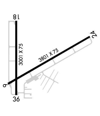
Runway Identifications
Runway Identification: 06/24Length: 3801 ft
Width: 75 ft
Surface: ASPHALT-GOOD CONDITION
Edge lights: Medium IntensityTreatment: NONE
| | Runway: 06 | | Runway: 24 |
| Mag heading: | 66° | Mag heading: | 246° |
| Rwy Slope: | .36% Up | Rwy Slope: | -.36% Down |
| Approach: | | Approach: | |
| Pattern: | Left Traffic | Pattern: | Left Traffic |
| Markings: | NONPRECISION INSTRUMENT | Markings: | NONPRECISION INSTRUMENT |
| Marking Condition: | FAIR | Marking Condition: | FAIR |
| Arresting Dev: | | Arresting Dev: | |
| Lat & Long: | N4339.6 W08415.9 | Lat. & Long.: | N4339.9 W08415.2 |
| Elev: | 621.2 ft. MSL | Elev: | 634.7 ft. MSL |
| TCH: | 32 ft. AGL | TCH: | 24 ft. AGL |
| Visual Glide Path: | 3.00 degrees | Visual Glide Path: | 3.00 degrees |
| Displaced Threshold: | No | Displaced Threshold: | No |
| Touchdown Zone: | YES | Touchdown Zone: | YES |
| Touchdown Elev.: | 628.2 feet | Touchdown Elev.: | 634.7 feet |
| Visual Glide Slope: | 2-Light PAPI on LEFT side of Runway | Visual Glide Slope: | 2-Light PAPI on LEFT side of Runway |
| RVR Equipment: | | RVR Equipment: | |
| RVV Equipment: | NO | RVV Equipment: | NO |
| Approach Lights: | | Approach Lights: | |
| REIL: | YES | REIL: | YES |
| Centerline Lights: | NO | Centerline Lights: | NO |
| Touchdown lights: | NO | Touchdown lights: | NO |
| Runway Category: | Runway with a Non-precision Approach | Runway Category: | Runway with a Non-precision Approach |
| Declared Distances: | | Declared Distances: | |
| Obstructions: | TREE | Obstructions: | TREE |
| Marked: | NOT Marked/Lighted | Marked: | NOT Marked/Lighted |
| Clearance slope: | 12:1 | Clearance slope: | 16:1 |
| Obstruction height: | 42 feet AGL | Obstruction height: | 65 feet AGL |
| Dist. from runway: | 715 feet | Dist. from runway: | 1276 feet |
| Centerline offset: | 110 left of centerline | Centerline offset: | 75 feet left of centerline |
| Comments: | | Comments: | |
Runway Identification: 18/36Length: 3001 ft
Width: 75 ft
Surface: ASPHALT-GOOD CONDITION
Edge lights: Medium IntensityTreatment: NONE
| | Runway: 18 | | Runway: 36 |
| Mag heading: | 186° | Mag heading: | 6° |
| Rwy Slope: | -.22% Down | Rwy Slope: | .22% Up |
| Approach: | | Approach: | |
| Pattern: | Left Traffic | Pattern: | Left Traffic |
| Markings: | NONPRECISION INSTRUMENT | Markings: | NONPRECISION INSTRUMENT |
| Marking Condition: | FAIR | Marking Condition: | FAIR |
| Arresting Dev: | | Arresting Dev: | |
| Lat & Long: | N4340.0 W08415.8 | Lat. & Long.: | N4339.5 W08415.8 |
| Elev: | 627.8 ft. MSL | Elev: | 621.1 ft. MSL |
| TCH: | 35 ft. AGL | TCH: | 29 ft. AGL |
| Visual Glide Path: | 3.30 degrees | Visual Glide Path: | 3.30 degrees |
| Displaced Threshold: | No | Displaced Threshold: | No |
| Touchdown Zone: | YES | Touchdown Zone: | YES |
| Touchdown Elev.: | 627.8 feet | Touchdown Elev.: | 627.8 feet |
| Visual Glide Slope: | 2-Light PAPI on LEFT side of Runway | Visual Glide Slope: | 2-Light PAPI on LEFT side of Runway |
| RVR Equipment: | | RVR Equipment: | |
| RVV Equipment: | NO | RVV Equipment: | NO |
| Approach Lights: | | Approach Lights: | |
| REIL: | YES | REIL: | YES |
| Centerline Lights: | NO | Centerline Lights: | NO |
| Touchdown lights: | NO | Touchdown lights: | NO |
| Runway Category: | Runway with a Visual Approach | Runway Category: | Runway with a Visual Approach |
| Declared Distances: | | Declared Distances: | |
| Obstructions: | TREE | Obstructions: | TREE |
| Marked: | NOT Marked/Lighted | Marked: | NOT Marked/Lighted |
| Clearance slope: | 17:1 | Clearance slope: | 17:1 |
| Obstruction height: | 70 feet AGL | Obstruction height: | 58 feet AGL |
| Dist. from runway: | 1393 feet | Dist. from runway: | 1226 feet |
| Centerline offset: | 80 left of centerline | Centerline offset: | 125 feet right of centerline |
| Comments: | | Comments: | |
