Click here for more info on on SMS!

KIKG

KLEBERG COUNTY
KINGSVILLE
TX
Time Zone: Central
Lat: N 2733.1
Long: W 09801.9
Elev: 130
Var: -06
Longest Runway: 6000
AWOS: 119.07
CTAF: 122.7

FBO & Flight Services info for KIKG

FBOs: Update your Fuel Prices

MIKE'S ACFT SHOPPh: 361-595-8540 Fax: 361-592-4878 Freq: 122.7
Service
Jet
100LL
SAF
MoGas
Fuel Avail: PRIST PREMIXED
Full6.006.45    Last Update: 04/08/2024 12:49

Self        
 Address: KLEBERG COUNTY AIRPORT HIGHAY 141   KINGSVILLE, TX 78363
AWOSPh: 361-592-9152
-
Freq: 119.07  
If you are an FBO, call 1-203-262-1700 to update your info or email: FltPlan.Advertising@garmin.com
Advertise your FBO on FltPlan.com

Runway & Approach Info for KIKG
Rwy
Length
Land Dist**
Approach*
  Rwy
Length
Land Dist**
Approach*
13
6000x75  6000'          
 
  
31
  6000x75  6000'          
 
 * only ILS, LOC, LDA, and SDF approaches to a specific runway are shown
** For any Declared Landing Distance Available, please see A/FD or Approach plates
Runway Weight Capability (lbs.) Help
Runway IDSingle WheelDouble WheelDouble Tandem WheelDual Double Wheel
13/3135,00047,00070,000N/A
These numbers are Advisory and are not limits.   The Airport Manager should have more accurate Weight Limits
Approach Charts
Approaches    
Current Weather/Notams
Customs Information Send updates to Support@FltPlan.com
Customs Not Available
Database effective 05/16/2024
Airport Diagram of KIKG
Airport Diagram might not be current.

Facility Name: KLEBERG COUNTY
City Name: KINGSVILLE
County: KLEBERG
State abbrev: TX
State Name: TEXAS
   
Ownership: PUBLICLY OWNED
Use: OPEN TO THE PUBLIC
Owner's Name: KLEBERG COUNTY
Address: PO BOX 752; JUDGE RUDY MADRID, KLEBERG CO.
 KINGSVILLE, TX 78364
Owner's Phone: 361-595-8585
  
Manager's Name: MIKE MUZYCZYN, FBO
Address: PO BOX 53
 KINGSVILLE, TX 78364
Phone: 361-592-1225
   
FAA Region: SOUTHWEST
FAA Field Office: TEX


Sunrise / Sunset times for KLEBERG COUNTY

DateSunriseSunset
04/25/24 Thursday6:5720:03
04/26/24 Friday6:5620:04
04/27/24 Saturday6:5620:04
04/28/24 Sunday6:5520:05
04/29/24 Monday6:5420:05
04/30/24 Tuesday6:5320:06
05/01/24 Wednesday6:5220:06
05/02/24 Thursday6:5120:07
05/03/24 Friday6:5120:08
05/04/24 Saturday6:5020:08
05/05/24 Sunday6:4920:09
05/06/24 Monday6:4820:09
05/07/24 Tuesday6:4820:10
05/08/24 Wednesday6:4720:10

Airport Facilities

Airport Attendance ScheduleMON-FRI 0800-1630, SAT-SUN 0800-1500
Airport Status OPERATIONAL (This Status can change at any time - please check NOTAMS)
Airport Lighting ScheduleMIRL RWY 13/31 PRESET LOW INTST; TO INCR INTST & ACTVT REIL RWYS 13 & 31 - CTAF.
Airport Storage AvailableTie Downs, Hanger
Extra Services AvailableNONE
Wind IndicatorYES - (lighted)
Control TowerNO
CTAF Frequency122.700
Unicom Frequency122.700
Rotating Beacon ColorWG
Segmented CircleYES
Landing FeeYES; LDG FEE FOR TURBINE & JET ACFT. FEE WAIVED WITH MNM FUEL PURCHASE.

Airport Inspection Data

Airport InspectedSTATE - performed by PRIVATE CONTRACT PERSONNEL
Inspection Date04/20/2023

Airport Services

Type of Fuel AvailableGrade 100LL, JET A (freeze point -40C)
Airframe Repair ServiceMAJOR
Power Plant Repair ServiceMAJOR

Geographic Data

LatitudeN2733.1
LongitudeW09801.9 (ESTIMATED)
Arpt Elevation130ft (SURVEYED)
Magnetic Variation06E
9 miles Wof KINGSVILLE
Traffic Pattern Altitude
Sectional ChartBROWNSVILLE

Aircraft Data

Operations (Reported)YearlyAvg. Daily
General Aviation Transient 6072
General Aviation Local 2101
Air Taxi 2271
Commerical 00
Commuter 00
Military 4801
Aircraft based on Field
General Aviation Singles 10
General Aviation Multi 1
Jet Aircraft 0
General Aviation Helicopters 0
Military Aircraft 0
Gliders 0
Ultralights 0

FAA Services

FSS on field NO
FSS tie-in SAN ANGELO
FSS Phone 1-800-WX-BRIEF
Who issues Notams SJT
Notam D service at airport YES
ARTCC Name HOUSTON

Federal Status

Airport Certification
Aircraft Rescue & Firefighting IndexNone
Airport of EntryNo
Custom Landing RightsNo
Joint Civil/MilitaryNo
Military Landing rightsYES

Federal Agreements

NATIONAL PLAN OF INTEGRATED AIRPORT SYSTEMS (NPIAS)
GRANT AGREEMENTS UNDER FAAP/ADAP/AIP
ASSURANCES PURSUANT TO TITLE VI, CIVIL RIGHTS ACT OF 1964

Remarks

THIS AIRPORT HAS BEEN SURVEYED BY THE NATIONAL GEODETIC SURVEY.
BIRDS ON & INVOF ARPT.
FOR CD CTC HOUSTON ARTCC AT 281-230-5622.
Airport Communications & Frequencies:
CTAF Frequency:
122.700
Unicom Frequency:
122.700
Remarks
  • APCH/DEP CTL SVC PRVDD BY HOUSTON ARTCC (ZHU) ON 128.15/350.3 (KINGSVILLE RCAG) WHEN KINGSVILLE APCH CTL (NQI) CLSD.
  • KINGSVILLE Primary Approach Frequencies:  
    119.9
    290.45
    KINGSVILLE Primary Departure Frequencies:  
    119.9
    305.2
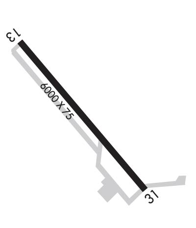
    Runway Identifications
    Runway Identification: 13/31
    Length: 6000 ft
    Width: 75 ft
    Surface: ASPHALT-GOOD CONDITION
    Edge lights: Medium Intensity

    Treatment: NONE

     Runway: 13   Runway: 31
    Mag heading: 134°Mag heading: 314°
    Rwy Slope: -.09% DownRwy Slope: .09% Up
    Approach: Approach:
    Pattern: Left TrafficPattern: Left Traffic
    Markings: NONPRECISION INSTRUMENTMarkings: NONPRECISION INSTRUMENT
    Marking Condition: POOR; RWY MKGS FADED/DISCOLORED.Marking Condition: POOR; RWY MKGS FADED/DISCOLORED.
    Arresting Dev: Arresting Dev:
    Lat & Long: N2733.4  W09802.2Lat. & Long.: N2732.7  W09801.5
    Elev: 130.1 ft. MSLElev: 124.5 ft. MSL
    TCH: 39 ft. AGLTCH: 41 ft. AGL
    Visual Glide Path: 3.00 degreesVisual Glide Path: 3.00 degrees
    Displaced Threshold: NoDisplaced Threshold: No
    Touchdown Zone: YESTouchdown Zone: YES
    Touchdown Elev.: 130.1 feetTouchdown Elev.: 127.7 feet
    Visual Glide Slope: 4-Light PAPI on LEFT side of RunwayVisual Glide Slope: 4-Light PAPI on LEFT side of Runway
    RVR Equipment: RVR Equipment:
    RVV Equipment: NORVV Equipment: NO
    Approach Lights: Approach Lights:
    REIL: YESREIL: YES
    Centerline Lights: NOCenterline Lights: NO
    Touchdown lights: NOTouchdown lights: NO
    Runway Category: DRunway Category: Runway with a Visual Approach
    Declared Distances: Declared Distances:
    Obstructions: TREESObstructions: TREE
    Marked: NOT Marked/LightedMarked: NOT Marked/Lighted
    Clearance slope: 270 FT L.Clearance slope: 46:1
    Obstruction height: 20 feet AGLObstruction height: 26 feet AGL
    Dist. from runway: 201 feetDist. from runway: 1400 feet
    Centerline offset: 270 left of centerlineCenterline offset: 540 feet left of centerline
    Comments: 20 FT TREES 0-199 FT FM THR 270 FT L.Comments:
    C:13/P: