Click here for more info on on SMS!

KIJX

JACKSONVILLE MUNI
JACKSONVILLE
IL
Time Zone: Central
Lat: N 3946.5
Long: W 09014.3
Elev: 624
Var: -03
Longest Runway: 5000
Clr Del: 118.45
AWOS: 120.52
CTAF: 122.8

FBO & Flight Services info for KIJX

FBOs: Update your Fuel Prices

JACKSONVILLE APTPh: 217-243-5824 Fax: 217-243-7954 Freq: 122.8
Service
Jet
100LL
SAF
MoGas
Fuel Avail: PRIST PREMIXED 7 Days - 7am cst - Dusk ( Self Serve After Hours )
Full5.895.45    Last Update: 04/12/2024 07:59

Self5.895.45    
 Address: 1956 BALDWIN RD   JACKSONVILLE, IL 62650
AWOSPh: 217-243-6379
-
Freq: 120.52  
If you are an FBO, call 1-203-262-1700 to update your info or email: FltPlan.Advertising@garmin.com
Advertise your FBO on FltPlan.com

Runway & Approach Info for KIJX
Rwy
Length
Land Dist**
Approach*
  Rwy
Length
Land Dist**
Approach*
04
4001x75  4001'          
 
  
22
  4001x75  4001'          
 
13
5000x75  5000'          
 
  
31
  5000x75  5000'          
 
 * only ILS, LOC, LDA, and SDF approaches to a specific runway are shown
** For any Declared Landing Distance Available, please see A/FD or Approach plates
Runway Weight Capability (lbs.) Help
Runway IDSingle WheelDouble WheelDouble Tandem WheelDual Double Wheel
04/22N/AN/AN/AN/A
13/3122,00028,000N/AN/A
These numbers are Advisory and are not limits.   The Airport Manager should have more accurate Weight Limits
Approach Charts
Approaches    
Current Weather/Notams
Customs Information Send updates to Support@FltPlan.com
Customs Not Available
Database effective 05/16/2024
Airport Diagram of KIJX
Airport Diagram might not be current.

Facility Name: JACKSONVILLE MUNI
City Name: JACKSONVILLE
County: MORGAN
State abbrev: IL
State Name: ILLINOIS
   
Ownership: PUBLICLY OWNED
Use: OPEN TO THE PUBLIC
Owner's Name: JACKSONVILLE AIRPORT AUTH
Address: 1956 BALDWIN RD
 JACKSONVILLE, IL 62650
Owner's Phone: 217-243-5824
  
Manager's Name: SHASTIN SAXER
Address: 1956 BALDWIN RD, JACKSONVILLE AIRPORT; EMAIL ADDRESS: MANAGER@FLYIJX.COM. (ALL LOWER CASE)
 JACKSONVILLE, IL 62650
Phone: 217-243-5824
   
FAA Region: GREAT LAKES
FAA Field Office: CHI


Sunrise / Sunset times for JACKSONVILLE MUNI

DateSunriseSunset
04/25/24 Thursday6:0819:50
04/26/24 Friday6:0719:51
04/27/24 Saturday6:0619:52
04/28/24 Sunday6:0419:53
04/29/24 Monday6:0319:54
04/30/24 Tuesday6:0219:55
05/01/24 Wednesday6:0019:56
05/02/24 Thursday5:5919:57
05/03/24 Friday5:5819:58
05/04/24 Saturday5:5719:59
05/05/24 Sunday5:5620:00
05/06/24 Monday5:5520:01
05/07/24 Tuesday5:5420:02
05/08/24 Wednesday5:5220:03

Airport Facilities

Airport Attendance Schedule7 Days A Week 0700-DUSK
Airport Status OPERATIONAL (This Status can change at any time - please check NOTAMS)
Airport Lighting ScheduleACTVT MIRL RY 13/31, 04/22, REIL RYS 22, 13 & 31, & TWY LGTS - CTAF.
Airport Storage AvailableTie Downs, Hanger
Extra Services AvailableFlight Instruction, Aircraft Rental
Wind IndicatorYES - (lighted)
Control TowerNO
CTAF Frequency122.800
Unicom Frequency122.800
Rotating Beacon ColorWG
Segmented CircleNO
Landing FeeNO

Airport Inspection Data

Airport InspectedSTATE - performed by STATE AERONAUTICAL PERSONNEL
Inspection Date04/28/2023

Airport Services

Type of Fuel AvailableGrade 100LL, JET A (freeze point -40C)
Airframe Repair ServiceMAJOR
Power Plant Repair ServiceMAJOR

Geographic Data

LatitudeN3946.5
LongitudeW09014.3 (ESTIMATED)
Arpt Elevation623ft (SURVEYED)
Magnetic Variation03E
3 miles Nof JACKSONVILLE
Traffic Pattern Altitude
Sectional ChartST LOUIS

Aircraft Data

Operations (Reported)YearlyAvg. Daily
General Aviation Transient 500014
General Aviation Local 600016
Air Taxi 10003
Commerical 00
Commuter 00
Military 00
Aircraft based on Field
General Aviation Singles 31
General Aviation Multi 2
Jet Aircraft 0
General Aviation Helicopters 1
Military Aircraft 0
Gliders 0
Ultralights 0

FAA Services

FSS on field NO
FSS tie-in SAINT LOUIS
FSS Phone 1-800-WX-BRIEF
Who issues Notams IJX
Notam D service at airport YES
ARTCC Name KANSAS CITY

Federal Status

Airport Certification
Aircraft Rescue & Firefighting IndexNone
Airport of EntryNo
Custom Landing RightsNo
Joint Civil/MilitaryNo
Military Landing rightsYES

Federal Agreements

NATIONAL PLAN OF INTEGRATED AIRPORT SYSTEMS (NPIAS)
GRANT AGREEMENTS UNDER FAAP/ADAP/AIP
ASSURANCES PURSUANT TO TITLE VI, CIVIL RIGHTS ACT OF 1964

Remarks

DEER ON & INVOF OF ARPT.
FOR CD CTC ST LOUIS APCH 314-890-1017.
Airport Communications & Frequencies:
Clearance Delivery Frequencies:
118.45
CTAF Frequency:
122.800
Unicom Frequency:
122.800
Remarks
  • APCH/DEP SVC PRVDD BY ST LOUIS TRACON (T75) ON FREQS 126.15/323.0 0600-2200. APCH/DEP SVC PRVDD BY KANSAS CITY ARTCC (ZKC) ON FREQS 127.275/307.1 (JACKSONVILLE RCAG) 2200-0600.
  • SAINT LOUIS Primary Approach Frequencies:  
    126.15
    323.0
    SAINT LOUIS Primary Departure Frequencies:  
    126.15
    323.0
    Runway Identifications
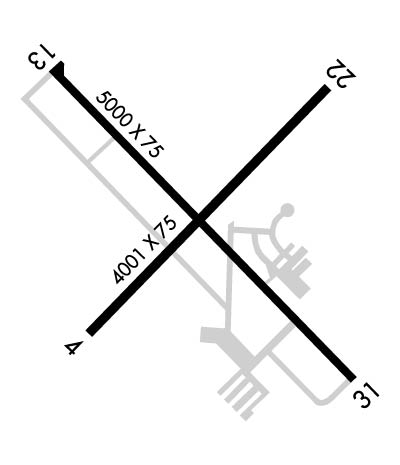
    Runway Identification: 04/22
    Length: 4001 ft
    Width: 75 ft
    Surface: ASPHALT-GOOD CONDITION
    Edge lights: Medium Intensity

    Treatment: NONE

     Runway: 04   Runway: 22
    Mag heading: 42°Mag heading: 222°
    Rwy Slope: .03% UpRwy Slope: -.03% Down
    Approach: Approach:
    Pattern: Left TrafficPattern: Left Traffic
    Markings: BASICMarkings: BASIC
    Marking Condition: FAIRMarking Condition: FAIR
    Arresting Dev: Arresting Dev:
    Lat & Long: N3946.3  W09014.6Lat. & Long.: N3946.7  W09014.0
    Elev: 617.1 ft. MSLElev: 618.2 ft. MSL
    TCH: TCH:
    Visual Glide Path: Visual Glide Path:
    Displaced Threshold: NoDisplaced Threshold: No
    Touchdown Zone: YESTouchdown Zone: YES
    Touchdown Elev.: 620.4 feetTouchdown Elev.: 620.4 feet
    Visual Glide Slope: Visual Glide Slope:
    RVR Equipment: RVR Equipment:
    RVV Equipment: NORVV Equipment: NO
    Approach Lights: Approach Lights:
    REIL: NOREIL: YES
    Centerline Lights: NOCenterline Lights: NO
    Touchdown lights: NOTouchdown lights: NO
    Runway Category: Runway with a Non-precision ApproachRunway Category: Runway with a Non-precision Approach
    Declared Distances: Declared Distances:
    Runway Identification: 13/31
    Length: 5000 ft
    Width: 75 ft
    Surface: ASPHALT-GOOD CONDITION
    Edge lights: Medium Intensity

    Treatment: NONE

     Runway: 13   Runway: 31
    Mag heading: 132°Mag heading: 312°
    Rwy Slope: .09% UpRwy Slope: -.09% Down
    Approach: Approach:
    Pattern: Left TrafficPattern: Left Traffic
    Markings: NONPRECISION INSTRUMENTMarkings: NONPRECISION INSTRUMENT
    Marking Condition: FAIRMarking Condition: FAIR
    Arresting Dev: Arresting Dev:
    Lat & Long: N3946.8  W09014.7Lat. & Long.: N3946.2  W09013.9
    Elev: 616.6 ft. MSLElev: 621.0 ft. MSL
    TCH: 36 ft. AGLTCH:
    Visual Glide Path: 3.00 degreesVisual Glide Path:
    Displaced Threshold: NoDisplaced Threshold: No
    Touchdown Zone: YESTouchdown Zone: YES
    Touchdown Elev.: 622.1 feetTouchdown Elev.: 623.9 feet
    Visual Glide Slope: 4-BOX VASI ON LEFT SIDE OF RUNWAYVisual Glide Slope:
    RVR Equipment: RVR Equipment:
    RVV Equipment: NORVV Equipment: NO
    Approach Lights: Approach Lights:
    REIL: YESREIL: YES
    Centerline Lights: NOCenterline Lights: NO
    Touchdown lights: NOTouchdown lights: NO
    Runway Category: Runway with a Non-precision Approach having visibility minimums greater than 3/4 mileRunway Category: Runway with a Non-precision Approach having visibility minimums greater than 3/4 mile
    Declared Distances: Declared Distances:
    C:4/P: