Current Weather/Notams (Metars, TAFs, Notams, NWS Forecast, PIREPS, and nearby weather)
Customs Information Send updates to Support@FltPlan.com
Customs Not Available
Database effective 05/16/2024
Airport Diagram might not be current.
|
| Facility Name: | WINDHAM |
| City Name: | WILLIMANTIC |
| County: | WINDHAM |
| State abbrev: | CT |
| State Name: | CONNECTICUT |
| | |
| Ownership: | PUBLICLY OWNED |
| Use: | OPEN TO THE PUBLIC |
| Owner's Name: | CONNECTICUT AIRPORT AUTHORITY |
| Address: | SUITE 160, 334 ELLA GRASSO TURNPIKE |
| | WINDSOR LOCKS, CT 06096 |
| Owner's Phone: | 860-292-2000 |
| | |
| Manager's Name: | ROBERT PELLIGRINO |
| Address: | CONNECTICUT AIRPORT AUTHORITY, 155 TOWER AVE. |
| | GROTON, CT 06340 |
| Phone: | 860-982-2443 |
| | |
| FAA Region: | NEW ENGLAND |
| FAA Field Office: | NONE |
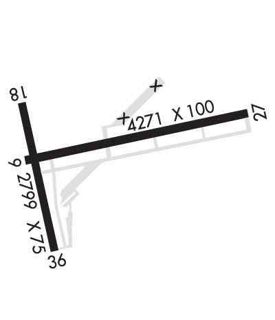
Runway Identifications
Runway Identification: 09/27Length: 4271 ft
Width: 100 ft
Surface: ASPHALT-GOOD CONDITION
Edge lights: Medium IntensityTreatment: NONE
| | Runway: 09 | | Runway: 27 |
| Mag heading: | 89° | Mag heading: | 269° |
| Rwy Slope: | .00% | Rwy Slope: | .00% |
| Approach: | | Approach: | LOC/DME |
| Pattern: | Left Traffic | Pattern: | Left Traffic |
| Markings: | NONPRECISION INSTRUMENT | Markings: | NONPRECISION INSTRUMENT |
| Marking Condition: | FAIR | Marking Condition: | FAIR |
| Arresting Dev: | | Arresting Dev: | |
| Lat & Long: | N4144.6 W07211.1 | Lat. & Long.: | N4144.8 W07210.2 |
| Elev: | 239.1 ft. MSL | Elev: | 239.1 ft. MSL |
| TCH: | | TCH: | |
| Visual Glide Path: | | Visual Glide Path: | |
| Displaced Threshold: | 258 feet | Displaced Threshold: | No |
| Touchdown Zone: | YES | Touchdown Zone: | YES |
| Touchdown Elev.: | 239.4 feet | Touchdown Elev.: | 239.4 feet |
| Visual Glide Slope: | | Visual Glide Slope: | |
| RVR Equipment: | | RVR Equipment: | |
| RVV Equipment: | NO | RVV Equipment: | NO |
| Approach Lights: | | Approach Lights: | |
| REIL: | NO | REIL: | YES |
| Centerline Lights: | NO | Centerline Lights: | NO |
| Touchdown lights: | NO | Touchdown lights: | NO |
| Runway Category: | Runway with a Non-precision Approach having visibility minimums greater than 3/4 mile | Runway Category: | Runway with a Non-precision Approach having visibility minimums greater than 3/4 mile |
| Declared Distances: | | Declared Distances: | |
| Obstructions: | TREES | Obstructions: | TREE |
| Marked: | NOT Marked/Lighted | Marked: | NOT Marked/Lighted |
| Clearance slope: | APCH RATIO 25:1 TO DTHR. | Clearance slope: | 5:1 |
| Obstruction height: | 53 feet AGL | Obstruction height: | 36 feet AGL |
| Dist. from runway: | 210 feet | Dist. from runway: | 415 feet |
| Centerline offset: | 220 left of centerline | Centerline offset: | 255 feet left of centerline |
| Comments: | | Comments: | |
Runway Identification: 18/36Length: 2799 ft
Width: 75 ft
Surface: ASPHALT-GOOD CONDITION
Edge lights: Treatment: NONE
| | Runway: 18 | | Runway: 36 |
| Mag heading: | 178° | Mag heading: | 358° |
| Rwy Slope: | .40% Up | Rwy Slope: | -.40% Down |
| Approach: | | Approach: | |
| Pattern: | Left Traffic | Pattern: | Left Traffic |
| Markings: | BASIC | Markings: | BASIC |
| Marking Condition: | GOOD | Marking Condition: | GOOD |
| Arresting Dev: | | Arresting Dev: | |
| Lat & Long: | N4144.8 W07211.1 | Lat. & Long.: | N4144.3 W07211.0 |
| Elev: | 234.8 ft. MSL | Elev: | 245.9 ft. MSL |
| TCH: | | TCH: | |
| Visual Glide Path: | | Visual Glide Path: | |
| Displaced Threshold: | No | Displaced Threshold: | 799 feet |
| Touchdown Zone: | YES | Touchdown Zone: | YES |
| Touchdown Elev.: | 246.1 feet | Touchdown Elev.: | 243.1 feet |
| Visual Glide Slope: | | Visual Glide Slope: | |
| RVR Equipment: | | RVR Equipment: | |
| RVV Equipment: | NO | RVV Equipment: | NO |
| Approach Lights: | | Approach Lights: | |
| REIL: | NO | REIL: | NO |
| Centerline Lights: | NO | Centerline Lights: | NO |
| Touchdown lights: | NO | Touchdown lights: | NO |
| Runway Category: | Runway with a Visual Approach | Runway Category: | Runway with a Visual Approach |
| Declared Distances: | | Declared Distances: | |
| Obstructions: | TREES | Obstructions: | TREES |
| Marked: | NOT Marked/Lighted | Marked: | NOT Marked/Lighted |
| Clearance slope: | 13:1 | Clearance slope: | 10:1; APCH RATIO 20:1 TO DTHR. |
| Obstruction height: | 46 feet AGL | Obstruction height: | 60 feet AGL |
| Dist. from runway: | 800 feet | Dist. from runway: | 800 feet |
| Centerline offset: | 200 right of centerline | Centerline offset: | 50 feet left of centerline |
| Comments: | | Comments: | |

