Current Weather/Notams (Metars, TAFs, Notams, NWS Forecast, PIREPS, and nearby weather)
Customs Information Send updates to Support@FltPlan.com
Customs Not Available
Database effective 04/18/2024
Airport Diagram might not be current.
|
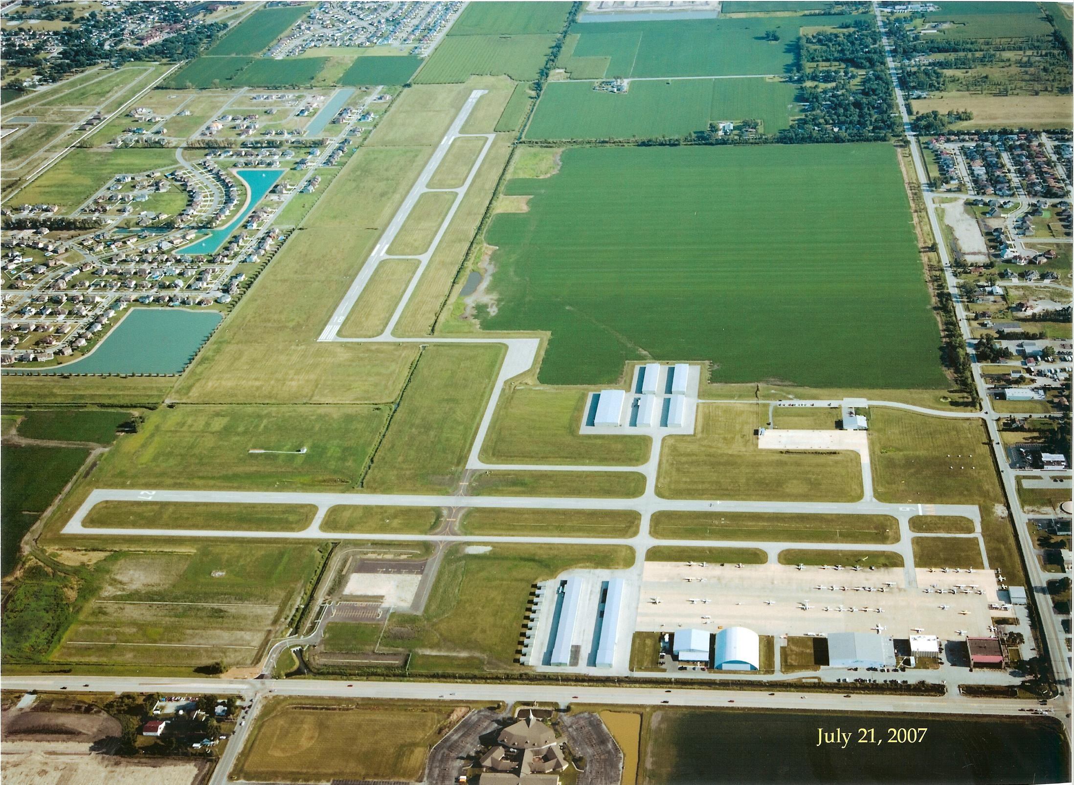
| Facility Name: | LANSING MUNI |
| City Name: | CHICAGO |
| County: | COOK |
| State abbrev: | IL |
| State Name: | ILLINOIS |
| | |
| Ownership: | PUBLICLY OWNED |
| Use: | OPEN TO THE PUBLIC |
| Owner's Name: | VILLAGE OF LANSING |
| Address: | 3141 RIDGE RD |
| | LANSING, IL 60438-3021 |
| Owner's Phone: | (708) 895-7200 |
| | |
| Manager's Name: | BRIAN HANIGAN |
| Address: | 3250 BOB MALKAS DR; EMAIL ADDRESS: PPATLAK@VILLAGEOFLANSING.ORG (ALL LOWER CASE) |
| | LANSING, IL 60438 |
| Phone: | (708) 418-5888; (708) 895-7200 |
| | |
| FAA Region: | GREAT LAKES |
| FAA Field Office: | CHI |
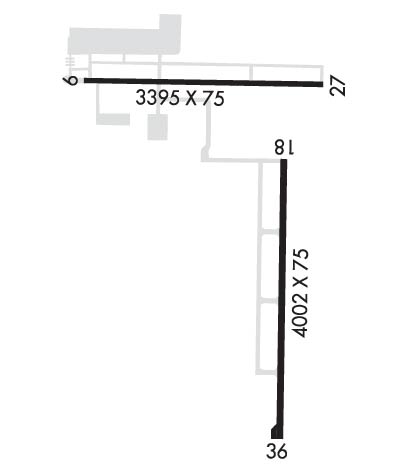
Runway Identifications
Runway Identification: 09/27Length: 3395 ft
Width: 75 ft
Surface: ASPHALT-GOOD CONDITION
Edge lights: Medium IntensityTreatment: POROUS FRICTION COURSE
| | Runway: 09 | | Runway: 27 |
| Mag heading: | 92° | Mag heading: | 272° |
| Rwy Slope: | .06% Up | Rwy Slope: | -.06% Down |
| Approach: | | Approach: | |
| Pattern: | Left Traffic | Pattern: | Left Traffic |
| Markings: | NONPRECISION INSTRUMENT | Markings: | NONPRECISION INSTRUMENT |
| Marking Condition: | FAIR | Marking Condition: | FAIR |
| Arresting Dev: | | Arresting Dev: | |
| Lat & Long: | N4132.4 W08732.3 | Lat. & Long.: | N4132.4 W08731.5 |
| Elev: | 614.5 ft. MSL | Elev: | 616.6 ft. MSL |
| TCH: | 40 ft. AGL | TCH: | 40 ft. AGL |
| Visual Glide Path: | 3.00 degrees | Visual Glide Path: | 3.00 degrees |
| Displaced Threshold: | No | Displaced Threshold: | No |
| Touchdown Zone: | YES | Touchdown Zone: | YES |
| Touchdown Elev.: | 616.6 feet | Touchdown Elev.: | 616.6 feet |
| Visual Glide Slope: | 2-Light PAPI on LEFT side of Runway | Visual Glide Slope: | 2-Light PAPI on LEFT side of Runway |
| RVR Equipment: | | RVR Equipment: | |
| RVV Equipment: | NO | RVV Equipment: | NO |
| Approach Lights: | | Approach Lights: | |
| REIL: | YES | REIL: | YES |
| Centerline Lights: | NO | Centerline Lights: | NO |
| Touchdown lights: | NO | Touchdown lights: | NO |
| Runway Category: | Runway with a Non-precision Approach | Runway Category: | Runway with a Non-precision Approach |
| Declared Distances: | | Declared Distances: | |
| Obstructions: | BLDG | Obstructions: | |
| Marked: | NOT Marked/Lighted | Marked: | |
| Clearance slope: | 13:1 | Clearance slope: | 20:1 |
| Obstruction height: | 26 feet AGL | Obstruction height: | |
| Dist. from runway: | 546 feet | Dist. from runway: | |
| Centerline offset: | 95 left of centerline | Centerline offset: | |
| Comments: | | Comments: | |
Runway Identification: 18/36Length: 4002 ft
Width: 75 ft
Surface: ASPHALT-GOOD CONDITION
Edge lights: Medium IntensityTreatment: POROUS FRICTION COURSE
| | Runway: 18 | | Runway: 36 |
| Mag heading: | 182° | Mag heading: | 2° |
| Rwy Slope: | .05% Up | Rwy Slope: | -.05% Down |
| Approach: | | Approach: | LOC/DME |
| Pattern: | Left Traffic | Pattern: | Left Traffic |
| Markings: | NONPRECISION INSTRUMENT | Markings: | NONPRECISION INSTRUMENT |
| Marking Condition: | FAIR | Marking Condition: | FAIR |
| Arresting Dev: | | Arresting Dev: | |
| Lat & Long: | N4132.2 W08731.7 | Lat. & Long.: | N4131.5 W08731.7 |
| Elev: | 616.6 ft. MSL | Elev: | 618.5 ft. MSL |
| TCH: | 40 ft. AGL | TCH: | 40 ft. AGL |
| Visual Glide Path: | 3.00 degrees | Visual Glide Path: | 3.00 degrees |
| Displaced Threshold: | No | Displaced Threshold: | No |
| Touchdown Zone: | YES | Touchdown Zone: | YES |
| Touchdown Elev.: | 619.1 feet | Touchdown Elev.: | 619.7 feet |
| Visual Glide Slope: | 2-Light PAPI on LEFT side of Runway | Visual Glide Slope: | 2-Light PAPI on LEFT side of Runway |
| RVR Equipment: | | RVR Equipment: | |
| RVV Equipment: | NO | RVV Equipment: | NO |
| Approach Lights: | | Approach Lights: | |
| REIL: | YES | REIL: | YES |
| Centerline Lights: | NO | Centerline Lights: | NO |
| Touchdown lights: | NO | Touchdown lights: | NO |
| Runway Category: | Runway with a Visual Approach | Runway Category: | Runway with a Non-precision Approach |
| Declared Distances: | | Declared Distances: | |