Current Weather/Notams (Metars, TAFs, Notams, NWS Forecast, PIREPS, and nearby weather)
Customs Information Send updates to Support@FltPlan.com
Customs Not Available
Database effective 05/16/2024
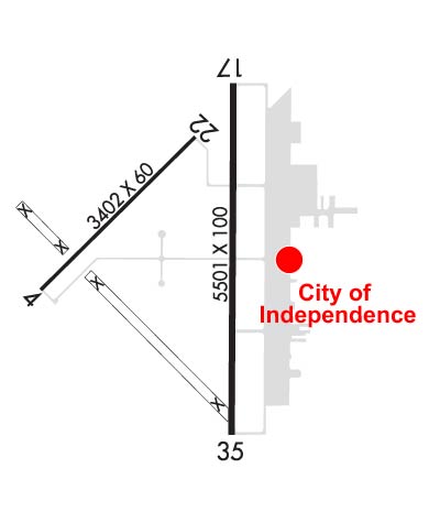
Airport Diagram might not be current. Facility Name: INDEPENDENCE MUNI City Name: INDEPENDENCE County: MONTGOMERY State abbrev: KS State Name: KANSAS Ownership: PUBLICLY OWNED Use: OPEN TO THE PUBLIC Owner's Name: CITY OF INDEPENDENCE Address: 120 N. 6TH INDEPENDENCE, KS 67301 Owner's Phone: 620-332-2500 Manager's Name: AARON SHRADER Address: 498 FREEDOM DRIVE INDEPENDENCE, KS 67301 Phone: 620-332-2531 FAA Region: CENTRAL FAA Field Office: NONE
Runway Identifications Help
Runway Identification: 04/22 Length: 3402 ftWidth: 60 ftSurface: ASPHALT-FAIR CONDITIONEdge lights: Medium Intensity Treatment: NONEWeight: PCN 12 /F/D/X/T Runway: 04 Runway: 22 Mag heading: 43° Mag heading: 223° Rwy Slope: .00% Down Rwy Slope: .00% Up Approach: Approach: Pattern: Left Traffic Pattern: Left Traffic Markings: NONPRECISION INSTRUMENT Markings: NONPRECISION INSTRUMENT Marking Condition: GOOD Marking Condition: GOOD Arresting Dev: Arresting Dev: Lat & Long: N3709.4 W09547.2 Lat. & Long.: N3709.7 W09546.7 Elev: 820.2 ft. MSL Elev: 820.1 ft. MSL TCH: TCH: Visual Glide Path: Visual Glide Path: Displaced Threshold: No Displaced Threshold: No Touchdown Zone: YES Touchdown Zone: YES Touchdown Elev.: 824.7 feet Touchdown Elev.: 824.7 feet Visual Glide Slope: 4-Light PAPI on LEFT side of Runway Visual Glide Slope: 4-Light PAPI on LEFT side of Runway RVR Equipment: RVR Equipment: RVV Equipment: NO RVV Equipment: NO Approach Lights: Approach Lights: REIL: NO REIL: NO Centerline Lights: NO Centerline Lights: NO Touchdown lights: NO Touchdown lights: NO Runway Category: Runway with a Visual Approach Runway Category: Runway with a Visual Approach Declared Distances: Declared Distances:
Runway Identification: 17/35 Length: 5501 ftWidth: 100 ftSurface: ASPHALT-FAIR CONDITIONEdge lights: High Intensity Treatment: NONEWeight: PCN 15 /R/D/X/T Runway: 17 Runway: 35 Mag heading: 178° Mag heading: 358° Rwy Slope: -.03% Down Rwy Slope: .03% Up Approach: Approach: ILS/DME Pattern: Left Traffic Pattern: Left Traffic Markings: NONPRECISION INSTRUMENT Markings: PRECISION INSTRUMENT Marking Condition: GOOD Marking Condition: GOOD Arresting Dev: Arresting Dev: Lat & Long: N3709.9 W09546.6 Lat. & Long.: N3709.0 W09546.6 Elev: 821.1 ft. MSL Elev: 819.4 ft. MSL TCH: TCH: 42 ft. AGL Visual Glide Path: Visual Glide Path: 3.00 degrees Displaced Threshold: No Displaced Threshold: No Touchdown Zone: YES Touchdown Zone: YES Touchdown Elev.: 821.3 feet Touchdown Elev.: 820.9 feet Visual Glide Slope: Visual Glide Slope: 4-Light PAPI on LEFT side of Runway RVR Equipment: RVR Equipment: RVV Equipment: NO RVV Equipment: NO Approach Lights: Approach Lights: MALSR - 1,400 foot medium intensity approach lighting system with runway alignment indicator lights REIL: YES REIL: NO Centerline Lights: NO Centerline Lights: NO Touchdown lights: NO Touchdown lights: NO Runway Category: Runway with a Non-precision Approach having visibility minimums greater than 3/4 mile Runway Category: Precision Instrument Runway Declared Distances: Declared Distances: Obstructions: TREES Obstructions: Marked: NOT Marked/Lighted Marked: Clearance slope: 43:1 Clearance slope: 50:1 Obstruction height: 50 feet AGL Obstruction height: Dist. from runway: 2351 feet Dist. from runway: Centerline offset: Centerline offset: Comments: Comments: