Current Weather/Notams (Metars, TAFs, Notams, NWS Forecast, PIREPS, and nearby weather)
Customs Information Send updates to Support@FltPlan.com
Phone 316-613-4194Fax 316-613-4195Comments Mon-Fri 0800-1630 *2 hrs adance notice required *Maximum passengers per flight: 15 *M-F Call Prior to 1630 on preceeding weekday
Database effective 04/18/2024
Airport Diagram might not be current. Facility Name: WICHITA DWIGHT D EISENHOWER NTL City Name: WICHITA County: SEDGWICK State abbrev: KS State Name: KANSAS Ownership: PUBLICLY OWNED Use: OPEN TO THE PUBLIC Owner's Name: WICHITA AIRPORT AUTHORITY Address: 2173 AIR CARGO ROAD WICHITA, KS 67209 Owner's Phone: 316-946-4700 Manager's Name: MR. JESSE ROMO, A.A.E. Address: 2173 AIR CARGO ROAD WICHITA, KS 67209 Phone: 316-946-4700 FAA Region: CENTRAL FAA Field Office: NONE
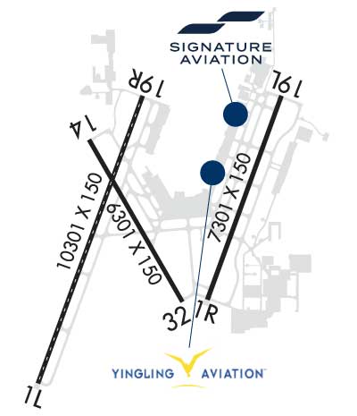
Runway Identifications Help
Runway Identification: 01L/19R Length: 10302 ftWidth: 150 ftSurface: CONCRETE-GOOD CONDITIONEdge lights: High Intensity Treatment: GROOVEDWeight: PCN 72 /R/B/W/T Runway: 01L Runway: 19R Mag heading: 16° Mag heading: 196° Rwy Slope: .17% Up Rwy Slope: -.17% Down Approach: ILS Approach: ILS Pattern: Left Traffic Pattern: Right Traffic Markings: PRECISION INSTRUMENT Markings: PRECISION INSTRUMENT Marking Condition: GOOD Marking Condition: GOOD Arresting Dev: Arresting Dev: Lat & Long: N3738.1 W09726.8 Lat. & Long.: N3739.7 W09726.0 Elev: 1312.5 ft. MSL Elev: 1329.6 ft. MSL TCH: TCH: Visual Glide Path: Visual Glide Path: Displaced Threshold: No Displaced Threshold: No Touchdown Zone: YES Touchdown Zone: YES Touchdown Elev.: 1314.1 feet Touchdown Elev.: 1329.7 feet Visual Glide Slope: Visual Glide Slope: RVR Equipment: TOUCHDOWN-MIDFIELD-ROLLOUT RVR Equipment: TOUCHDOWN-MIDFIELD-ROLLOUT RVV Equipment: NO RVV Equipment: NO Approach Lights: ALSF2 - standard 2,400 foot high intensity approach lighting system with sequenced flashers, Category II or III Approach Lights: MALSR - 1,400 foot medium intensity approach lighting system with runway alignment indicator lights REIL: NO REIL: NO Centerline Lights: YES Centerline Lights: YES Touchdown lights: YES Touchdown lights: NO Runway Category: Precision Instrument Runway Runway Category: Precision Instrument Runway Declared Distances: TORA:10301' TODA:10301' ASDA:10301' LDA:10301' Declared Distances: TORA:10301' TODA:10301' ASDA:10301' LDA:10301'
Runway Identification: 01R/19L Length: 7302 ftWidth: 150 ftSurface: CONCRETE-GOOD CONDITIONEdge lights: High Intensity Treatment: GROOVEDWeight: PCN 66 /R/B/W/T Runway: 01R Runway: 19L Mag heading: 16° Mag heading: 196° Rwy Slope: -.02% Down Rwy Slope: .02% Up Approach: ILS/DME Approach: ILS/DME Pattern: Right Traffic Pattern: Left Traffic Markings: PRECISION INSTRUMENT Markings: PRECISION INSTRUMENT Marking Condition: GOOD Marking Condition: GOOD Arresting Dev: Arresting Dev: Lat & Long: N3738.6 W09725.6 Lat. & Long.: N3739.7 W09725.1 Elev: 1321.0 ft. MSL Elev: 1319.8 ft. MSL TCH: TCH: 55 ft. AGL Visual Glide Path: Visual Glide Path: 3.00 degrees Displaced Threshold: No Displaced Threshold: No Touchdown Zone: YES Touchdown Zone: YES Touchdown Elev.: 1321.1 feet Touchdown Elev.: 1320.1 feet Visual Glide Slope: Visual Glide Slope: 4-Light PAPI on LEFT side of Runway RVR Equipment: TOUCHDOWN-ROLLOUT RVR Equipment: TOUCHDOWN-ROLLOUT RVV Equipment: NO RVV Equipment: NO Approach Lights: MALSR - 1,400 foot medium intensity approach lighting system with runway alignment indicator lights Approach Lights: MALSR - 1,400 foot medium intensity approach lighting system with runway alignment indicator lights REIL: NO REIL: NO Centerline Lights: NO Centerline Lights: NO Touchdown lights: NO Touchdown lights: NO Runway Category: Precision Instrument Runway Runway Category: Precision Instrument Runway Declared Distances: TORA:7302' TODA:7302' ASDA:7302' LDA:7302' Declared Distances: TORA:7302' TODA:7302' ASDA:7302' LDA:7302'
Runway Identification: 14/32 Length: 6301 ftWidth: 150 ftSurface: CONCRETE-GOOD CONDITIONEdge lights: High Intensity Treatment: GROOVEDWeight: PCN 72 /R/B/W/T Runway: 14 Runway: 32 Mag heading: 146° Mag heading: 326° Rwy Slope: -.17% Down Rwy Slope: .17% Up Approach: Approach: Pattern: Left Traffic Pattern: Left Traffic Markings: NONPRECISION INSTRUMENT Markings: BASIC Marking Condition: GOOD Marking Condition: GOOD Arresting Dev: Arresting Dev: Lat & Long: N3739.5 W09726.4 Lat. & Long.: N3738.6 W09725.8 Elev: 1332.1 ft. MSL Elev: 1321.6 ft. MSL TCH: 50 ft. AGL TCH: 53 ft. AGL Visual Glide Path: 3.00 degrees Visual Glide Path: 3.00 degrees Displaced Threshold: No Displaced Threshold: No Touchdown Zone: YES Touchdown Zone: YES Touchdown Elev.: 1332.6 feet Touchdown Elev.: 1321.8 feet Visual Glide Slope: 4-Light PAPI on LEFT side of Runway Visual Glide Slope: 4-Light PAPI on LEFT side of Runway RVR Equipment: RVR Equipment: RVV Equipment: NO RVV Equipment: NO Approach Lights: Approach Lights: REIL: YES REIL: YES Centerline Lights: NO Centerline Lights: NO Touchdown lights: NO Touchdown lights: NO Runway Category: D Runway Category: D Declared Distances: TORA:6301' TODA:6301' ASDA:6301' LDA:6301' Declared Distances: TORA:6301' TODA:6301' ASDA:6301' LDA:6301'