Click here for more info on on SMS!

KIAG

NIAGARA FALLS INTL
NIAGARA FALLS
NY
Time Zone: Eastern
Lat: N 4306.5
Long: W 07856.8
Elev: 592
Var: +10
Longest Runway: 9826
Clr Del: 119.25
Dept. ATIS: 120.8
Arr. ATIS: 120.8
Ground: 125.3
Tower: 118.5

FBO & Flight Services info for KIAG

FBOs: Update your Fuel Prices

CALSPAN AIR SERVPh: 716-298-9307 Fax: 716-298-9312 Freq: 122.95
Service
Jet
100LL
SAF
MoGas
Fuel Avail: PRIST +$0.05 open 24/7
Full7.277.75    Last Update: 04/14/2024 11:02

Self        
 Address: 9900 PORTER RD,   NIAGARA FALLS, NY 14304
ASOSPh: 716-297-6984
-
-
 
If you are an FBO, call 1-203-262-1700 to update your info or email: FltPlan.Advertising@garmin.com
Advertise your FBO on FltPlan.com

Runway & Approach Info for KIAG
Rwy
Length
Land Dist**
Approach*
  Rwy
Length
Land Dist**
Approach*
06
5188x150  5188'          
 
  
24
  5188x150  5188'          
 
10L
9826x150  9126'          
 
  
28R
  9826x150  9826'          
ILS
 110.10 - 280°  
10R
3972x78  3972'          
 
  
28L
  3972x78  3972'          
 
 * only ILS, LOC, LDA, and SDF approaches to a specific runway are shown
** For any Declared Landing Distance Available, please see A/FD or Approach plates
Runway Weight Capability (lbs.) Help
Runway IDSingle WheelDouble WheelDouble Tandem WheelDual Double Wheel
06/24120,000250,000462,000N/A
10L/28R120,000240,000447,000957,000
10R/28L73,00097,000N/AN/A
These numbers are Advisory and are not limits.   The Airport Manager should have more accurate Weight Limits
Approach Charts
Approaches    
Current Weather/Notams
Customs Information Send updates to Support@FltPlan.com
Phone 716-632-4727
Fax 716-282-8174

Comments On call basis. 2 hrs advance notice required. Business hrs 0700-2400 Monday-Friday. 1100-2300 Sat / Sun. *Call prior to 1700 on preceding weekday. *Can only accept landing rights call within 24 hour of ETA. *Overtime service may be restricted based on current state of alert.
Database effective 04/18/2024
Airport Diagram of KIAG
Airport Diagram might not be current.

Facility Name: NIAGARA FALLS INTL
City Name: NIAGARA FALLS
County: NIAGARA
State abbrev: NY
State Name: NEW YORK
   
Ownership: PUBLICLY OWNED
Use: OPEN TO THE PUBLIC
Owner's Name: NIAGARA FRONTIER T A
Address: 181 ELLICOTT ST, PO BOX 5008
 BUFFALO, NY 14205
Owner's Phone: 716-855-7300
  
Manager's Name: MR. ROBERT STONE
Address: 2035 NIAGARA FALLS BLVD
 NIAGARA FALLS, NY 14304
Phone: (716) 297-4494
   
FAA Region: EASTERN
FAA Field Office: NYC


Sunrise / Sunset times for NIAGARA FALLS INTL

DateSunriseSunset
04/18/24 Thursday6:2820:03
04/19/24 Friday6:2620:04
04/20/24 Saturday6:2520:05
04/21/24 Sunday6:2320:06
04/22/24 Monday6:2120:08
04/23/24 Tuesday6:2020:09
04/24/24 Wednesday6:1820:10
04/25/24 Thursday6:1720:11
04/26/24 Friday6:1520:12
04/27/24 Saturday6:1420:13
04/28/24 Sunday6:1320:14
04/29/24 Monday6:1120:16
04/30/24 Tuesday6:1020:17
05/01/24 Wednesday6:0820:18

Airport Facilities

Airport Attendance ScheduleCONTINUOUS
Airport Status OPERATIONAL (This Status can change at any time - please check NOTAMS)
Airport Lighting ScheduleWHEN ATCT CLSD ACTVT MALSR RWY 28R; REIL RWY 06, 24, 10R, 28L; CNTRLN RWY 10L/28R; PAPI RWY 06, 24, 10R, 28L; HIRL RWY 10L/28R; MIRL RWY 06/24 & RWY 10R/28L; TWY LGTS - CTAF
Airport Storage AvailableTie Downs
Extra Services AvailableAir Freight, Cargo Handling, Charter, Flight Instruction, Aircraft Rental, Aircraft Sales
Wind IndicatorYES - (lighted)
Control TowerYES
CTAF Frequency118.500
Unicom Frequency122.950
Rotating Beacon ColorWG
Segmented CircleNO
Landing FeeYES; PARKING FEE.

Airport Inspection Data

Airport InspectedFEDERAL - performed by FAA AIRPORTS FIELD PERSONNEL
Inspection Date08/24/2023

Airport Services

Type of Fuel AvailableGrade 100LL, JET A (freeze point -40C), JET A
Airframe Repair ServiceMINOR
Power Plant Repair ServiceMINOR

Geographic Data

LatitudeN4306.5
LongitudeW07856.8 (ESTIMATED)
Arpt Elevation592ft (SURVEYED)
Magnetic Variation10W
4 miles Eof NIAGARA FALLS
Traffic Pattern Altitude
Sectional ChartDETROIT

Aircraft Data

Operations (Reported)YearlyAvg. Daily
General Aviation Transient 1047429
General Aviation Local 946026
Air Taxi 10443
Commerical 9863
Commuter 00
Military 24757
Aircraft based on Field
General Aviation Singles 57
General Aviation Multi 6
Jet Aircraft 12
General Aviation Helicopters 5
Military Aircraft 7
Gliders 0
Ultralights 0

FAA Services

FSS on field NO
FSS tie-in BUFFALO
FSS Phone 1-800-WX-BRIEF
Who issues Notams IAG
Notam D service at airport YES
ARTCC Name CLEVELAND

Federal Status

Airport CertificationAIRPORT RECEIVING SCHEDULED AIR CARRIER SERVICE FROM CARRIERS CERTIFICATED BY THE CIVIL AERONAUTICS BOARD; ARFF INDEX E EQUIPMENT COVERAGE PROVIDED.
Aircraft Rescue & Firefighting IndexAIRPORT HAS A CERTIFICATE UNDER CFR PART 139
Airport of EntryNo
Custom Landing RightsYES
Joint Civil/MilitaryNo
Military Landing rightsYES

Federal Agreements

NATIONAL PLAN OF INTEGRATED AIRPORT SYSTEMS (NPIAS)
GRANT AGREEMENTS UNDER FAAP/ADAP/AIP
SURPLUS PROPERTY AGREEMENT UNDER PUBLIC LAW 289
SURPLUS PROPERTY AGREEMENT UNDER REGULATION 16-WAA
ASSURANCES PURSUANT TO TITLE VI, CIVIL RIGHTS ACT OF 1964
AGREEMENT UNDER DLAND OR DCLA HAS EXPIRED.

Remarks

EXTSV ACFT ACTIVITY OPERATING INVOF US/CANADIAN FALLS ALL ALTS.
BEARING STRENGTH RWY 06/24: ST110 TT145 SBTT281 TDT415 TRT252.
JASU: 2(A/M32A-86) 1(AM32A-60) 1(MA-1A).
FUEL: J8, A++ (MIL).
FLUID: SP.
OIL: O-148(MIL).
REMARKS: SEE FLIP AP/1 SUPPLEMENTARY ARPT
MISC: LOCAL MISSION AIRCRAFT HAVE PRIORITY FOR DEICING; FULL AIRCRAFT DEICING FOR C-17 AND C-5 AIRCRAFT NOT AVAILABLE.
MILITARY: MISC: FOR CURRENT MIL RWY CONDITION READING (RCR) CALL OR CTC 914 ARW COMD POST OR 914TH ARW AFLD MANAGEMENT.
AFRC/ANG: NSTD OPS APN MRKS IDENTIFYING PRKG ROW AND PRKG LCTN. NSTD MAIN APN MRKS PRKG STOP BAR AND ACFT GND EQPT (AGE) BOX.
PPR CTC AFLD MGT DSN: 238-2176, C716-236-2176. AFLD MGMT RQR 48 HR ADVANCE NOTICE FOR PPR AND WILL ARRANGE U.S. CUSTOMS IF NEEDED. U.S. CUSTOMS NOT ON STATION.
AFLD MGMT DOES NOT ISSUE OR STORE COMSEC, FOR COMSEC STORAGE CTC COMMAND POST DSN 238-2150, C716-236-2150.
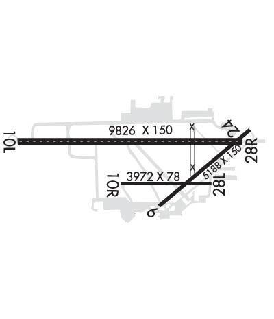
RWY 28R 1000 FT BY 150 FT BLAST PAD
AFRC/ANG: CSTMS/AG/IMG SVC NOT LCTD ON NIAGARA FALLS ARS. SVC AVBL H24.
MILITARY: AFRC/ANG: AIRFIELD OPS SVC 1200-0400Z++ MON-FRI EXC HOL. TWYS A, A1, A2, AND A3 PAINTED MRK FADED AND RETRO-REFLECTIVITY INEFFECTIVE.
INTXN DEPS RWY 24 AT TWY D1 ARE NA.
CAUTION: HEAVY CONCENTRATIONS OF GULLS-BLACKBIRDS-STARLINGS UP TO 5000 AGL ON & INVOF ARPT. BASH PHASE II OPERATIONS AT KIAG MAR-MAY AND SEP-NOV.
TWY A, A1, A2, A3, M & L NON-MOV AREAS.
PILOTS ARE REMINDED TO REVIEW ARPT HOTSPOT INFO BFR TXG FOR DEP & BFR LNDG. SEE TPP ARPT DIAGRAM AND CHART SUPPL SXN ON HOTSPOTS FOR ADDNL INFO.
FOR CD WHEN ATCT CLSD CTC BUFFALO ATCT ON FREQ OR 716-626-6920.
TWY D3 RSTRD TO 12500 LBS OR LESS.
ALL MIL ACFT ONLY OPNS RESTRICTED DURING BIRD WATCH CONDITIONS. MODERATE - TKOF & LDG PERMISSION ONLY WNEN DEP/ARR RTE AVOIDS IDENTIFIED BIRD ACTIVITY; NO LCL IFR/VFR TFC PAT ACTIVITY. SEVERE - TKOF & LDG PHOHIBITED WO OG/CC APPROVAL; CTC COMMAND POST FOR CURRENT BIRD WATCH CONDITIONS.
ALL MIL ACFT ONLY MINIMAL CLASSIFIED MATERIALS AVBL; AIRCREWS SHOULD ARRIVE WITH APPROPRIATE AMOUNT TO COMPLETE THEIR MISSION.
RWY 10R/ 28LCLSD INDEFLY.
RWY 10L/ 28RRWY 28R ROLLOUT END OF RWY- LAST 900 FT NOT GROOVED.
Airport Communications & Frequencies:
ATIS Frequencies:   Hours(local) of Operation: CONTINUOUS
120.8
269.4
NIAGARA Tower Frequencies:   Hours(local) of operation: 0700-2300   
118.5
349.0
NIAGARA Ground Frequencies:
125.3
275.8
Clearance Delivery Frequencies:
119.25
251.1
Emergency Frequencies:
121.5
243.0
CTAF Frequency:
118.500
Unicom Frequency:
122.950
BUFFALO Primary Approach Frequencies:  
126.5
317.6
BUFFALO Primary Departure Frequencies:  
126.5
317.6
Runway Identifications
Runway Identification: 06/24
Length: 5188 ft
Width: 150 ft
Surface: ASPHALT-GOOD CONDITION
Edge lights: Medium Intensity

Treatment: NONE
Weight: PCN 69 /F/B/W/T

 Runway: 06   Runway: 24
Mag heading: 60°Mag heading: 240°
Rwy Slope: .15% UpRwy Slope: -.15% Down
Approach: Approach:
Pattern: Left TrafficPattern: Left Traffic
Markings: NONSTANDARDMarkings: NONSTANDARD
Marking Condition: GOOD; MILITARY ASSAULT LANDING ZONE & NPI MKGS.Marking Condition: GOOD; MILITARY ASSAULT LANDING ZONE & NPI MKGS.
Arresting Dev: Arresting Dev:
Lat & Long: N4306.1  W07856.7Lat. & Long.: N4306.7  W07855.8
Elev: 584.3 ft. MSLElev: 592.2 ft. MSL
TCH: 45 ft. AGLTCH: 48 ft. AGL
Visual Glide Path: 3.00 degreesVisual Glide Path: 3.00 degrees
Displaced Threshold: NoDisplaced Threshold: No
Touchdown Zone: YESTouchdown Zone: YES
Touchdown Elev.: 585.8 feetTouchdown Elev.: 592.3 feet
Visual Glide Slope: 4-Light PAPI on LEFT side of RunwayVisual Glide Slope: 4-Light PAPI on LEFT side of Runway
RVR Equipment: RVR Equipment:
RVV Equipment: NORVV Equipment: NO
Approach Lights: Approach Lights:
REIL: YESREIL: YES
Centerline Lights: NOCenterline Lights: NO
Touchdown lights: NOTouchdown lights: NO
Runway Category: Runway with a Non-precision Approach having visibility minimums greater than 3/4 mileRunway Category: Runway with a Non-precision Approach having visibility minimums greater than 3/4 mile
Declared Distances: TORA:5188' TODA:5188' ASDA:5188' LDA:5188'Declared Distances: TORA:5188' TODA:5188' ASDA:5108' LDA:5108'
Obstructions: TREEObstructions: TREE
Marked: NOT Marked/LightedMarked: NOT Marked/Lighted
Clearance slope: 11:1Clearance slope: 26:1
Obstruction height: 46 feet AGLObstruction height: 59 feet AGL
Dist. from runway: 740 feetDist. from runway: 1750 feet
Centerline offset: 290 right of centerlineCenterline offset: 320 feet right of centerline
Comments: Comments:
Runway Identification: 10L/28R
Length: 9826 ft
Width: 150 ft
Surface: CONCRETE ASPHALT-GOOD CONDITION
Edge lights: High Intensity

Treatment: GROOVED
Weight: PCN 74 /R/B/W/T

 Runway: 10L   Runway: 28R
Mag heading: 100°Mag heading: 280°
Rwy Slope: .00% DownRwy Slope: .00% Up
Approach: Approach: ILS
Pattern: Left TrafficPattern: Left Traffic
Markings: PRECISION INSTRUMENTMarkings: PRECISION INSTRUMENT
Marking Condition: GOODMarking Condition: GOOD
Arresting Dev: Arresting Dev:
Lat & Long: N4306.6  W07858.1Lat. & Long.: N4306.6  W07855.9
Elev: 588.2 ft. MSLElev: 587.9 ft. MSL
TCH: 50 ft. AGLTCH: 67 ft. AGL
Visual Glide Path: 3.00 degreesVisual Glide Path: 2.50 degrees
Displaced Threshold: 700 feetDisplaced Threshold: No
Touchdown Zone: YESTouchdown Zone: YES
Touchdown Elev.: 588.8 feetTouchdown Elev.: 588.3 feet
Visual Glide Slope: 4-BOX VASI ON LEFT SIDE OF RUNWAYVisual Glide Slope: 4-Light PAPI on LEFT side of Runway
RVR Equipment: ROLLOUTRVR Equipment: TOUCHDOWN
RVV Equipment: NORVV Equipment: YES
Approach Lights: Approach Lights: MALSR - 1,400 foot medium intensity approach lighting system with runway alignment indicator lights
REIL: NOREIL: NO
Centerline Lights: YESCenterline Lights: YES
Touchdown lights: NOTouchdown lights: YES
Runway Category: Runway with a Non-precision Approach having visibility minimums greater than 3/4 mileRunway Category: Precision Instrument Runway
Declared Distances: TORA:9829' TODA:10829' ASDA:9829' LDA:9129'Declared Distances: TORA:9829' TODA:10529' ASDA:9129' LDA:9129'
Obstructions: TREEObstructions: TREE
Marked: NOT Marked/LightedMarked: NOT Marked/Lighted
Clearance slope: 12:1; APCH RATIO 29:1 TO DTHR.Clearance slope: 33:1
Obstruction height: 52 feet AGLObstruction height: 37 feet AGL
Dist. from runway: 840 feetDist. from runway: 1425 feet
Centerline offset: 480 right of centerlineCenterline offset: 400 feet left of centerline
Comments: Comments:
Runway Identification: 10R/28L
Length: 3972 ft
Width: 78 ft
Surface: ASPHALT-GOOD CONDITION
Edge lights: Medium Intensity

Treatment: NONE
Weight: PCN 29 /F/C/X/T

 Runway: 10R   Runway: 28L
Mag heading: 100°Mag heading: 280°
Rwy Slope: .04% UpRwy Slope: -.04% Down
Approach: Approach:
Pattern: Left TrafficPattern: Left Traffic
Markings: BASICMarkings: BASIC
Marking Condition: GOODMarking Condition: GOOD
Arresting Dev: Arresting Dev:
Lat & Long: N4306.3  W07857.1Lat. & Long.: N4306.3  W07856.2
Elev: 582.6 ft. MSLElev: 584.2 ft. MSL
TCH: 31 ft. AGLTCH: 30 ft. AGL
Visual Glide Path: 3.26 degreesVisual Glide Path: 3.06 degrees
Displaced Threshold: NoDisplaced Threshold: No
Touchdown Zone: YESTouchdown Zone: YES
Touchdown Elev.: 584.1 feetTouchdown Elev.: 584.8 feet
Visual Glide Slope: 2-Light PAPI on LEFT side of RunwayVisual Glide Slope: 2-Light PAPI on LEFT side of Runway
RVR Equipment: RVR Equipment:
RVV Equipment: NORVV Equipment: NO
Approach Lights: Approach Lights:
REIL: YESREIL: YES
Centerline Lights: NOCenterline Lights: NO
Touchdown lights: NOTouchdown lights: NO
Runway Category: Runway with a Visual ApproachRunway Category: Runway with a Visual Approach
Declared Distances: TORA:3973' TODA:3973' ASDA:3973' LDA:3973'Declared Distances: TORA:3973' TODA:3973' ASDA:3973' LDA:3973'
Obstructions: TREEObstructions: STACK
Marked: NOT Marked/LightedMarked: LIGHTED
Clearance slope: 19:1Clearance slope: 30:1
Obstruction height: 64 feet AGLObstruction height: 59 feet AGL
Dist. from runway: 1420 feetDist. from runway: 2020 feet
Centerline offset: 60 right of centerlineCenterline offset: 120 feet left of centerline
Comments: Comments:
C:31/P: