KIAD

WASHINGTON DULLES INTL
WASHINGTON
DC
Time Zone: Eastern
Lat: N 3856.8
Long: W 07727.6
Elev: 312
Var: +10
Longest Runway: 11500
Clr Del: 135.7
Dept. ATIS: 134.85
Arr. ATIS: 134.85
Ground: 121.9 /121.62
Tower: 120.1/120.25

FBO & Flight Services info for KIAD

FBOs: Update your Fuel Prices

  click here  
Atlantic Aviation is your premier aviation service provider with more than 100 locations in North America, including Hawaii and the Caribbean. We provide standard ground services you'd expect, with a detailed focus on ensuring an unforgettable customer experience.
Ph: 800-926-0150 Fax: 703-661-0152 Freq: 129.77WebsiteE-Mail
Service
Jet
100LL
SAF
MoGas
Full8.627.88    Last Update: 04/18/2024 13:28:40

Self        
Misc. Info: Address: 23411 AUTOPILOT DR.   DULLES, VA 20166

SIGNATUREPh: 703-572-0001 Fax: 703-572-0011 Freq: 131.87
Service
Jet
100LL
SAF
MoGas
Fuel Avail: 24hr. Jet A w/Prist, add $0.06 per gallon.
Full10.0210.33    Last Update: 04/18/2024 12:04  
Self  9.22    
 Address: 23950 WIND SOCK DRIVE, SUITE 2000,   DULLES, VIRGINIA 20166
ATISPh: 571-323-6374
-
-
 
ASOSPh: 703-661-2990
-
-
 
If you are an FBO, call 1-203-262-1700 to update your info or email: FltPlan.Advertising@garmin.com
Advertise your FBO on FltPlan.com
FBOs at nearby airports who want your business:
KHEF


  click here  
AVOID HEAVY TRAFFIC, HIGH PRICES IN DC AREA! Join the others that have recognized low prices, quick service, and professional staff at Manassas. Fully equipped, Beautiful lobby, and NO LANDING FEES. CAA Preferred. Colt, UVair, Mariah, JFI, Mercury, Everest, World.
Ph: 1-703-392-5387WebsiteE-MailFax: 1-703-392-0545Freq: 128.90
KJYO


  click here  
ProJet Aviation (KJYO) is the FBO of choice for seamless access to Washington DC. Just 10 minutes from IAD, and only blocks from the Dulles Toll Rd. ProJet offers easy access to our Nation's Capital. Our full service award winning FBO offers heated hangar space, conference rooms, and a new US Customs facility.
Ph: 1-703-889-8558WebsiteE-MailFax: 1-703-777-1298Freq: 128.95
KHEF


  click here  
Serving the DC metro area for over 30 years. Over 5 acres of Ramp Space. FAA Diamond Award FAA Part 145 Repair Station. Pilots lounge with fully equipped gym and soundproof snooze rooms. Newly constructed 85,000 sq. ft. FBO and Hangar facility.

Duncan Aviation satellite shop located onsite for all your AOG avionics & maintenance needs.
Ph: 1-800-720-5387WebsiteE-MailFax: 1-703-392-5025Freq: 131.62

Runway & Approach Info for KIAD
Rwy
Length
Land Dist**
Approach*
  Rwy
Length
Land Dist**
Approach*
01C
11500x150  11500'          
ILS
 111.30 - 010°  
  
19C
  11500x150  11500'          
ILS
 111.30 - 190°  
01L
9400x150  9400'          
ILS/DME
 110.75 - 010°  
  
19R
  9400x150  9400'          
ILS/DME
 110.75 - 191°  
01R
11500x150  11500'          
ILS/DME
 110.10 - 010°  
  
19L
  11500x150  11500'          
ILS/DME
 110.10 - 190°  
12
10501x150  10501'          
ILS
 109.30 - 120°  
  
30
  10501x150  10501'          
 
 * only ILS, LOC, LDA, and SDF approaches to a specific runway are shown
** For any Declared Landing Distance Available, please see A/FD or Approach plates
Runway Weight Capability (lbs.) Help
Runway IDSingle WheelDouble WheelDouble Tandem WheelDual Double Wheel
01C/19C200,000250,000450,000875,000
01L/19R200,000250,000450,000875,000
01R/19L200,000250,000450,000875,000
12/30200,000250,000450,000875,000
These numbers are Advisory and are not limits.   The Airport Manager should have more accurate Weight Limits
Approach Charts
Approaches    
Current Weather/Notams
Customs Information Send updates to Support@FltPlan.com
Phone 703-661-2800
Fax N/A

Comments 2 hrs advance notice required. Business hrs 0800-2100 Monday-Friday. *Call prior to 1500 on preceding weekday. *For weekend and holiday flights call prior to 1500 on the preceding weekday. Email cbpiadgeneralaviation@cbp.dhs.gov
Database effective 04/18/2024
Airport Diagram of KIAD
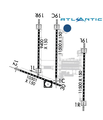
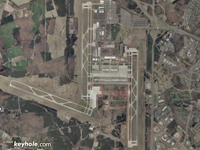
Airport Diagram might not be current.

Facility Name: WASHINGTON DULLES INTL
City Name: WASHINGTON
County: LOUDOUN; LOCATED IN BOTH FAIRFAX COUNTY VA AND LOUDOUN COUNTY VA.
State abbrev: DC
State Name: DIST. OF COLUMBIA
   
Ownership: PUBLICLY OWNED
Use: OPEN TO THE PUBLIC
Owner's Name: METRO WASH ARPT AUTHORITY
Address: 1 AVIATION CIRCLE
 WASHINGTON, DC 20001-6000
Owner's Phone: 703-417-8600
  
Manager's Name: RICHARD GOLINOWSKI
Address: 1 SAARINEN CIRCLE, SAARINEN CENTER MA-210
 DULLES, VA 20166
Phone: 703-572-2730
   
FAA Region: EASTERN
FAA Field Office: DCA


Sunrise / Sunset times for WASHINGTON DULLES INTL

DateSunriseSunset
04/17/24 Wednesday6:2919:50
04/18/24 Thursday6:2819:51
04/19/24 Friday6:2719:52
04/20/24 Saturday6:2519:53
04/21/24 Sunday6:2419:54
04/22/24 Monday6:2219:55
04/23/24 Tuesday6:2119:56
04/24/24 Wednesday6:2019:56
04/25/24 Thursday6:1919:57
04/26/24 Friday6:1719:58
04/27/24 Saturday6:1619:59
04/28/24 Sunday6:1520:00
04/29/24 Monday6:1320:01
04/30/24 Tuesday6:1220:02

Airport Facilities

Airport Attendance ScheduleCONTINUOUS
Airport Status OPERATIONAL (This Status can change at any time - please check NOTAMS)
Airport Lighting Schedule
Airport Storage AvailableTie Downs, Hanger
Extra Services AvailableAir Freight, Avionics, Cargo Handling, Aircraft Sales
Wind IndicatorYES - (lighted)
Control TowerYES
CTAF Frequency
Unicom Frequency122.950
Rotating Beacon ColorWG
Segmented CircleNO
Landing FeeYES

Airport Inspection Data

Airport InspectedFEDERAL - performed by FAA AIRPORTS FIELD PERSONNEL
Inspection Date10/23/2023

Airport Services

Type of Fuel AvailableGrade 100LL, JET A (freeze point -40C)
Airframe Repair ServiceMAJOR
Power Plant Repair ServiceMAJOR

Geographic Data

LatitudeN3856.8
LongitudeW07727.6 (ESTIMATED)
Arpt Elevation312ft (SURVEYED)
Magnetic Variation10W
20 miles Wof WASHINGTON
Traffic Pattern Altitude
Sectional ChartWASHINGTON

Aircraft Data

Operations (Reported)YearlyAvg. Daily
General Aviation Transient 2979782
General Aviation Local 00
Air Taxi 67107184
Commerical 183803504
Commuter 00
Military 4911
Aircraft based on Field
General Aviation Singles 7
General Aviation Multi 0
Jet Aircraft 46
General Aviation Helicopters 0
Military Aircraft 0
Gliders 0
Ultralights 0

FAA Services

FSS on field NO
FSS tie-in LEESBURG
FSS Phone 1-800-WX-BRIEF
Who issues Notams IAD
Notam D service at airport YES
ARTCC Name WASHINGTON

Federal Status

Airport CertificationAIRPORT RECEIVING SCHEDULED AIR CARRIER SERVICE FROM CARRIERS CERTIFICATED BY THE CIVIL AERONAUTICS BOARD
Aircraft Rescue & Firefighting IndexAIRPORT HAS A CERTIFICATE UNDER CFR PART 139
Airport of EntryNo
Custom Landing RightsYES
Joint Civil/MilitaryNo
Military Landing rightsYES

Federal Agreements

NATIONAL PLAN OF INTEGRATED AIRPORT SYSTEMS (NPIAS)
GRANT AGREEMENTS UNDER FAAP/ADAP/AIP
COMPLIANCE WITH ACCESSIBILITY TO THE HANDICAPPED
SURPLUS PROPERTY AGREEMENT UNDER PUBLIC LAW 289
ASSURANCES PURSUANT TO TITLE VI, CIVIL RIGHTS ACT OF 1964

Remarks

TAXILANE 'C' ACTIVE; PUSHBACK CLNCS ON NORTH SIDE OF MIDFIELD TERMINAL ARE ONTO TAXILANE 'D' ONLY UNLESS OTHERWISE AUTH.
ITNRNT ACFT CTC FBO ON 122.95 OR 129.77 FOR SVCS.
ALL AIRCRAFT WITH WINGSPAN EXCEEDING 118 FT ARE RESTRICTED FROM USING TAXILANE A BTN A1 & A5.
RUNUP BLX FOR RWY 30 DSGND AS NON-MOVEMENT AREA.
ALL 180 DEG TURNS OUT OF APRON POSITIONS SHALL BE MADE USING MINIMUM POWER.
LDG FEE. FLIGHT NOTIFICATION SERVICE (ADCUS) AVBL. NOTE: SEE SPECIAL NOTICES --CONTINUOUS POWER FACILITIES.
ASDE-X IN USE. OPERATE TRANSPONDERS WITH ALTITUDE REPORTING MODE AND ADS-B (IF EQUIPPED) ENABLED ON ALL AIRPORT SURFACES.
TWY E1 RESTRICTED TO ACFT WITH A WINGSPAN LESS THAN 79 FT.
B747-8 RESTRICTED TO MAXIMUM TAXI SPEED 17 KTS (20 MPH) ON TWY J.
ENGINE RUN-UPS BTW 2200L & 0700L REQUIRE PRIOR APPROVAL FM ARPT OPS.
RWY 30 DEPARTURES USE UPPER ANTENNA FOR ATC COMMUNICATIONS.
RWY STATUS LGTS ARE IN OPN.
ACR PUSH BACKS & PWR FM ALL APRON PSNS REQUIRE CLNC FM MWAA RAMP TWR.
LARGE FLOCKS OF BIRDS ON & INVOF ARPT/DEER INVOF ARPT.
DURING PERIODS OF ACFT SATURATION LONG TERM PARKING MAY NOT BE AVAILABLE. SERVICES FOR FUEL AND GO ONLY WILL BE AVAILABLE.
FLIGHT TRAINING BETWEEN 2200-0700 IS PROHIBITED.
Airport Communications & Frequencies:
ATIS Frequencies:   Hours(local) of Operation: CONTINUOUS
134.85
DULLES Tower Frequencies:   Hours(local) of operation: CONTINUOUS   
120.1 ;RWY 01R/19L
120.25 ;RWY 01C/19C
134.425 ;RWY 01L/19R, RWY 12/30
317.8 ;RWY 01R/19L
348.6 ;RWY 01C/19C
348.6 ;RWY 01L/19R, RWY 12/30
DULLES Ground Frequencies:
121.625 ;WEST
121.9 ;EAST
317.8 ;EAST
348.6 ;WEST
Clearance Delivery Frequencies:
135.7
317.8
Emergency Frequencies:
121.5
243.0
Unicom Frequency:
122.950
Remarks
  • ASR RADAR UNAVBL ABV 15000 FT.
  • ARRIVALS MAY BE EXTENDED OUTSIDE OF CLASS B.
  • POTOMAC Primary Approach Frequencies:  
    120.45 241-330
    126.1 331-090
    128.525 091-240
    306.925 091-330
    338.25 331-090
    POTOMAC Primary Departure Frequencies:  
    125.05 300-010
    126.65 190-300
    350.2
    Class B Frequencies:
    120.45 241-330
    126.1 331-090
    128.525 091-240
    306.925 091-330
    338.25 331-090
    Runway Identifications
    Runway Identification: 01C/19C
    Length: 11500 ft
    Width: 150 ft
    Surface: CONCRETE
    Edge lights: High Intensity

    Treatment: GROOVED
    Weight: PCN 81 /R/C/W/T

     Runway: 01C   Runway: 19C
    Mag heading: 11°Mag heading: 191°
    Rwy Slope: -.15% DownRwy Slope: .15% Up
    Approach: ILSApproach: ILS
    Pattern: Left TrafficPattern: Left Traffic
    Markings: PRECISION INSTRUMENTMarkings: PRECISION INSTRUMENT
    Marking Condition: GOODMarking Condition: GOOD
    Arresting Dev: Arresting Dev:
    Lat & Long: N3856.3  W07727.6Lat. & Long.: N3858.2  W07727.6
    Elev: 286.1 ft. MSLElev: 268.6 ft. MSL
    TCH: 70 ft. AGLTCH: 72 ft. AGL
    Visual Glide Path: 3.00 degreesVisual Glide Path: 3.00 degrees
    Displaced Threshold: NoDisplaced Threshold: No
    Touchdown Zone: YESTouchdown Zone: YES
    Touchdown Elev.: 286.1 feetTouchdown Elev.: 271.8 feet
    Visual Glide Slope: 4-Light PAPI on LEFT side of RunwayVisual Glide Slope: 4-Light PAPI on RIGHT side of Runway
    RVR Equipment: TOUCHDOWN-MIDFIELD-ROLLOUTRVR Equipment: TOUCHDOWN-MIDFIELD-ROLLOUT
    RVV Equipment: NORVV Equipment: NO
    Approach Lights: MALSR - 1,400 foot medium intensity approach lighting system with runway alignment indicator lightsApproach Lights: ALSF2 - standard 2,400 foot high intensity approach lighting system with sequenced flashers, Category II or III
    REIL: NOREIL: NO
    Centerline Lights: YESCenterline Lights: YES
    Touchdown lights: YESTouchdown lights: YES
    Runway Category: Precision Instrument RunwayRunway Category: Precision Instrument Runway
    Declared Distances: TORA:11500' TODA:11500' ASDA:11500' LDA:11500'Declared Distances: TORA:11500' TODA:11500' ASDA:11500' LDA:11089'
    Runway Identification: 01L/19R
    Length: 9400 ft
    Width: 150 ft
    Surface: CONCRETE
    Edge lights: High Intensity

    Treatment: GROOVED
    Weight: PCN 81 /R/C/W/T

     Runway: 01L   Runway: 19R
    Mag heading: 11°Mag heading: 191°
    Rwy Slope: -.20% DownRwy Slope: .20% Up
    Approach: ILS/DMEApproach: ILS/DME
    Pattern: Left TrafficPattern: Left Traffic
    Markings: PRECISION INSTRUMENTMarkings: PRECISION INSTRUMENT
    Marking Condition: GOODMarking Condition: GOOD
    Arresting Dev: Arresting Dev:
    Lat & Long: N3856.7  W07728.5Lat. & Long.: N3858.2  W07728.5
    Elev: 296.0 ft. MSLElev: 277.0 ft. MSL
    TCH: 70 ft. AGLTCH: 70 ft. AGL
    Visual Glide Path: 3.00 degreesVisual Glide Path: 3.00 degrees
    Displaced Threshold: NoDisplaced Threshold: No
    Touchdown Zone: YESTouchdown Zone: YES
    Touchdown Elev.: 296.0 feetTouchdown Elev.: 278.3 feet
    Visual Glide Slope: 4-Light PAPI on LEFT side of RunwayVisual Glide Slope: 4-Light PAPI on LEFT side of Runway
    RVR Equipment: TOUCHDOWN-MIDFIELD-ROLLOUTRVR Equipment: TOUCHDOWN-MIDFIELD-ROLLOUT
    RVV Equipment: NORVV Equipment: NO
    Approach Lights: ALSF2 - standard 2,400 foot high intensity approach lighting system with sequenced flashers, Category II or IIIApproach Lights: ALSF2 - standard 2,400 foot high intensity approach lighting system with sequenced flashers, Category II or III
    REIL: NOREIL: NO
    Centerline Lights: YESCenterline Lights: YES
    Touchdown lights: YESTouchdown lights: YES
    Runway Category: Precision Instrument RunwayRunway Category: Precision Instrument Runway
    Declared Distances: TORA:9400' TODA:9400' ASDA:9400' LDA:9400'Declared Distances: TORA:9400' TODA:9400' ASDA:9400' LDA:9400'
    Runway Identification: 01R/19L
    Length: 11500 ft
    Width: 150 ft
    Surface: CONCRETE-GOOD CONDITION
    Edge lights: High Intensity

    Treatment: GROOVED
    Weight: PCN 81 /R/C/W/T

     Runway: 01R   Runway: 19L
    Mag heading: 11°Mag heading: 191°
    Rwy Slope: -.16% DownRwy Slope: .16% Up
    Approach: ILS/DMEApproach: ILS/DME
    Pattern: Left TrafficPattern: Left Traffic
    Markings: PRECISION INSTRUMENTMarkings: PRECISION INSTRUMENT
    Marking Condition: GOODMarking Condition: GOOD
    Arresting Dev: Arresting Dev:
    Lat & Long: N3855.4  W07726.2Lat. & Long.: N3857.3  W07726.2
    Elev: 311.7 ft. MSLElev: 293.0 ft. MSL
    TCH: 72 ft. AGLTCH: 75 ft. AGL
    Visual Glide Path: 3.00 degreesVisual Glide Path: 3.00 degrees
    Displaced Threshold: NoDisplaced Threshold: No
    Touchdown Zone: YESTouchdown Zone: YES
    Touchdown Elev.: 312.3 feetTouchdown Elev.: 302.0 feet
    Visual Glide Slope: 4-Light PAPI on RIGHT side of RunwayVisual Glide Slope: 4-Light PAPI on LEFT side of Runway
    RVR Equipment: TOUCHDOWN-MIDFIELD-ROLLOUTRVR Equipment: TOUCHDOWN-MIDFIELD-ROLLOUT
    RVV Equipment: NORVV Equipment: NO
    Approach Lights: ALSF2 - standard 2,400 foot high intensity approach lighting system with sequenced flashers, Category II or IIIApproach Lights: ALSF2 - standard 2,400 foot high intensity approach lighting system with sequenced flashers, Category II or III
    REIL: NOREIL: NO
    Centerline Lights: YESCenterline Lights: YES
    Touchdown lights: YESTouchdown lights: NO
    Runway Category: Precision Instrument RunwayRunway Category: Precision Instrument Runway
    Declared Distances: TORA:11500' TODA:11500' ASDA:11500' LDA:11500'Declared Distances: TORA:11500' TODA:11500' ASDA:11500' LDA:11500'
    Obstructions: Obstructions: POLE
    Marked: Marked: NOT Marked/Lighted
    Clearance slope: 50:1Clearance slope: 44:1
    Obstruction height: Obstruction height: 38 feet AGL
    Dist. from runway: Dist. from runway: 1900 feet
    Centerline offset: Centerline offset: 720 feet right of centerline
    Comments: Comments:
    Runway Identification: 12/30
    Length: 10501 ft
    Width: 150 ft
    Surface: CONCRETE-GOOD CONDITION
    Edge lights: High Intensity

    Treatment: GROOVED
    Weight: PCN 81 /R/C/W/T

     Runway: 12   Runway: 30
    Mag heading: 121°Mag heading: 301°
    Rwy Slope: -.21% DownRwy Slope: .21% Up
    Approach: ILSApproach:
    Pattern: Left TrafficPattern: Left Traffic
    Markings: PRECISION INSTRUMENTMarkings: PRECISION INSTRUMENT
    Marking Condition: GOODMarking Condition: GOOD
    Arresting Dev: Arresting Dev:
    Lat & Long: N3856.6  W07729.4Lat. & Long.: N3856.0  W07727.4
    Elev: 309.9 ft. MSLElev: 287.6 ft. MSL
    TCH: 66 ft. AGLTCH: 84 ft. AGL
    Visual Glide Path: 3.00 degreesVisual Glide Path: 3.00 degrees
    Displaced Threshold: NoDisplaced Threshold: No
    Touchdown Zone: YESTouchdown Zone: YES
    Touchdown Elev.: 309.9 feetTouchdown Elev.: 287.7 feet
    Visual Glide Slope: 4-Light PAPI on RIGHT side of RunwayVisual Glide Slope: 4-Light PAPI on LEFT side of Runway
    RVR Equipment: TOUCHDOWN-ROLLOUTRVR Equipment: TOUCHDOWN-ROLLOUT
    RVV Equipment: NORVV Equipment: NO
    Approach Lights: MALSR - 1,400 foot medium intensity approach lighting system with runway alignment indicator lightsApproach Lights:
    REIL: NOREIL: YES
    Centerline Lights: YESCenterline Lights: YES
    Touchdown lights: YESTouchdown lights: NO
    Runway Category: Precision Instrument RunwayRunway Category: Runway with a Visual Approach
    Declared Distances: TORA:10501' TODA:10501' ASDA:10501' LDA:10501'Declared Distances: TORA:10501' TODA:10501' ASDA:10501' LDA:10501'
    C:391/P: