Click here for more info on on SMS!

KI95

HARDIN COUNTY
KENTON
OH
Time Zone: Eastern
Lat: N 4036.6
Long: W 08338.7
Elev: 1029
Var: +06
Longest Runway: 4797
CTAF: 122.8

FBO & Flight Services info for KI95

FBOs: Update your Fuel Prices

HARDIN AERO INCPh: 419-673-9542
-
Freq: 122.8

If you are an FBO, call 1-203-262-1700 to update your info or email: FltPlan.Advertising@garmin.com
Advertise your FBO on FltPlan.com

Runway & Approach Info for KI95
Rwy
Length
Land Dist**
Approach*
  Rwy
Length
Land Dist**
Approach*
04
4797x75  4797'          
 
  
22
  4797x75  4797'          
 
 * only ILS, LOC, LDA, and SDF approaches to a specific runway are shown
** For any Declared Landing Distance Available, please see A/FD or Approach plates
Runway Weight Capability (lbs.) Help
Runway IDSingle WheelDouble WheelDouble Tandem WheelDual Double Wheel
04/2219,000N/AN/AN/A
These numbers are Advisory and are not limits.   The Airport Manager should have more accurate Weight Limits
Approach Charts
Approaches    
Current Weather/Notams
Customs Information Send updates to Support@FltPlan.com
Customs Not Available
Database effective 05/16/2024
Airport Diagram of KI95
Airport Diagram might not be current.

Facility Name: HARDIN COUNTY
City Name: KENTON
County: HARDIN
State abbrev: OH
State Name: OHIO
   
Ownership: PUBLICLY OWNED
Use: OPEN TO THE PUBLIC
Owner's Name: HARDIN CO ARPT AUTH
Address: 20783 COUNTY ROAD 200
 KENTON, OH 43326
Owner's Phone: 567-674-9355
  
Manager's Name: ED MCCORMICK
Address: 13975 COUNTY ROAD 135
 KENTON, OH 43326-9304
Phone: 419-673-9542
   
FAA Region: GREAT LAKES
FAA Field Office: DET


Sunrise / Sunset times for HARDIN COUNTY

DateSunriseSunset
05/06/24 Monday6:2620:36
05/07/24 Tuesday6:2520:37
05/08/24 Wednesday6:2420:38
05/09/24 Thursday6:2320:39
05/10/24 Friday6:2220:40
05/11/24 Saturday6:2120:41
05/12/24 Sunday6:2020:42
05/13/24 Monday6:1920:43
05/14/24 Tuesday6:1820:44
05/15/24 Wednesday6:1720:45
05/16/24 Thursday6:1620:46
05/17/24 Friday6:1520:47
05/18/24 Saturday6:1420:48
05/19/24 Sunday6:1420:49

Airport Facilities

Airport Attendance ScheduleSAT-SUN 0900-1700, MON-FRI 0900-1800; UNATNDD MAJOR HOLS.
Airport Status OPERATIONAL (This Status can change at any time - please check NOTAMS)
Airport Lighting ScheduleACTVT MIRL RWY 04/22 - 3 CLICKS CTAF WI 3 SECS.
Airport Storage AvailableTie Downs, Hanger
Extra Services AvailableNONE
Wind IndicatorYES - (lighted)
Control TowerNO
CTAF Frequency122.800
Unicom Frequency122.800
Rotating Beacon ColorWG
Segmented CircleNO
Landing FeeNO

Airport Inspection Data

Airport InspectedSTATE - performed by STATE AERONAUTICAL PERSONNEL
Inspection Date06/22/2022

Airport Services

Type of Fuel AvailableGrade 100LL, JET A-1 (icing inhibitor, freeze point -50C)
Airframe Repair ServiceMAJOR
Power Plant Repair ServiceMAJOR

Geographic Data

LatitudeN4036.6
LongitudeW08338.7 (ESTIMATED)
Arpt Elevation1029ft (SURVEYED)
Magnetic Variation06W
3 miles SWof KENTON
Traffic Pattern Altitude
Sectional ChartDETROIT

Aircraft Data

Operations (Reported)YearlyAvg. Daily
General Aviation Transient 29858
General Aviation Local 367510
Air Taxi 6302
Commerical 00
Commuter 00
Military 520
Aircraft based on Field
General Aviation Singles 16
General Aviation Multi 0
Jet Aircraft 0
General Aviation Helicopters 0
Military Aircraft 0
Gliders 0
Ultralights 0

FAA Services

FSS on field NO
FSS tie-in DAYTON
FSS Phone 1-800-WX-BRIEF
Who issues Notams DAY
Notam D service at airport YES
ARTCC Name INDIANAPOLIS

Federal Status

Airport Certification
Aircraft Rescue & Firefighting IndexNone
Airport of EntryNo
Custom Landing RightsNo
Joint Civil/MilitaryNo
Military Landing rightsNo

Federal Agreements

NATIONAL PLAN OF INTEGRATED AIRPORT SYSTEMS (NPIAS)

Remarks

DEER & BIRDS ON & INVOF ARPT.
FOR CD CTC COLUMBUS APCH AT 614-338-8537.
Airport Communications & Frequencies:
CTAF Frequency:
122.800
Unicom Frequency:
122.800
COLUMBUS Primary Approach Frequencies:  
134.45
323.15
COLUMBUS Primary Departure Frequencies:  
134.45
323.15
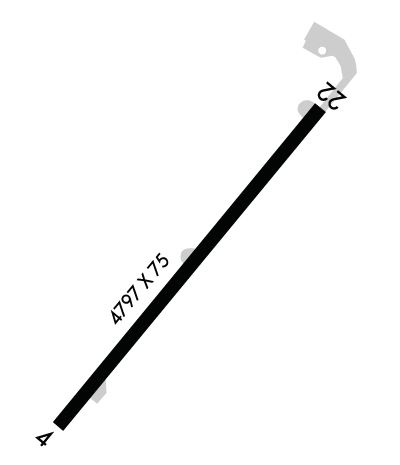
Runway Identifications
Runway Identification: 04/22
Length: 4797 ft
Width: 75 ft
Surface: ASPHALT-GOOD CONDITION
Edge lights: Medium Intensity

Treatment: NONE

 Runway: 04   Runway: 22
Mag heading: 46°Mag heading: 226°
Rwy Slope: -.53% DownRwy Slope: .53% Up
Approach: Approach:
Pattern: Right TrafficPattern: Left Traffic
Markings: NONPRECISION INSTRUMENTMarkings: NONPRECISION INSTRUMENT
Marking Condition: GOODMarking Condition: GOOD
Arresting Dev: Arresting Dev:
Lat & Long: N4036.3  W08339.0Lat. & Long.: N4036.9  W08338.3
Elev: 1029.0 ft. MSLElev: 1003.6 ft. MSL
TCH: TCH:
Visual Glide Path: Visual Glide Path:
Displaced Threshold: NoDisplaced Threshold: No
Touchdown Zone: YESTouchdown Zone: YES
Touchdown Elev.: 1029.0 feetTouchdown Elev.: 1022.8 feet
Visual Glide Slope: Visual Glide Slope:
RVR Equipment: RVR Equipment:
RVV Equipment: NORVV Equipment: NO
Approach Lights: Approach Lights:
REIL: NOREIL: NO
Centerline Lights: NOCenterline Lights: NO
Touchdown lights: NOTouchdown lights: NO
Runway Category: Runway with a Non-precision ApproachRunway Category: Runway with a Non-precision Approach
Declared Distances: Declared Distances:
Obstructions: TREEObstructions: ACFT
Marked: NOT Marked/LightedMarked: NOT Marked/Lighted
Clearance slope: 17:1Clearance slope:
Obstruction height: 93 feet AGLObstruction height: 30 feet AGL
Dist. from runway: 1862 feetDist. from runway: 201 feet
Centerline offset: 316 right of centerlineCenterline offset: 220 feet right of centerline
Comments: Comments: 30 FT TWY, 0-200 FT DIST, 220-250 FT R.
C:/P: