Approach Charts
| FltPlan does not have IFR approach charts available for KI71. |
Current Weather/Notams (Metars, TAFs, Notams, NWS Forecast, PIREPS, and nearby weather)
Customs Information Send updates to Support@FltPlan.com
Customs Not Available
Database effective 04/18/2024
Airport Diagram might not be current.
|
| Facility Name: | MORGAN COUNTY |
| City Name: | MC CONNELSVILLE |
| County: | MORGAN |
| State abbrev: | OH |
| State Name: | OHIO |
| | |
| Ownership: | PUBLICLY OWNED |
| Use: | OPEN TO THE PUBLIC |
| Owner's Name: | MORGAN COUNTY AIRPORT AUTH |
| Address: | 995 E AIRPORT RD NE |
| | MCCONNELSVILLE, OH 43756-9323 |
| Owner's Phone: | 334-447-0624 |
| | |
| Manager's Name: | KURT JOHNSON |
| Address: | 995 E AIRPORT RD NE |
| | MCCONNELLSVILLE, OH 43756-9323 |
| Phone: | 334-447-0624; EMERG TEL 740-962-3333-SHERIFF OFC. |
| | |
| FAA Region: | GREAT LAKES |
| FAA Field Office: | DET |
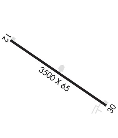
Runway Identifications
Runway Identification: 12/30Length: 3500 ft
Width: 65 ft
Surface: ASPHALT-FAIR CONDITION
Edge lights: Medium IntensityTreatment: NONE
| | Runway: 12 | | Runway: 30 |
| Mag heading: | 125° | Mag heading: | 305° |
| Rwy Slope: | .00% | Rwy Slope: | .00% |
| Approach: | | Approach: | |
| Pattern: | Left Traffic | Pattern: | Left Traffic |
| Markings: | BASIC | Markings: | BASIC |
| Marking Condition: | POOR; FADED. | Marking Condition: | POOR; FADED. |
| Arresting Dev: | | Arresting Dev: | |
| Lat & Long: | N3939.4 W08148.5 | Lat. & Long.: | N3939.1 W08147.9 |
| Elev: | 1000.0 ft. MSL | Elev: | 1000.0 ft. MSL |
| TCH: | | TCH: | |
| Visual Glide Path: | | Visual Glide Path: | |
| Displaced Threshold: | 350 feet | Displaced Threshold: | No |
| Touchdown Zone: | NO | Touchdown Zone: | NO |
| Touchdown Elev.: | | Touchdown Elev.: | |
| Visual Glide Slope: | | Visual Glide Slope: | |
| RVR Equipment: | | RVR Equipment: | |
| RVV Equipment: | NO | RVV Equipment: | NO |
| Approach Lights: | | Approach Lights: | |
| REIL: | NO | REIL: | NO |
| Centerline Lights: | NO | Centerline Lights: | NO |
| Touchdown lights: | NO | Touchdown lights: | NO |
| Runway Category: | Runway with a Visual Approach | Runway Category: | Runway with a Visual Approach |
| Declared Distances: | | Declared Distances: | |
| Obstructions: | ROAD | Obstructions: | HILL |
| Marked: | LIGHTED | Marked: | NOT Marked/Lighted |
| Clearance slope: | 1:1; APCH SLP 19:1 TO DTHR DUE TO 10 FT PVT ROAD, 0 FT DIST, 58 FT R; APCH SLP 0:1 DUE TO 20 FT HILL, 0 FT DIST, 96 FT L. | Clearance slope: | 8:1 |
| Obstruction height: | 25 feet AGL | Obstruction height: | 6 feet AGL |
| Dist. from runway: | 225 feet | Dist. from runway: | 250 feet |
| Centerline offset: | 125 left of centerline | Centerline offset: | 125 feet right of centerline |
| Comments: | +12 FT TRRN, 0 FT DIST, 125 FT L. | Comments: | +7 FT TRRN, 0 FT DIST, 125 FT R. |

