Current Weather/Notams (Metars, TAFs, Notams, NWS Forecast, PIREPS, and nearby weather)
Customs Information Send updates to Support@FltPlan.com
Customs Not Available
Database effective 05/16/2024
Airport Diagram might not be current.
|
| Facility Name: | CLERMONT COUNTY |
| City Name: | BATAVIA |
| County: | CLERMONT |
| State abbrev: | OH |
| State Name: | OHIO |
| | |
| Ownership: | PUBLICLY OWNED |
| Use: | OPEN TO THE PUBLIC |
| Owner's Name: | CLERMONT CO COMSNRS |
| Address: | 101 E MAIN ST |
| | BATAVIA, OH 45103-2957 |
| Owner's Phone: | 513-735-9500 |
| | |
| Manager's Name: | CHUCK GALLAGHER |
| Address: | 2001 SPORTYS DR |
| | BATAVIA, OH 45103-9719 |
| Phone: | 513-735-9100; EXTN 227. |
| | |
| FAA Region: | GREAT LAKES |
| FAA Field Office: | DET |
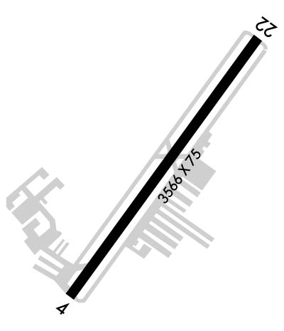
Runway Identifications
Runway Identification: 04/22Length: 3566 ft
Width: 75 ft
Surface: ASPHALT-FAIR CONDITION
Edge lights: Medium IntensityTreatment: NONE
| | Runway: 04 | | Runway: 22 |
| Mag heading: | 40° | Mag heading: | 220° |
| Rwy Slope: | -.85% Down | Rwy Slope: | .85% Up |
| Approach: | | Approach: | |
| Pattern: | Left Traffic | Pattern: | Left Traffic |
| Markings: | NONPRECISION INSTRUMENT | Markings: | NONPRECISION INSTRUMENT |
| Marking Condition: | GOOD | Marking Condition: | GOOD |
| Arresting Dev: | | Arresting Dev: | |
| Lat & Long: | N3904.5 W08412.8 | Lat. & Long.: | N3904.9 W08412.4 |
| Elev: | 843.1 ft. MSL | Elev: | 812.7 ft. MSL |
| TCH: | 16 ft. AGL | TCH: | 29 ft. AGL |
| Visual Glide Path: | 4.00 degrees | Visual Glide Path: | 3.00 degrees |
| Displaced Threshold: | 396 feet | Displaced Threshold: | No |
| Touchdown Zone: | YES | Touchdown Zone: | YES |
| Touchdown Elev.: | 840.4 feet | Touchdown Elev.: | 839.3 feet |
| Visual Glide Slope: | 2-Light PAPI on LEFT side of Runway | Visual Glide Slope: | 2-Light PAPI on LEFT side of Runway |
| RVR Equipment: | | RVR Equipment: | |
| RVV Equipment: | NO | RVV Equipment: | NO |
| Approach Lights: | | Approach Lights: | |
| REIL: | YES | REIL: | YES |
| Centerline Lights: | NO | Centerline Lights: | NO |
| Touchdown lights: | NO | Touchdown lights: | NO |
| Runway Category: | Runway with a Non-precision Approach | Runway Category: | Runway with a Non-precision Approach |
| Declared Distances: | | Declared Distances: | |
| Obstructions: | ROAD | Obstructions: | TREES |
| Marked: | NOT Marked/Lighted | Marked: | NOT Marked/Lighted |
| Clearance slope: | 0:1 APCH SLOPE TO DTHR DUE TO 15 FT ROAD 225 FT R. | Clearance slope: | 20:1 |
| Obstruction height: | 15 feet AGL | Obstruction height: | 56 feet AGL |
| Dist. from runway: | 201 feet | Dist. from runway: | 1353 feet |
| Centerline offset: | 225 right of centerline | Centerline offset: | 396 feet left of centerline |
| Comments: | 13 FT FENCE, 0-200 FT DIST, 206 FT R; 15 FT ROAD, 0-200 FT DIST, 225 FT R. | Comments: | 3 FT CONC PIPE, 4 FT DIAM, 175 FT DIST, 220 FT R. |

