Click here for more info on on SMS!

KI68

LEBANON-WARREN COUNTY
LEBANON
OH
Time Zone: Eastern
Lat: N 3927.7
Long: W 08415.1
Elev: 898
Var: +05
Longest Runway: 4502
Clr Del: 119.4
AWOS: 120.55
CTAF: 123.07

FBO & Flight Services info for KI68

FBOs: Update your Fuel Prices
Providing high quality fuel and services to you and your customers, from Phillips 66 Aviation.
Ph: 513-932-7966
-
Freq: 123.07WebsiteE-Mail
Service
Jet
100LL
SAF
MoGas
Fuel Avail: PRIST PREMIXED. ASSISTED SELF-SERVE
Full4.965.61    Caution: Fuel prices have not been updated in 34 days.
Last Update: 03/16/2024 15:48

Self4.965.51    
Misc. Info: Address: 2460 GREENTREE RD   LEBANON, OH 45036

AWOSPh: 513-934-5500
-
Freq: 120.55  
If you are an FBO, call 1-203-262-1700 to update your info or email: FltPlan.Advertising@garmin.com
Advertise your FBO on FltPlan.com

Runway & Approach Info for KI68
Rwy
Length
Land Dist**
Approach*
  Rwy
Length
Land Dist**
Approach*
01
4502x75  4407'          
 
  
19
  4502x75  4502'          
 
 * only ILS, LOC, LDA, and SDF approaches to a specific runway are shown
** For any Declared Landing Distance Available, please see A/FD or Approach plates
Runway Weight Capability (lbs.) Help
Runway IDSingle WheelDouble WheelDouble Tandem WheelDual Double Wheel
01/19N/AN/AN/AN/A
These numbers are Advisory and are not limits.   The Airport Manager should have more accurate Weight Limits
Approach Charts
Approaches    
Current Weather/Notams
Customs Information Send updates to Support@FltPlan.com
Customs Not Available
Database effective 04/18/2024
Airport Diagram of KI68
Airport Diagram might not be current.

Facility Name: WARREN COUNTY/JOHN LANE FLD
City Name: LEBANON
County: WARREN
State abbrev: OH
State Name: OHIO
   
Ownership: PUBLICLY OWNED
Use: OPEN TO THE PUBLIC
Owner's Name: WARREN COUNTY AIRPORT AUTHORITY
Address: 2460 GREENTREE RD
 LEBANON, OH 45036-9604
Owner's Phone: 513-932-7966
  
Manager's Name: ALAN WOLFSON; ALAN.WOLFSON@FUSE.NET.
Address: 2460 GREENTREE RD
 LEBANON, OH 45036-9604
Phone: 513-932-7966
   
FAA Region: GREAT LAKES
FAA Field Office: DET


Sunrise / Sunset times for WARREN COUNTY/JOHN LANE FLD

DateSunriseSunset
04/18/24 Thursday6:5420:19
04/19/24 Friday6:5320:20
04/20/24 Saturday6:5220:21
04/21/24 Sunday6:5020:22
04/22/24 Monday6:4920:23
04/23/24 Tuesday6:4720:24
04/24/24 Wednesday6:4620:25
04/25/24 Thursday6:4520:26
04/26/24 Friday6:4320:27
04/27/24 Saturday6:4220:27
04/28/24 Sunday6:4120:28
04/29/24 Monday6:4020:29
04/30/24 Tuesday6:3820:30
05/01/24 Wednesday6:3720:31

Airport Facilities

Airport Attendance Schedule7 Days A Week 0730-2200
Airport Status OPERATIONAL (This Status can change at any time - please check NOTAMS)
Airport Lighting ScheduleACTVT REIL RWY 01 & 19; MIRL RWY 01/19 - 7 CLICKS CTAF.
Airport Storage AvailableTie Downs
Extra Services AvailableFlight Instruction, Aircraft Rental
Wind IndicatorYES - (unlit)
Control TowerNO
CTAF Frequency123.075
Unicom Frequency123.075
Rotating Beacon ColorWG
Segmented CircleNO
Landing FeeNO

Airport Inspection Data

Airport InspectedSTATE - performed by STATE AERONAUTICAL PERSONNEL
Inspection Date08/04/2021

Airport Services

Type of Fuel AvailableGrade 100LL, JET A (freeze point -40C); -A JET A FULL SVC DURG ATNDD HRS.; -10100LL FULL SVC DURG ATNDD HRS; AVBL H24 SELF SVC VIA CREDIT CARD.
Airframe Repair ServiceMAJOR
Power Plant Repair ServiceMAJOR

Geographic Data

LatitudeN3927.7
LongitudeW08415.1 (ESTIMATED)
Arpt Elevation897ft (SURVEYED)
Magnetic Variation05W
3 miles NWof LEBANON
Traffic Pattern Altitude
Sectional ChartCINCINNATI

Aircraft Data

Operations (Reported)YearlyAvg. Daily
General Aviation Transient 600016
General Aviation Local 2500068
Air Taxi 5001
Commerical 00
Commuter 00
Military 500
Aircraft based on Field
General Aviation Singles 80
General Aviation Multi 10
Jet Aircraft 1
General Aviation Helicopters 4
Military Aircraft 0
Gliders 0
Ultralights 0

FAA Services

FSS on field NO
FSS tie-in DAYTON
FSS Phone 1-800-WX-BRIEF
Who issues Notams DAY
Notam D service at airport YES
ARTCC Name INDIANAPOLIS

Federal Status

Airport Certification
Aircraft Rescue & Firefighting IndexNone
Airport of EntryNo
Custom Landing RightsNo
Joint Civil/MilitaryNo
Military Landing rightsNo

Federal Agreements

NATIONAL PLAN OF INTEGRATED AIRPORT SYSTEMS (NPIAS)

Remarks

PAEW ADJ RWY & TWY INDEFLY.
FOR CD CTC COLUMBUS APCH AT 614-338-8537.
HOT AIR BLN OPS PSBL AT SR AND 1-2 HRS PRIOR TO SS.
RWY 01 CALM WIND RWY.
Airport Communications & Frequencies:
Clearance Delivery Frequencies:
119.4
CTAF Frequency:
123.075
Unicom Frequency:
123.075
COLUMBUS Primary Approach Frequencies:  
118.85
269.275
COLUMBUS Primary Departure Frequencies:  
118.85
269.275
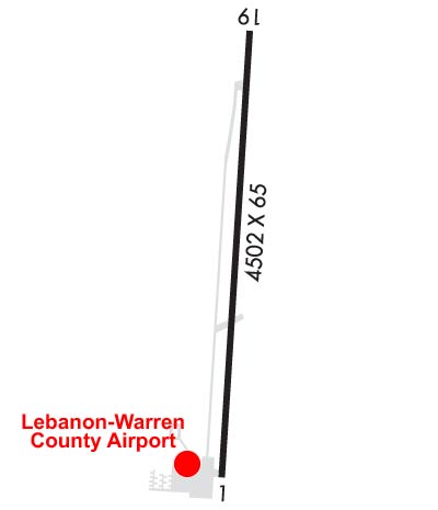
Runway Identifications
Runway Identification: 01/19
Length: 4502 ft
Width: 75 ft
Surface: ASPHALT
Edge lights: Medium Intensity

Treatment: GROOVED

 Runway: 01   Runway: 19
Mag heading: Mag heading: 189°
Rwy Slope: .32% UpRwy Slope: -.32% Down
Approach: Approach:
Pattern: Left TrafficPattern: Left Traffic
Markings: NONPRECISION INSTRUMENTMarkings: NONPRECISION INSTRUMENT
Marking Condition: GOODMarking Condition: GOOD
Arresting Dev: Arresting Dev:
Lat & Long: N3927.4  W08415.1Lat. & Long.: N3928.1  W08415.1
Elev: 883.5 ft. MSLElev: 897.9 ft. MSL
TCH: 33 ft. AGLTCH: 35 ft. AGL
Visual Glide Path: 3.20 degreesVisual Glide Path: 3.50 degrees
Displaced Threshold: 95 feetDisplaced Threshold: No
Touchdown Zone: YESTouchdown Zone: YES
Touchdown Elev.: 892.8 feetTouchdown Elev.: 897.9 feet
Visual Glide Slope: 4-Light PAPI on RIGHT side of RunwayVisual Glide Slope: 4-Light PAPI on LEFT side of Runway
RVR Equipment: RVR Equipment:
RVV Equipment: NORVV Equipment: NO
Approach Lights: Approach Lights:
REIL: YESREIL: YES
Centerline Lights: NOCenterline Lights: NO
Touchdown lights: NOTouchdown lights: NO
Runway Category: Runway with a Non-precision ApproachRunway Category: Runway with a Non-precision Approach
Declared Distances: Declared Distances:
Obstructions: ROADObstructions: TREES
Marked: NOT Marked/LightedMarked: NOT Marked/Lighted
Clearance slope: 18:1; OBST CLNC SLP 25:1 TO DTHR.Clearance slope: 16:1
Obstruction height: 15 feet AGLObstruction height: 67 feet AGL
Dist. from runway: 471 feetDist. from runway: 1335 feet
Centerline offset: 282 left of centerlineCenterline offset: 86 feet left of centerline
Comments: Comments:
C:5/P: