Current Weather/Notams (Metars, TAFs, Notams, NWS Forecast, PIREPS, and nearby weather)
Customs Information Send updates to Support@FltPlan.com
Customs Not Available
Database effective 04/18/2024
Airport Diagram might not be current.
|
| Facility Name: | CINCINNATI WEST |
| City Name: | HARRISON |
| County: | HAMILTON |
| State abbrev: | OH |
| State Name: | OHIO |
| | |
| Ownership: | PUBLICLY OWNED |
| Use: | OPEN TO THE PUBLIC |
| Owner's Name: | CINCINNATI STATE TECH & CMTY COLL |
| Address: | 3520 CENTRAL PKWY |
| | CINCINNATI, OH 45223-2612 |
| Owner's Phone: | 513-569-4956 |
| | |
| Manager's Name: | WILL BERNINGER |
| Address: | 10004 WEST RD |
| | HARRISON, OH 45030-1955 |
| Phone: | 513-367-1201; OR 513-367-5070. |
| | |
| FAA Region: | GREAT LAKES |
| FAA Field Office: | DET |
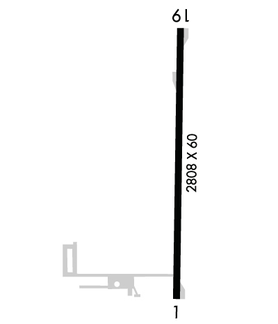
Runway Identifications
Runway Identification: 01/19Length: 2808 ft
Width: 60 ft
Surface: ASPHALT-GOOD CONDITION
Edge lights: Medium IntensityTreatment: NONE
| | Runway: 01 | | Runway: 19 |
| Mag heading: | 5° | Mag heading: | 185° |
| Rwy Slope: | -.03% Down | Rwy Slope: | .03% Up |
| Approach: | | Approach: | |
| Pattern: | Left Traffic | Pattern: | Left Traffic |
| Markings: | NONPRECISION INSTRUMENT | Markings: | NONPRECISION INSTRUMENT |
| Marking Condition: | GOOD | Marking Condition: | GOOD |
| Arresting Dev: | | Arresting Dev: | |
| Lat & Long: | N3915.3 W08446.5 | Lat. & Long.: | N3915.8 W08446.5 |
| Elev: | 581.4 ft. MSL | Elev: | 580.6 ft. MSL |
| TCH: | 45 ft. AGL | TCH: | 47 ft. AGL |
| Visual Glide Path: | 3.00 degrees | Visual Glide Path: | 3.50 degrees |
| Displaced Threshold: | 75 feet | Displaced Threshold: | 219 feet |
| Touchdown Zone: | YES | Touchdown Zone: | YES |
| Touchdown Elev.: | 584.1 feet | Touchdown Elev.: | 584.1 feet |
| Visual Glide Slope: | 2-Light PAPI on LEFT side of Runway; PAPI UNUSBL BYD 7 DEGS RIGHT OF CNTRLN. | Visual Glide Slope: | 2-Light PAPI on LEFT side of Runway; PAPI UNUSBL BYD 9 DEGS LEFT OR RIGHT OF CNTRLN. |
| RVR Equipment: | | RVR Equipment: | |
| RVV Equipment: | NO | RVV Equipment: | NO |
| Approach Lights: | | Approach Lights: | |
| REIL: | NO | REIL: | NO |
| Centerline Lights: | NO | Centerline Lights: | NO |
| Touchdown lights: | NO | Touchdown lights: | NO |
| Runway Category: | Runway with a Visual Approach | Runway Category: | Runway with a Non-precision Approach |
| Declared Distances: | | Declared Distances: | |
| Obstructions: | ROAD | Obstructions: | TREE |
| Marked: | NOT Marked/Lighted | Marked: | NOT Marked/Lighted |
| Clearance slope: | 3:1; APCH SLP 18:1 TO DTHR OVR +22 FT TREE, 329 DIST, 27 FT L. | Clearance slope: | 4:1; APCH SLP 12:1 TO DTHR OVR +59 FT TREE, 731 FT DIST, 33 FT R. |
| Obstruction height: | 16 feet AGL | Obstruction height: | 57 feet AGL |
| Dist. from runway: | 257 feet | Dist. from runway: | 442 feet |
| Centerline offset: | | Centerline offset: | 49 feet left of centerline |
| Comments: | | Comments: | +23 FT BLDG, 140 FT DIST, 240 FT R. |

