Approach Charts
| FltPlan does not have IFR approach charts available for KI64. |
Current Weather/Notams (Metars, TAFs, Notams, NWS Forecast, PIREPS, and nearby weather)
Customs Information Send updates to Support@FltPlan.com
Customs Not Available
Database effective 05/16/2024
Airport Diagram might not be current.
|
| Facility Name: | ORTNER |
| City Name: | WAKEMAN |
| County: | ERIE |
| State abbrev: | OH |
| State Name: | OHIO |
| | |
| Ownership: | PRIVATELY OWNED |
| Use: | OPEN TO THE PUBLIC |
| Owner's Name: | COURTNEY ORTNER |
| Address: | 10715 STATE ROUTE 60 |
| | WAKEMAN, OH 44889-9059 |
| Owner's Phone: | 440-839-1935 |
| | |
| Manager's Name: | COURTNEY ORTNER |
| Address: | 9620 STATE ROUTE 60 |
| | WAKEMAN, OH 44889-9236 |
| Phone: | 440-965-7787; OTR 440-960-6911. |
| | |
| FAA Region: | GREAT LAKES |
| FAA Field Office: | DET |
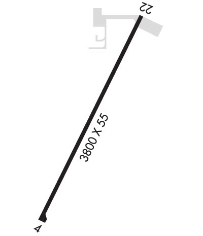
Runway Identifications
Runway Identification: 04/22Length: 3800 ft
Width: 55 ft
Surface: ASPHALT-GOOD CONDITION
Edge lights: Non-Standard Lighting SystemTreatment: NONE
| | Runway: 04 | | Runway: 22 |
| Mag heading: | 35° | Mag heading: | 215° |
| Rwy Slope: | .00% | Rwy Slope: | .00% |
| Approach: | | Approach: | |
| Pattern: | Left Traffic | Pattern: | Left Traffic |
| Markings: | NONSTANDARD | Markings: | NONSTANDARD |
| Marking Condition: | GOOD; RWY NR DSPLCD FM THR. | Marking Condition: | GOOD; RWY NR DSPLCD FM THR. |
| Arresting Dev: | | Arresting Dev: | |
| Lat & Long: | N4117.3 W08222.5 | Lat. & Long.: | N4117.9 W08222.1 |
| Elev: | 848.0 ft. MSL | Elev: | 848.0 ft. MSL |
| TCH: | | TCH: | |
| Visual Glide Path: | | Visual Glide Path: | |
| Displaced Threshold: | No | Displaced Threshold: | No |
| Touchdown Zone: | NO | Touchdown Zone: | NO |
| Touchdown Elev.: | | Touchdown Elev.: | |
| Visual Glide Slope: | | Visual Glide Slope: | |
| RVR Equipment: | | RVR Equipment: | |
| RVV Equipment: | NO | RVV Equipment: | NO |
| Approach Lights: | | Approach Lights: | |
| REIL: | NO | REIL: | NO |
| Centerline Lights: | NO | Centerline Lights: | NO |
| Touchdown lights: | NO | Touchdown lights: | NO |
| Runway Category: | Runway with a Visual Approach | Runway Category: | Runway with a Visual Approach |
| Declared Distances: | | Declared Distances: | |
| Obstructions: | TREES | Obstructions: | TREES |
| Marked: | NOT Marked/Lighted | Marked: | NOT Marked/Lighted |
| Clearance slope: | 5:1 | Clearance slope: | 17:1 |
| Obstruction height: | 90 feet AGL | Obstruction height: | 100 feet AGL |
| Dist. from runway: | 700 feet | Dist. from runway: | 1995 feet |
| Centerline offset: | 130 right of centerline | Centerline offset: | 22 feet right of centerline |
| Comments: | 8 FT CROPS, 100 FT FM THR, 70 FT L & R OF CNTRLN, CLNC SLOPE 0:1. | Comments: | 8 FT CROPS, 30 FT FM THR, 125 FT L & R OF CNTRLN, CLNC SLOPE 0:1. |

