Approach Charts
| FltPlan does not have IFR approach charts available for KI50. |
Current Weather/Notams (Metars, TAFs, Notams, NWS Forecast, PIREPS, and nearby weather)
Customs Information Send updates to Support@FltPlan.com
Customs Not Available
Database effective 05/16/2024
Airport Diagram might not be current.
|
| Facility Name: | STANTON |
| City Name: | STANTON |
| County: | POWELL |
| State abbrev: | KY |
| State Name: | KENTUCKY |
| | |
| Ownership: | PUBLICLY OWNED |
| Use: | OPEN TO THE PUBLIC |
| Owner's Name: | POWELL CO ARPT BOARD |
| Address: | 310 AIRPORT ROAD |
| | STANTON, KY 40380 |
| Owner's Phone: | 606-599-7997 |
| | |
| Manager's Name: | CHARLES DONALDSON |
| Address: | 310 AIRPORT ROAD |
| | STANTON, KY 40380 |
| Phone: | 606-569-9011 |
| | |
| FAA Region: | SOUTHERN |
| FAA Field Office: | MEM |
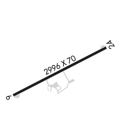
Runway Identifications
Runway Identification: 06/24Length: 2996 ft
Width: 70 ft
Surface: ASPHALT-GOOD CONDITION
Edge lights: Medium IntensityTreatment: NONE
| | Runway: 06 | | Runway: 24 |
| Mag heading: | N/A | Mag heading: | N/A |
| Rwy Slope: | .13% Up | Rwy Slope: | -.13% Down |
| Approach: | | Approach: | |
| Pattern: | Left Traffic | Pattern: | Left Traffic |
| Markings: | BASIC | Markings: | BASIC |
| Marking Condition: | GOOD | Marking Condition: | GOOD |
| Arresting Dev: | | Arresting Dev: | |
| Lat & Long: | N3750.9 W08351.0 | Lat. & Long.: | N3751.1 W08350.5 |
| Elev: | 647.3 ft. MSL | Elev: | 651.1 ft. MSL |
| TCH: | 25 ft. AGL | TCH: | |
| Visual Glide Path: | 3.50 degrees | Visual Glide Path: | |
| Displaced Threshold: | 431 feet | Displaced Threshold: | 221 feet |
| Touchdown Zone: | NO | Touchdown Zone: | NO |
| Touchdown Elev.: | | Touchdown Elev.: | |
| Visual Glide Slope: | 2-Light PAPI on LEFT side of Runway | Visual Glide Slope: | |
| RVR Equipment: | | RVR Equipment: | |
| RVV Equipment: | NO | RVV Equipment: | NO |
| Approach Lights: | | Approach Lights: | |
| REIL: | YES | REIL: | YES |
| Centerline Lights: | NO | Centerline Lights: | NO |
| Touchdown lights: | NO | Touchdown lights: | NO |
| Runway Category: | Runway with a Visual Approach | Runway Category: | Runway with a Visual Approach |
| Declared Distances: | TODA:2890' ASDA:2990' LDA:2460' | Declared Distances: | TODA:2770' ASDA:2990' LDA:2550' |
| Obstructions: | TREES | Obstructions: | ROAD |
| Marked: | NOT Marked/Lighted | Marked: | NOT Marked/Lighted |
| Clearance slope: | 3:1; APCH SLOPE 20:1 TO DSPLCD THR. | Clearance slope: | 1:1; TREES 1,193 FT BYD RWY, 179' RT, AND 113' ABOVE RESULTS IN APCH SLOPE OF 12:1 TO DSPLCD THR. |
| Obstruction height: | 22 feet AGL | Obstruction height: | 8 feet AGL |
| Dist. from runway: | 277 feet | Dist. from runway: | 201 feet |
| Centerline offset: | 122 right of centerline | Centerline offset: | |
| Comments: | +4 FT FENCE, TREES AND BRUSH 65 FT FROM RWY END L/R. | Comments: | |

