Click here for more info on on SMS!

KI34

GREENSBURG MUNICIPAL
GREENSBURG
IN
Time Zone: Eastern
Lat: N 3919.6
Long: W 08531.4
Elev: 912
Var: +04
Longest Runway: 3433
CTAF: 122.9

FBO & Flight Services info for KI34

FBOs: Update your Fuel Prices

GREENSBURG MUNIPh: 812-593-1677
-
Freq: 122.9
Service
Jet
100LL
SAF
MoGas
Fuel Avail: PRIST PREMIXED.
Full        Last Update: 04/05/2024 16:15

Self4.995.99    
 Address: 915 S CO RD 200   W GREENSBURG, IN 47240
If you are an FBO, call 1-203-262-1700 to update your info or email: FltPlan.Advertising@garmin.com
Advertise your FBO on FltPlan.com

Runway & Approach Info for KI34
Rwy
Length
Land Dist**
Approach*
  Rwy
Length
Land Dist**
Approach*
18
3433x40  2933'          
 
  
36
  3433x40  3333'          
 
 * only ILS, LOC, LDA, and SDF approaches to a specific runway are shown
** For any Declared Landing Distance Available, please see A/FD or Approach plates
Runway Weight Capability (lbs.) Help
Runway IDSingle WheelDouble WheelDouble Tandem WheelDual Double Wheel
18/36N/AN/AN/AN/A
These numbers are Advisory and are not limits.   The Airport Manager should have more accurate Weight Limits
Approach Charts
Approaches    
Current Weather/Notams
Customs Information Send updates to Support@FltPlan.com
Customs Not Available
Database effective 04/18/2024
Airport Diagram of KI34
Airport Diagram might not be current.

Facility Name: GREENSBURG MUNI
City Name: GREENSBURG
County: DECATUR
State abbrev: IN
State Name: INDIANA
   
Ownership: PUBLICLY OWNED
Use: OPEN TO THE PUBLIC
Owner's Name: GREENSBURG-DECATUR CO BOAC
Address: 915 S. 200 W
 GREENSBURG, IN 47240
Owner's Phone: (812) 662-6224
  
Manager's Name: JERRY SCHEIDLER
Address: 3551 N. OLD US 421
 GREENSBURG, IN 47240
Phone: 812-593-1677
   
FAA Region: GREAT LAKES
FAA Field Office: CHI


Sunrise / Sunset times for GREENSBURG MUNI

DateSunriseSunset
04/15/24 Monday7:0420:21
04/16/24 Tuesday7:0320:22
04/17/24 Wednesday7:0120:22
04/18/24 Thursday7:0020:23
04/19/24 Friday6:5820:24
04/20/24 Saturday6:5720:25
04/21/24 Sunday6:5520:26
04/22/24 Monday6:5420:27
04/23/24 Tuesday6:5320:28
04/24/24 Wednesday6:5120:29
04/25/24 Thursday6:5020:30
04/26/24 Friday6:4920:31
04/27/24 Saturday6:4720:32
04/28/24 Sunday6:4620:33

Airport Facilities

Airport Attendance ScheduleMON-FRI ON CALL; ATTENDANT - AMGR.
Airport Status OPERATIONAL (This Status can change at any time - please check NOTAMS)
Airport Lighting ScheduleACTVT VASI RWY 18 & 36; MIRL RWY 18/36 - CTAF.
Airport Storage AvailableTie Downs
Extra Services AvailableNONE
Wind IndicatorYES - (lighted)
Control TowerNO
CTAF Frequency122.900
Unicom Frequency
Rotating Beacon ColorWG
Segmented CircleNO
Landing FeeNO

Airport Inspection Data

Airport InspectedSTATE - performed by STATE AERONAUTICAL PERSONNEL
Inspection Date02/03/2021

Airport Services

Type of Fuel AvailableGrade 100LL, JET A (freeze point -40C)
Airframe Repair ServiceMINOR
Power Plant Repair ServiceMINOR

Geographic Data

LatitudeN3919.6
LongitudeW08531.4 (ESTIMATED)
Arpt Elevation912ft (SURVEYED)
Magnetic Variation04W
2 miles SWof GREENSBURG
Traffic Pattern Altitude
Sectional ChartST LOUIS

Aircraft Data

Operations (Reported)YearlyAvg. Daily
General Aviation Transient 6302
General Aviation Local 28358
Air Taxi 350
Commerical 00
Commuter 00
Military 00
Aircraft based on Field
General Aviation Singles 29
General Aviation Multi 0
Jet Aircraft 0
General Aviation Helicopters 0
Military Aircraft 0
Gliders 0
Ultralights 0

FAA Services

FSS on field NO
FSS tie-in TERRE HAUTE
FSS Phone 1-800-WX-BRIEF
Who issues Notams HUF
Notam D service at airport YES
ARTCC Name INDIANAPOLIS

Federal Status

Airport Certification
Aircraft Rescue & Firefighting IndexNone
Airport of EntryNo
Custom Landing RightsNo
Joint Civil/MilitaryNo
Military Landing rightsNo

Federal Agreements

NATIONAL PLAN OF INTEGRATED AIRPORT SYSTEMS (NPIAS)

Remarks

THIS AIRPORT HAS BEEN SURVEYED BY THE NATIONAL GEODETIC SURVEY.
FOR CD CTC INDIANAPOLIS APCH AT 317-227-5743.
Airport Communications & Frequencies:
CTAF Frequency:
122.900
Remarks
  • COMMUNICATIONS PRVDD BY TERRE HAUTE RADIO ON FREQ 122.3 (OSGOOD RCO).
  • INDIANAPOLIS Primary Approach Frequencies:  
    127.15
    INDIANAPOLIS Primary Departure Frequencies:  
    127.15
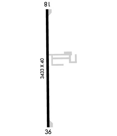
    Runway Identifications
    Runway Identification: 18/36
    Length: 3433 ft
    Width: 40 ft
    Surface: ASPHALT-GOOD CONDITION
    Edge lights: Medium Intensity

    Treatment: NONE

     Runway: 18   Runway: 36
    Mag heading: 184°Mag heading:
    Rwy Slope: -.20% DownRwy Slope: .20% Up
    Approach: Approach:
    Pattern: Left TrafficPattern: Left Traffic
    Markings: BASICMarkings: BASIC
    Marking Condition: FAIRMarking Condition: FAIR
    Arresting Dev: Arresting Dev:
    Lat & Long: N3919.9  W08531.4Lat. & Long.: N3919.3  W08531.3
    Elev: 912.0 ft. MSLElev: 905.0 ft. MSL
    TCH: 23 ft. AGLTCH: 22 ft. AGL
    Visual Glide Path: 3.25 degreesVisual Glide Path: 3.25 degrees
    Displaced Threshold: 500 feetDisplaced Threshold: 100 feet
    Touchdown Zone: YESTouchdown Zone: YES
    Touchdown Elev.: 912.0 feetTouchdown Elev.: 912.0 feet
    Visual Glide Slope: 2-Box VASI on LEFT side of Runway; VASI UNUSBL BYD 2 DEGS LEFT OF CNTRLN.Visual Glide Slope: 2-Box VASI on LEFT side of Runway
    RVR Equipment: RVR Equipment:
    RVV Equipment: NORVV Equipment: NO
    Approach Lights: Approach Lights:
    REIL: NOREIL: NO
    Centerline Lights: NOCenterline Lights: NO
    Touchdown lights: NOTouchdown lights: NO
    Runway Category: Runway with a Visual ApproachRunway Category: Runway with a Non-precision Approach
    Declared Distances: Declared Distances:
    Obstructions: ROADObstructions: TREES
    Marked: NOT Marked/LightedMarked: NOT Marked/Lighted
    Clearance slope: APCH SLOPE 20:1 TO DTHR.Clearance slope: APCH SLOPE 0:1 TO DTHR DUE TO 60 FT TREES 170 FT L.
    Obstruction height: 20 feet AGLObstruction height: 57 feet AGL
    Dist. from runway: 201 feetDist. from runway: 201 feet
    Centerline offset: 130 right of centerlineCenterline offset: 200 feet left of centerline
    Comments: SCATTERED BRUSH 100 FT FM RWY.Comments:
    C:1/P: