Current Weather/Notams (Metars, TAFs, Notams, NWS Forecast, PIREPS, and nearby weather)
Customs Information Send updates to Support@FltPlan.com
Customs Not Available
Database effective 04/18/2024
Airport Diagram might not be current.
|
| Facility Name: | RANDOLPH COUNTY |
| City Name: | WINCHESTER |
| County: | RANDOLPH |
| State abbrev: | IN |
| State Name: | INDIANA |
| | |
| Ownership: | PUBLICLY OWNED |
| Use: | OPEN TO THE PUBLIC |
| Owner's Name: | RANDOLPH CO BOAC |
| Address: | 2937 E STATE RD32 |
| | WINCHESTER, IN 47394 |
| Owner's Phone: | 765-584-3611 |
| | |
| Manager's Name: | ERIC LIVINGSTON |
| Address: | 2937 E STATE RD 32 |
| | WINCHESTER, IN 47394 |
| Phone: | 765-584-3611 |
| | |
| FAA Region: | GREAT LAKES |
| FAA Field Office: | CHI |
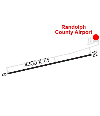
Runway Identifications
Runway Identification: 08/26Length: 4300 ft
Width: 75 ft
Surface: ASPHALT
Edge lights: Medium IntensityTreatment: GROOVED
Weight: PCN 21 /F/A/X/T
| | Runway: 08 | | Runway: 26 |
| Mag heading: | 82° | Mag heading: | 262° |
| Rwy Slope: | .16% Up | Rwy Slope: | -.16% Down |
| Approach: | | Approach: | |
| Pattern: | Left Traffic | Pattern: | Left Traffic |
| Markings: | NONPRECISION INSTRUMENT | Markings: | NONPRECISION INSTRUMENT |
| Marking Condition: | GOOD | Marking Condition: | GOOD |
| Arresting Dev: | | Arresting Dev: | |
| Lat & Long: | N4010.0 W08456.2 | Lat. & Long.: | N4010.1 W08455.3 |
| Elev: | 1115.9 ft. MSL | Elev: | 1122.8 ft. MSL |
| TCH: | 25 ft. AGL | TCH: | 25 ft. AGL |
| Visual Glide Path: | 3.00 degrees | Visual Glide Path: | 3.00 degrees |
| Displaced Threshold: | No | Displaced Threshold: | No |
| Touchdown Zone: | YES | Touchdown Zone: | YES |
| Touchdown Elev.: | 1120.8 feet | Touchdown Elev.: | 1122.8 feet |
| Visual Glide Slope: | 2-Light PAPI on LEFT side of Runway | Visual Glide Slope: | 2-Light PAPI on LEFT side of Runway |
| RVR Equipment: | | RVR Equipment: | |
| RVV Equipment: | NO | RVV Equipment: | NO |
| Approach Lights: | | Approach Lights: | |
| REIL: | YES | REIL: | YES |
| Centerline Lights: | NO | Centerline Lights: | NO |
| Touchdown lights: | NO | Touchdown lights: | NO |
| Runway Category: | Runway with a Non-precision Approach | Runway Category: | Runway with a Non-precision Approach |
| Declared Distances: | | Declared Distances: | |
| Obstructions: | CROPS | Obstructions: | ROAD |
| Marked: | NOT Marked/Lighted | Marked: | NOT Marked/Lighted |
| Clearance slope: | 34:1 | Clearance slope: | 34:1 |
| Obstruction height: | 17 feet AGL | Obstruction height: | 13 feet AGL |
| Dist. from runway: | 780 feet | Dist. from runway: | 650 feet |
| Centerline offset: | 210 right of centerline | Centerline offset: | |
| Comments: | | Comments: | |