
| ||||||||||||||||||||||||||||||||||||||||||||
| ||||||||||||||||||||||||||||||||||||||||||||
| ||||||||||||||||||||||||||||||||||||||||||||
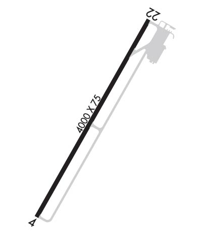
| Rwy | Rwy | |||||||
| 4000x75 | 4000' | 4000x75 | 4000' | |||||
| Runway ID | Single Wheel | Double Wheel | Double Tandem Wheel | Dual Double Wheel |
| 04/22 | 12,500 | N/A | N/A | N/A |
| These numbers are Advisory and are not limits. The Airport Manager should have more accurate Weight Limits | ||||
 Airport Diagram might not be current. | |
| Facility Name: | JACKSON COUNTY |
| City Name: | RAVENSWOOD |
| County: | JACKSON |
| State abbrev: | WV |
| State Name: | WEST VIRGINIA |
| Ownership: | PUBLICLY OWNED |
| Use: | OPEN TO THE PUBLIC |
| Owner's Name: | JACKSON COUNTY CMSN |
| Address: | P. O. BOX 800 |
| RIPLEY, WV 25271 | |
| Owner's Phone: | 304-373-2220 |
| Manager's Name: | RALPH DENNIS |
| Address: | 912 AIRPORT RD |
| MILLWOOD, WV 25262 | |
| Phone: | 304-273-8114; 304-532-6781 MGR CELL. |
| FAA Region: | EASTERN |
| FAA Field Office: | BKW |
| Date | Sunrise | Sunset |
|---|---|---|
| 04/23/24 Tuesday | 6:39 | 20:13 |
| 04/24/24 Wednesday | 6:37 | 20:14 |
| 04/25/24 Thursday | 6:36 | 20:15 |
| 04/26/24 Friday | 6:35 | 20:16 |
| 04/27/24 Saturday | 6:33 | 20:17 |
| 04/28/24 Sunday | 6:32 | 20:18 |
| 04/29/24 Monday | 6:31 | 20:19 |
| 04/30/24 Tuesday | 6:30 | 20:20 |
| 05/01/24 Wednesday | 6:28 | 20:21 |
| 05/02/24 Thursday | 6:27 | 20:22 |
| 05/03/24 Friday | 6:26 | 20:23 |
| 05/04/24 Saturday | 6:25 | 20:24 |
| 05/05/24 Sunday | 6:24 | 20:24 |
| 05/06/24 Monday | 6:23 | 20:25 |
| Airport Attendance Schedule | 7 Days A Week 0800-1600 |
| Airport Status | OPERATIONAL (This Status can change at any time - please check NOTAMS) |
| Airport Lighting Schedule | ACTVT REIL RWY 04 & 22, PAPI RWY 04 & 22; MIRL RWY 04/22 & WINDSOCK LGT - CTAF. |
| Airport Storage Available | Tie Downs, Hanger |
| Extra Services Available | Air Ambulance, Flight Instruction, Aircraft Rental |
| Wind Indicator | YES - (lighted) |
| Control Tower | NO |
| CTAF Frequency | 122.800 |
| Unicom Frequency | 122.800 |
| Rotating Beacon Color | WG |
| Segmented Circle | YES |
| Landing Fee | NO |
| Airport Inspected | STATE - performed by PRIVATE CONTRACT PERSONNEL |
| Inspection Date | 07/06/2022 |
| Type of Fuel Available | Grade 100LL |
| Airframe Repair Service | MAJOR |
| Power Plant Repair Service | MAJOR |
| Latitude | N3855.8 |
| Longitude | W08149.2 (ESTIMATED) |
| Arpt Elevation | 758ft (SURVEYED) |
| Magnetic Variation | 07W |
| 6 miles SW | of RAVENSWOOD |
| Traffic Pattern Altitude | |
| Sectional Chart | CINCINNATI |
| Operations (Reported) | Yearly | Avg. Daily |
|---|---|---|
| General Aviation Transient | 6000 | 16 |
| General Aviation Local | 6000 | 16 |
| Air Taxi | 102 | 0 |
| Commerical | 0 | 0 |
| Commuter | 0 | 0 |
| Military | 300 | 1 |
| Aircraft based on Field | |
|---|---|
| General Aviation Singles | 24 |
| General Aviation Multi | 1 |
| Jet Aircraft | 0 |
| General Aviation Helicopters | 1 |
| Military Aircraft | 0 |
| Gliders | 0 |
| Ultralights | 0 |
| FSS on field | NO |
| FSS tie-in | ELKINS |
| FSS Phone | 1-800-WX-BRIEF |
| Who issues Notams | EKN |
| Notam D service at airport | YES |
| ARTCC Name | INDIANAPOLIS |
| Airport Certification | |
| Aircraft Rescue & Firefighting Index | None |
| Airport of Entry | No |
| Custom Landing Rights | No |
| Joint Civil/Military | No |
| Military Landing rights | YES |
| NATIONAL PLAN OF INTEGRATED AIRPORT SYSTEMS (NPIAS) |
| GRANT AGREEMENTS UNDER FAAP/ADAP/AIP |
| ASSURANCES PURSUANT TO TITLE VI, CIVIL RIGHTS ACT OF 1964 |
| DEER AND BIRDS ON & INVOF ARPT. |
| +482 FT STACK 1/2 MILE NW OF ARPT. |
| RWY SAFETY AREA HAS SFC VARIATIONS. |
| RWY 04/22, 50 FT DROP-OFF 200 FT FM THR - EACH END. |
| 15 FT TREES PARALLEL TO RWY 04, 75 FT L OF CNTRLN. |
| FOR CD CTC HUNTINGTON ATCT AT 304-453-2490. |
Airport Communications & Frequencies:
| ||||||||||||||
| Runway: 04 | Runway: 22 | ||
| Mag heading: | 37° | Mag heading: | 217° |
| Rwy Slope: | .51% Up | Rwy Slope: | -.51% Down |
| Approach: | Approach: | ||
| Pattern: | Left Traffic | Pattern: | Left Traffic |
| Markings: | NONPRECISION INSTRUMENT | Markings: | NONPRECISION INSTRUMENT |
| Marking Condition: | GOOD | Marking Condition: | GOOD |
| Arresting Dev: | Arresting Dev: | ||
| Lat & Long: | N3855.5 W08149.4 | Lat. & Long.: | N3856.1 W08149.0 |
| Elev: | 738.0 ft. MSL | Elev: | 758.2 ft. MSL |
| TCH: | 50 ft. AGL | TCH: | 50 ft. AGL |
| Visual Glide Path: | 3.00 degrees | Visual Glide Path: | 4.00 degrees |
| Displaced Threshold: | No | Displaced Threshold: | No |
| Touchdown Zone: | YES | Touchdown Zone: | YES |
| Touchdown Elev.: | 753.2 feet | Touchdown Elev.: | 758.2 feet |
| Visual Glide Slope: | 2-Light PAPI on LEFT side of Runway | Visual Glide Slope: | 2-Light PAPI on LEFT side of Runway; VGSI AND DESCENT ANGLES NOT COINCIDENT. |
| RVR Equipment: | RVR Equipment: | ||
| RVV Equipment: | NO | RVV Equipment: | NO |
| Approach Lights: | Approach Lights: | ||
| REIL: | YES | REIL: | YES |
| Centerline Lights: | NO | Centerline Lights: | NO |
| Touchdown lights: | NO | Touchdown lights: | NO |
| Runway Category: | Runway with a Non-precision Approach | Runway Category: | Runway with a Non-precision Approach |
| Declared Distances: | Declared Distances: | ||
| Obstructions: | TREES | Obstructions: | TREES |
| Marked: | NOT Marked/Lighted | Marked: | NOT Marked/Lighted |
| Clearance slope: | 20:1 | Clearance slope: | 1:1 |
| Obstruction height: | 61 feet AGL | Obstruction height: | 22 feet AGL |
| Dist. from runway: | 1430 feet | Dist. from runway: | 220 feet |
| Centerline offset: | Centerline offset: | 245 feet left of centerline | |
| Comments: | Comments: | 16 FT TREES, 150-200 DSTC, 170-250 FT L. |
