| ||||||||||||||||||||||||||||||||||||||||||||||||||||||||||||||||||||
| ||||||||||||||||||||||||||||||||||||||||||||||||||||||||||||||||||||
| ||||||||||||||||||||||||||||||||||||||||||||||||||||||||||||||||||||
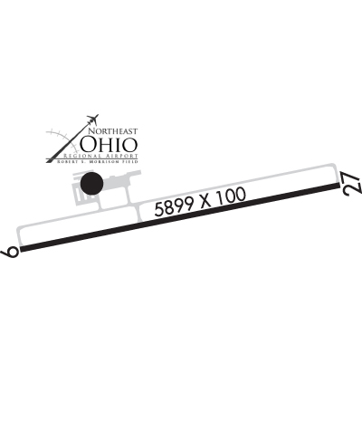
| Rwy | Rwy | |||||||
| 5900x100 | 5900' | 5900x100 | 5500' | |||||
| Runway ID | Single Wheel | Double Wheel | Double Tandem Wheel | Dual Double Wheel |
| 09/27 | 70,000 | 100,000 | 150,000 | N/A |
| These numbers are Advisory and are not limits. The Airport Manager should have more accurate Weight Limits | ||||
 Airport Diagram might not be current. | |
| Facility Name: | NORTHEAST OHIO RGNL |
| City Name: | ASHTABULA |
| County: | ASHTABULA |
| State abbrev: | OH |
| State Name: | OHIO |
| Ownership: | PUBLICLY OWNED |
| Use: | OPEN TO THE PUBLIC |
| Owner's Name: | ASHTABULA CO ARPT AUTH |
| Address: | PO BOX 379 |
| JEFFERSON, OH 44047-0379 | |
| Owner's Phone: | 440-576-9271 |
| Manager's Name: | LANCE BUSHWEILER |
| Address: | PO BOX 379; ARPT PHYS ADS: 2382 AIRPORT RD, JEFFERSON, OH 44047-9491. |
| JEFFERSON, OH 44047-0379 | |
| Phone: | 440-576-9271 |
| FAA Region: | GREAT LAKES |
| FAA Field Office: | DET |
| Date | Sunrise | Sunset |
|---|---|---|
| 04/23/24 Tuesday | 6:29 | 20:13 |
| 04/24/24 Wednesday | 6:28 | 20:14 |
| 04/25/24 Thursday | 6:26 | 20:15 |
| 04/26/24 Friday | 6:25 | 20:17 |
| 04/27/24 Saturday | 6:24 | 20:18 |
| 04/28/24 Sunday | 6:22 | 20:19 |
| 04/29/24 Monday | 6:21 | 20:20 |
| 04/30/24 Tuesday | 6:20 | 20:21 |
| 05/01/24 Wednesday | 6:18 | 20:22 |
| 05/02/24 Thursday | 6:17 | 20:23 |
| 05/03/24 Friday | 6:16 | 20:24 |
| 05/04/24 Saturday | 6:14 | 20:25 |
| 05/05/24 Sunday | 6:13 | 20:26 |
| 05/06/24 Monday | 6:12 | 20:27 |
| Airport Attendance Schedule | MON-FRI 0800-1700, SAT-SUN ON CALL; UNATNDD CHRISTMAS & NEW YEARS DAY. |
| Airport Status | OPERATIONAL (This Status can change at any time - please check NOTAMS) |
| Airport Lighting Schedule | ACTVT REIL RWY 09 & 27; HIRL RWY 09/27 - 123.3. PAPI RWY 09 & 27 OPR CONSLY. |
| Airport Storage Available | Tie Downs, Hanger |
| Extra Services Available | Flight Instruction, Aircraft Rental |
| Wind Indicator | YES - (lighted) |
| Control Tower | NO |
| CTAF Frequency | 122.800 |
| Unicom Frequency | 122.800 |
| Rotating Beacon Color | WG |
| Segmented Circle | YES |
| Landing Fee | NO; RAMP FEE FOR TURBINE ACFT. |
| Airport Inspected | STATE - performed by STATE AERONAUTICAL PERSONNEL |
| Inspection Date | 10/12/2021 |
| Type of Fuel Available | Grade 100LL, JET A; -10100LL AVBL H24 SELF SVC VIA CREDIT CARD. |
| Airframe Repair Service | NONE |
| Power Plant Repair Service | NONE |
| Latitude | N4146.7 |
| Longitude | W08041.8 (ESTIMATED) |
| Arpt Elevation | 926ft (SURVEYED) |
| Magnetic Variation | 09W |
| 8 miles SE | of ASHTABULA |
| Traffic Pattern Altitude | |
| Sectional Chart | DETROIT |
| Operations (Reported) | Yearly | Avg. Daily |
|---|---|---|
| General Aviation Transient | 520 | 1 |
| General Aviation Local | 528 | 1 |
| Air Taxi | 145 | 0 |
| Commerical | 0 | 0 |
| Commuter | 0 | 0 |
| Military | 2 | 0 |
| Aircraft based on Field | |
|---|---|
| General Aviation Singles | 21 |
| General Aviation Multi | 1 |
| Jet Aircraft | 2 |
| General Aviation Helicopters | 0 |
| Military Aircraft | 0 |
| Gliders | 0 |
| Ultralights | 0 |
| FSS on field | NO |
| FSS tie-in | CLEVELAND |
| FSS Phone | 1-800-WX-BRIEF |
| Who issues Notams | HZY |
| Notam D service at airport | YES |
| ARTCC Name | CLEVELAND |
| Airport Certification | |
| Aircraft Rescue & Firefighting Index | None |
| Airport of Entry | No |
| Custom Landing Rights | No |
| Joint Civil/Military | No |
| Military Landing rights | YES |
| NATIONAL PLAN OF INTEGRATED AIRPORT SYSTEMS (NPIAS) |
| GRANT AGREEMENTS UNDER FAAP/ADAP/AIP |
| ASSURANCES PURSUANT TO TITLE VI, CIVIL RIGHTS ACT OF 1964 |
| THIS AIRPORT HAS BEEN SURVEYED BY THE NATIONAL GEODETIC SURVEY. |
| SNOW REMOVAL OPS DRG ATNDD HRS, MAY BE LTD HOLS & WKENDS. |
| SER: ACFT DEICE - TYPE 1 & 4 FLUID, LAV CART, & GPU AVBL. |
| FOR CD CTC BUFFALO APCH AT 716-626-6920, WHEN APCH CLSD CTC CLEVELAND ARTCC AT 440-774-0232. |
| FLD CONDS UNMON AFT BUS HRS. |
| DEER & BIRDS INVOF ARPT. |
Airport Communications & Frequencies:
| |||||||||||||
| Runway: 09 | Runway: 27 | ||
| Mag heading: | 88° | Mag heading: | 268° |
| Rwy Slope: | .33% Up | Rwy Slope: | -.33% Down |
| Approach: | Approach: | ||
| Pattern: | Left Traffic | Pattern: | Left Traffic |
| Markings: | NONPRECISION INSTRUMENT | Markings: | NONPRECISION INSTRUMENT |
| Marking Condition: | FAIR | Marking Condition: | FAIR |
| Arresting Dev: | Arresting Dev: | ||
| Lat & Long: | N4146.6 W08042.4 | Lat. & Long.: | N4146.8 W08041.2 |
| Elev: | 906.8 ft. MSL | Elev: | 926.0 ft. MSL |
| TCH: | 45 ft. AGL | TCH: | 45 ft. AGL |
| Visual Glide Path: | 3.00 degrees | Visual Glide Path: | 3.00 degrees |
| Displaced Threshold: | No | Displaced Threshold: | 400 feet |
| Touchdown Zone: | YES | Touchdown Zone: | YES |
| Touchdown Elev.: | 916.3 feet | Touchdown Elev.: | 924.9 feet |
| Visual Glide Slope: | 4-Light PAPI on LEFT side of Runway | Visual Glide Slope: | 4-Light PAPI on LEFT side of Runway |
| RVR Equipment: | RVR Equipment: | ||
| RVV Equipment: | NO | RVV Equipment: | NO |
| Approach Lights: | Approach Lights: | ||
| REIL: | YES | REIL: | YES |
| Centerline Lights: | NO | Centerline Lights: | NO |
| Touchdown lights: | NO | Touchdown lights: | NO |
| Runway Category: | Runway with a Non-precision Approach having visibility minimums greater than 3/4 mile | Runway Category: | Runway with a Non-precision Approach having visibility minimums greater than 3/4 mile |
| Declared Distances: | TORA:5900' TODA:5900' ASDA:5100' LDA:5100' | Declared Distances: | TORA:5900' TODA:5900' ASDA:5500' LDA:5100' |