Current Weather/Notams (Metars, TAFs, Notams, NWS Forecast, PIREPS, and nearby weather)
Customs Information Send updates to Support@FltPlan.com
Customs Not Available
Database effective 05/16/2024
Airport Diagram might not be current.
|
| Facility Name: | SAGINAW COUNTY/H W BROWNE |
| City Name: | SAGINAW |
| County: | SAGINAW |
| State abbrev: | MI |
| State Name: | MICHIGAN |
| | |
| Ownership: | PUBLICLY OWNED |
| Use: | OPEN TO THE PUBLIC |
| Owner's Name: | COUNTY OF SAGINAW |
| Address: | 4821 JANES RD |
| | SAGINAW, MI 48601-9656 |
| Owner's Phone: | 989-758-2459 |
| | |
| Manager's Name: | ALAN KAUFMAN |
| Address: | 4789 JANES RD |
| | SAGINAW, MI 48601 |
| Phone: | 989-295-0675 |
| | |
| FAA Region: | GREAT LAKES |
| FAA Field Office: | DET |
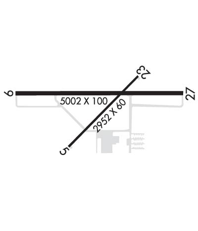
Runway Identifications
Runway Identification: 05/23Length: 2952 ft
Width: 60 ft
Surface: ASPHALT-FAIR CONDITION
Edge lights: Medium IntensityTreatment: NONE
| | Runway: 05 | | Runway: 23 |
| Mag heading: | 52° | Mag heading: | 232° |
| Rwy Slope: | -.10% Down | Rwy Slope: | .10% Up |
| Approach: | | Approach: | |
| Pattern: | Left Traffic | Pattern: | Left Traffic |
| Markings: | BASIC | Markings: | BASIC |
| Marking Condition: | GOOD | Marking Condition: | GOOD |
| Arresting Dev: | | Arresting Dev: | |
| Lat & Long: | N4325.8 W08352.0 | Lat. & Long.: | N4326.1 W08351.5 |
| Elev: | 600.8 ft. MSL | Elev: | 597.9 ft. MSL |
| TCH: | 25 ft. AGL | TCH: | 25 ft. AGL |
| Visual Glide Path: | 3.00 degrees | Visual Glide Path: | 3.00 degrees |
| Displaced Threshold: | 119 feet | Displaced Threshold: | 129 feet |
| Touchdown Zone: | YES | Touchdown Zone: | YES |
| Touchdown Elev.: | 601.5 feet | Touchdown Elev.: | 601.5 feet |
| Visual Glide Slope: | 2-Light PAPI on LEFT side of Runway | Visual Glide Slope: | 2-Light PAPI on RIGHT side of Runway |
| RVR Equipment: | | RVR Equipment: | |
| RVV Equipment: | NO | RVV Equipment: | NO |
| Approach Lights: | | Approach Lights: | |
| REIL: | NO | REIL: | NO |
| Centerline Lights: | NO | Centerline Lights: | NO |
| Touchdown lights: | NO | Touchdown lights: | NO |
| Runway Category: | Runway with a Visual Approach | Runway Category: | Runway with a Visual Approach |
| Declared Distances: | | Declared Distances: | |
| Obstructions: | FENCE | Obstructions: | ROAD |
| Marked: | NOT Marked/Lighted | Marked: | NOT Marked/Lighted |
| Clearance slope: | 1:1; APCH RATIO 22:1 TO DTHR OVR 15 FT ROAD, 330 FT DIST, 158 FT R. | Clearance slope: | 1:1; APCH RATIO 22:1 TO DTHR OVR 15 FT ROAD, 330 FT DIST, 158 FT R. |
| Obstruction height: | 6 feet AGL | Obstruction height: | 15 feet AGL |
| Dist. from runway: | 200 feet | Dist. from runway: | 210 feet |
| Centerline offset: | 120 right of centerline | Centerline offset: | 126 feet right of centerline |
| Comments: | | Comments: | 2 FT CONC CULVERT, 100 FT DIST, 80 FT L; -15 FT DITCH, ACRS APCH END. |
Runway Identification: 10/28Length: 5002 ft
Width: 100 ft
Surface: ASPHALT
Edge lights: High IntensityTreatment: NONE
| | Runway: 10 | | Runway: 28 |
| Mag heading: | 97° | Mag heading: | 277° |
| Rwy Slope: | -.03% Down | Rwy Slope: | .03% Up |
| Approach: | | Approach: | ILS/DME |
| Pattern: | Left Traffic | Pattern: | Left Traffic |
| Markings: | NONPRECISION INSTRUMENT | Markings: | PRECISION INSTRUMENT |
| Marking Condition: | GOOD | Marking Condition: | GOOD |
| Arresting Dev: | | Arresting Dev: | |
| Lat & Long: | N4326.0 W08352.3 | Lat. & Long.: | N4326.0 W08351.2 |
| Elev: | 598.7 ft. MSL | Elev: | 597.3 ft. MSL |
| TCH: | 45 ft. AGL | TCH: | 44 ft. AGL |
| Visual Glide Path: | 3.00 degrees | Visual Glide Path: | 3.00 degrees |
| Displaced Threshold: | No | Displaced Threshold: | No |
| Touchdown Zone: | YES | Touchdown Zone: | YES |
| Touchdown Elev.: | 599.7 feet | Touchdown Elev.: | 599.3 feet |
| Visual Glide Slope: | 4-Light PAPI on LEFT side of Runway | Visual Glide Slope: | 4-Light PAPI on LEFT side of Runway |
| RVR Equipment: | | RVR Equipment: | |
| RVV Equipment: | NO | RVV Equipment: | NO |
| Approach Lights: | | Approach Lights: | MALSF - 1,400 foot medium intensity approach lighting system with sequenced flashers |
| REIL: | YES | REIL: | NO |
| Centerline Lights: | NO | Centerline Lights: | NO |
| Touchdown lights: | NO | Touchdown lights: | NO |
| Runway Category: | D | Runway Category: | Precision Instrument Runway |
| Declared Distances: | | Declared Distances: | |
| Obstructions: | TREE | Obstructions: | TREES |
| Marked: | NOT Marked/Lighted | Marked: | NOT Marked/Lighted |
| Clearance slope: | 22:1 | Clearance slope: | 9:1 |
| Obstruction height: | 83 feet AGL | Obstruction height: | 45 feet AGL |
| Dist. from runway: | 2060 feet | Dist. from runway: | 629 feet |
| Centerline offset: | 740 left of centerline | Centerline offset: | 300 feet left of centerline |
| Comments: | | Comments: | |

