KHYA

BARNSTABLE BOARDMAN POLANDO
HYANNIS
MA
Time Zone: Eastern
Lat: N 4140.2
Long: W 07016.8
Elev: 54
Var: +16
Longest Runway: 5425
Clr Del: 125.15
Dept. ATIS: 123.8
Arr. ATIS: 123.8
Ground: 118.45
Tower: 119.5

FBO & Flight Services info for KHYA

FBOs: Update your Fuel Prices

  click here  
Providing high quality fuel and services to you and your customers, from Phillips 66 Aviation.
Ph: 508-778-7770 Fax: 508-775-4854 Freq: 122.95WebsiteE-Mail
                          
Service
Jet
100LL
SAF
MoGas
Fuel Avail: 24 hrs - Fuel System Ice Inhibitor PreBlended (Phillips66)
Full6.17      Last Update: 04/23/2024 10:57

Normally effective Wednesdays @ 0001hrs
Self        
Misc. Info: Call on 122.950 mHz | East Ramp | Pilot Lounge | GPU | NO CALLOUT FEES!Address: 125 MARY DUNN WAY, GATE A   HYANNIS, MA 02601
Atlantic Aviation is your premier aviation service provider with more than 100 locations in North America, including Hawaii and the Caribbean. We provide standard ground services you'd expect, with a detailed focus on ensuring an unforgettable customer experience.
Ph: 508-771-7520
-
Freq: 128.82WebsiteE-Mail
                                   
Service
Jet
100LL
SAF
MoGas
Fuel Avail: FBO Hours: Mon-Sun: 0600-1800
Full  7.25    Last Update: 04/21/2024 10:20

Self        
Misc. Info: Address: 730 BARNSTABLE RD   HYANNIS, MA 02601

GRIFFIN AVPh: 508-771-2865 Fax: 508-778-1102 Freq: 122.85
Service
Jet
100LL
SAF
MoGas
Fuel Avail: 0800-1900 Sunday-Saturday
Full  7.08    Last Update: 04/21/2024 10:20  
Self        
 Address: 630 BARNSTABLE RD   HYANNIS, MA 02601
ATISPh: 508-778-1143
-
-
 
ASOSPh: 508-862-2601
-
-
 
If you are an FBO, call 1-203-262-1700 to update your info or email: FltPlan.Advertising@garmin.com
Advertise your FBO on FltPlan.com

Runway & Approach Info for KHYA
Rwy
Length
Land Dist**
Approach*
  Rwy
Length
Land Dist**
Approach*
06
5425x150  5019'          
 
  
24
  5425x150  5425'          
ILS/DME
 109.15 - 246°  
15
5255x150  5255'          
ILS/DME
 108.95 - 156°  
  
33
  5255x150  5105'          
 
 * only ILS, LOC, LDA, and SDF approaches to a specific runway are shown
** For any Declared Landing Distance Available, please see A/FD or Approach plates
Runway Weight Capability (lbs.) Help
Runway IDSingle WheelDouble WheelDouble Tandem WheelDual Double Wheel
06/2430,000108,000N/AN/A
15/3330,000108,000N/AN/A
These numbers are Advisory and are not limits.   The Airport Manager should have more accurate Weight Limits
Approach Charts
Approaches    
Current Weather/Notams
Customs Information Send updates to Support@FltPlan.com
Phone 508-994-5158
Fax 508-979-1285

Comments Avaliable 24/7. *48 hours advanced notice* After service hours fee applies. Landing rights airport. Private airport. Must be US or Canadian Citizen or Greencard holder.
Database effective 05/16/2024
Airport Diagram of KHYA
Airport Diagram might not be current.

Facility Name: CAPE COD GATEWAY
City Name: HYANNIS
County: BARNSTABLE
State abbrev: MA
State Name: MASSACHUSETTS
   
Ownership: PUBLICLY OWNED
Use: OPEN TO THE PUBLIC
Owner's Name: TOWN OF BARNSTABLE
Address: TOWN HALL 367 MAIN ST
 HYANNIS, MA 02601
Owner's Phone: 508-862-4600
  
Manager's Name: KATIE RILEY SERVIS
Address: 480 BARNSTABLE RD
 HYANNIS, MA 02601
Phone: 508-775-2020
   
FAA Region: NEW ENGLAND
FAA Field Office: NONE


Sunrise / Sunset times for CAPE COD GATEWAY

DateSunriseSunset
04/22/24 Monday5:4919:30
04/23/24 Tuesday5:4819:31
04/24/24 Wednesday5:4619:32
04/25/24 Thursday5:4519:34
04/26/24 Friday5:4419:35
04/27/24 Saturday5:4219:36
04/28/24 Sunday5:4119:37
04/29/24 Monday5:3919:38
04/30/24 Tuesday5:3819:39
05/01/24 Wednesday5:3719:40
05/02/24 Thursday5:3619:41
05/03/24 Friday5:3419:42
05/04/24 Saturday5:3319:43
05/05/24 Sunday5:3219:44

Airport Facilities

Airport Attendance ScheduleCONTINUOUS; AVGAS UNAVBL BTN 1900 & 0600 LCL DLY. CALL GRIFFIN AFT HRS 508-367-2140.
Airport Status OPERATIONAL (This Status can change at any time - please check NOTAMS)
Airport Lighting ScheduleACTVT MALSR RWY 15; MALSF RWY 24; HIRL RWYS 06/24 & 15/33 - CTAF.
Airport Storage AvailableTie Downs, Hanger
Extra Services AvailableAir Freight, Avionics, Charter, Flight Instruction, Aircraft Rental, Aircraft Sales
Wind IndicatorYES - (lighted)
Control TowerYES
CTAF Frequency119.500
Unicom Frequency122.950
Rotating Beacon ColorWG
Segmented CircleYES
Landing FeeNO; LDG FEE FOR ALL ACFT OVER 6000 LBS.

Airport Inspection Data

Airport InspectedFEDERAL - performed by FAA AIRPORTS FIELD PERSONNEL
Inspection Date04/13/2023

Airport Services

Type of Fuel AvailableGrade 100LL, JET A (freeze point -40C)
Airframe Repair ServiceMAJOR
Power Plant Repair ServiceMAJOR

Geographic Data

LatitudeN4140.2
LongitudeW07016.8 (ESTIMATED)
Arpt Elevation54ft (SURVEYED)
Magnetic Variation16W
1 miles Nof HYANNIS
Traffic Pattern Altitude
Sectional ChartNEW YORK

Aircraft Data

Operations (Reported)YearlyAvg. Daily
General Aviation Transient 1943653
General Aviation Local 1017228
Air Taxi 2296463
Commerical 2401
Commuter 00
Military 4951
Aircraft based on Field
General Aviation Singles 28
General Aviation Multi 7
Jet Aircraft 0
General Aviation Helicopters 2
Military Aircraft 0
Gliders 1
Ultralights 0

FAA Services

FSS on field NO
FSS tie-in BRIDGEPORT
FSS Phone 1-800-WX-BRIEF
Who issues Notams HYA
Notam D service at airport YES
ARTCC Name BOSTON

Federal Status

Airport CertificationAIRPORT RECEIVING SCHEDULED AIR CARRIER SERVICE FROM CARRIERS CERTIFICATED BY THE CIVIL AERONAUTICS BOARD; CLSD TO UNSKED ACR OPS WITH MORE THAN 9 PAX SEATS 0000-0600 EXCP 1 HR PPR AMGR 508-778-7770.
Aircraft Rescue & Firefighting IndexAIRPORT HAS A CERTIFICATE UNDER CFR PART 139
Airport of EntryNo
Custom Landing RightsYES
Joint Civil/MilitaryNo
Military Landing rightsYES

Federal Agreements

NATIONAL PLAN OF INTEGRATED AIRPORT SYSTEMS (NPIAS)
GRANT AGREEMENTS UNDER FAAP/ADAP/AIP
SURPLUS PROPERTY AGREEMENT UNDER PUBLIC LAW 289
ASSURANCES PURSUANT TO TITLE VI, CIVIL RIGHTS ACT OF 1964
AGREEMENT UNDER DLAND OR DCLA HAS EXPIRED.

Remarks

ANT ON TANK 4600 FT SE ELEV 208 FT; STANDPIPE 7050 FT NORTH 236 FT; OBSTN LGTD.
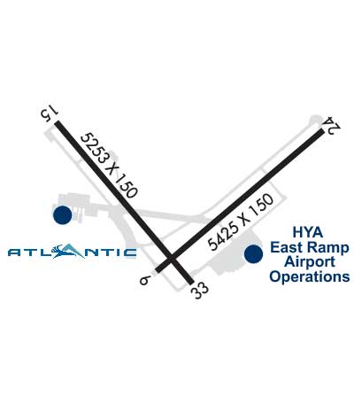
TWY B CLSD TO ACFT WITH WINGSPAN GTR THAN 118 FT. TWY B BTN TWY D & RWY 6-24 CLSD TO ACFT WITH WINGSPAN GTR THAN 78 FT.
INDEX B ARFF EQUIP AVBL DURG ALL SKED ACR OPS.
BE AWARE OF HIGH-SPD MIL JET & HVY HEL TFC VCNTY JOINT BASE CAPE COD. DO NOT CONFUSE JOINT BASE CAPE COD, 10NM W WITH CAPE COD GATEWAY.
BIRDS, COYOTES ON & INVOF ARPT.
ARPT HAS NOISE ABATEMENT CTC AMGR 508-778-7765.
TGL OPS PROHIBITED BTN 2100-0559, PPR BY AMGR.
ALL TSNT & GA PILOTS MUST CTC ARPT OPS ON FREQ 122.95 PRIOR TO ENG SHTDN FOR AIRFIELD ESCORT BTN 2200-0559 LCL.
Airport Communications & Frequencies:
ATIS Frequencies:   Hours(local) of Operation: CONTINUOUS
123.8
HYANNIS Tower Frequencies:   Hours(local) of operation: 0600-2200   
119.5
257.8
HYANNIS Ground Frequencies:
118.45
Clearance Delivery Frequencies:
125.15
120.125 WHEN TWR CLSD
CTAF Frequency:
119.500
Unicom Frequency:
122.950
Remarks
  • APCH/DEP SVC PRVDD BY BOSTON ARTCC ON FREQS 128.75/290.3 (BARNSTABLE RCAG) 0000-0500.
  • BOSTON Primary Approach Frequencies:  
    118.2
    284.6
    BOSTON Primary Departure Frequencies:  
    118.2
    284.6
    Runway Identifications
    Runway Identification: 06/24
    Length: 5425 ft
    Width: 150 ft
    Surface: ASPHALT-GOOD CONDITION
    Edge lights: High Intensity

    Treatment: GROOVED
    Weight: PCN 32 /F/A/X/T

     Runway: 06   Runway: 24
    Mag heading: 66°Mag heading: 246°
    Rwy Slope: -.10% DownRwy Slope: .10% Up
    Approach: Approach: ILS/DME
    Pattern: Left TrafficPattern: Left Traffic
    Markings: PRECISION INSTRUMENTMarkings: PRECISION INSTRUMENT
    Marking Condition: GOODMarking Condition: GOOD
    Arresting Dev: Arresting Dev: EMAS; ENGINEERING MTRLS ARST SYS (EMAS) 200 FT IN LEN BY 176 FT WID LCTD AT THE DER 24.
    Lat & Long: N4139.9  W07017.0Lat. & Long.: N4140.5  W07016.1
    Elev: 44.4 ft. MSLElev: 39.1 ft. MSL
    TCH: 37 ft. AGLTCH: 50 ft. AGL
    Visual Glide Path: 3.00 degreesVisual Glide Path: 3.00 degrees
    Displaced Threshold: 406 feetDisplaced Threshold: No
    Touchdown Zone: YESTouchdown Zone: YES
    Touchdown Elev.: 44.7 feetTouchdown Elev.: 43.1 feet
    Visual Glide Slope: 4-Light PAPI on LEFT side of RunwayVisual Glide Slope: 4-Light PAPI on LEFT side of Runway
    RVR Equipment: ROLLOUTRVR Equipment: TOUCHDOWN
    RVV Equipment: NORVV Equipment: YES
    Approach Lights: Approach Lights: MALSF - 1,400 foot medium intensity approach lighting system with sequenced flashers
    REIL: YESREIL: NO
    Centerline Lights: NOCenterline Lights: NO
    Touchdown lights: NOTouchdown lights: NO
    Runway Category: Runway with a Non-precision Approach having visibility minimums greater than 3/4 mileRunway Category: Precision Instrument Runway
    Declared Distances: TORA:5425' TODA:5425' ASDA:5425' LDA:5019'Declared Distances: TORA:5425' TODA:5425' ASDA:5425' LDA:5425'
    Obstructions: TREEObstructions: RR
    Marked: NOT Marked/LightedMarked: NOT Marked/Lighted
    Clearance slope: 14:1; APCH RATIO 50:1 TO DTHR.Clearance slope: 10:1
    Obstruction height: 17 feet AGLObstruction height: 20 feet AGL
    Dist. from runway: 450 feetDist. from runway: 400 feet
    Centerline offset: 300 left of centerlineCenterline offset: 300 feet left of centerline
    Comments: Comments:
    Runway Identification: 15/33
    Length: 5255 ft
    Width: 150 ft
    Surface: ASPHALT-GOOD CONDITION
    Edge lights: High Intensity

    Treatment: GROOVED
    Weight: PCN 43 /F/A/X/T

     Runway: 15   Runway: 33
    Mag heading: 156°Mag heading: 336°
    Rwy Slope: -.22% DownRwy Slope: .22% Up
    Approach: ILS/DMEApproach:
    Pattern: Left TrafficPattern: Left Traffic
    Markings: PRECISION INSTRUMENTMarkings: PRECISION INSTRUMENT
    Marking Condition: GOODMarking Condition: GOOD
    Arresting Dev: Arresting Dev:
    Lat & Long: N4140.5  W07017.5Lat. & Long.: N4139.8  W07016.8
    Elev: 54.1 ft. MSLElev: 42.4 ft. MSL
    TCH: TCH: 53 ft. AGL
    Visual Glide Path: Visual Glide Path: 3.00 degrees
    Displaced Threshold: NoDisplaced Threshold: 150 feet; APCH RATIO 34:1 TO DTHR.
    Touchdown Zone: YESTouchdown Zone: YES
    Touchdown Elev.: 54.1 feetTouchdown Elev.: 50.0 feet
    Visual Glide Slope: Visual Glide Slope: 4-Light PAPI on LEFT side of Runway
    RVR Equipment: TOUCHDOWNRVR Equipment: ROLLOUT
    RVV Equipment: NORVV Equipment: NO
    Approach Lights: MALSR - 1,400 foot medium intensity approach lighting system with runway alignment indicator lightsApproach Lights:
    REIL: NOREIL: NO
    Centerline Lights: NOCenterline Lights: NO
    Touchdown lights: NOTouchdown lights: NO
    Runway Category: Precision Instrument RunwayRunway Category: Runway with a Non-precision Approach having visibility minimums greater than 3/4 mile
    Declared Distances: TORA:5255' TODA:5255' ASDA:5255' LDA:5255'Declared Distances: TORA:5255' TODA:5255' ASDA:5255' LDA:5105'
    Obstructions: PLINEObstructions:
    Marked: LIGHTEDMarked:
    Clearance slope: 34:1Clearance slope: 34:1; APCH RATIO 34:1 TO DTHR.
    Obstruction height: 146 feet AGLObstruction height:
    Dist. from runway: 5175 feetDist. from runway:
    Centerline offset: Centerline offset:
    Comments: Comments:
    C:77/P: