Current Weather/Notams (Metars, TAFs, Notams, NWS Forecast, PIREPS, and nearby weather)
Customs Information Send updates to Support@FltPlan.com
Customs Not Available
Database effective 04/18/2024
Airport Diagram might not be current. Facility Name: HAYWARD EXEC City Name: HAYWARD County: ALAMEDA State abbrev: CA State Name: CALIFORNIA Ownership: PUBLICLY OWNED Use: OPEN TO THE PUBLIC Owner's Name: CITY OF HAYWARD; CITY MANAGER Address: 777 B ST HAYWARD, CA 94541 Owner's Phone: 510-583-4310 Manager's Name: DOUG MCNEELEY Address: 20301 SKYWEST DR HAYWARD, CA 94541-4699 Phone: (510) 293-8678 FAA Region: WESTERN-PACIFIC FAA Field Office: SFO
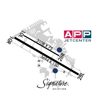
Runway Identifications Help
Runway Identification: 10L/28R Length: 3108 ftWidth: 75 ftSurface: ASPHALT-GOOD CONDITIONEdge lights: Medium Intensity Treatment: NONE Runway: 10L Runway: 28R Mag heading: 105° Mag heading: 285° Rwy Slope: .29% Up Rwy Slope: -.29% Down Approach: Approach: Pattern: Left Traffic Pattern: Right Traffic Markings: NONPRECISION INSTRUMENT Markings: NONPRECISION INSTRUMENT Marking Condition: GOOD Marking Condition: GOOD Arresting Dev: Arresting Dev: Lat & Long: N3739.7 W12207.6 Lat. & Long.: N3739.5 W12207.1 Elev: 28.1 ft. MSL Elev: 37.1 ft. MSL TCH: 29 ft. AGL TCH: 44 ft. AGL Visual Glide Path: 3.00 degrees Visual Glide Path: 3.00 degrees Displaced Threshold: No Displaced Threshold: No Touchdown Zone: YES Touchdown Zone: YES Touchdown Elev.: 36.9 feet Touchdown Elev.: 37.2 feet Visual Glide Slope: 4-Light PAPI on LEFT side of Runway Visual Glide Slope: 4-Light PAPI on LEFT side of Runway RVR Equipment: RVR Equipment: RVV Equipment: NO RVV Equipment: NO Approach Lights: Approach Lights: REIL: NO REIL: NO Centerline Lights: NO Centerline Lights: NO Touchdown lights: NO Touchdown lights: NO Runway Category: Runway with a Visual Approach Runway Category: Runway with a Visual Approach Declared Distances: Declared Distances: Obstructions: TREE Obstructions: Marked: NOT Marked/Lighted Marked: Clearance slope: 14:1 Clearance slope: 50:1 Obstruction height: 60 feet AGL Obstruction height: Dist. from runway: 1085 feet Dist. from runway: Centerline offset: 143 left of centerline Centerline offset: Comments: Comments:
Runway Identification: 10R/28L Length: 5694 ftWidth: 150 ftSurface: ASPHALTEdge lights: Medium Intensity Treatment: GROOVED Runway: 10R Runway: 28L Mag heading: 105° Mag heading: 285° Rwy Slope: .43% Up Rwy Slope: -.43% Down Approach: Approach: LOC/DME Pattern: Right Traffic Pattern: Left Traffic Markings: PRECISION INSTRUMENT Markings: PRECISION INSTRUMENT Marking Condition: GOOD Marking Condition: GOOD Arresting Dev: Arresting Dev: Lat & Long: N3739.7 W12207.8 Lat. & Long.: N3739.3 W12206.8 Elev: 27.7 ft. MSL Elev: 52.1 ft. MSL TCH: 25 ft. AGL TCH: 35 ft. AGL Visual Glide Path: 3.00 degrees Visual Glide Path: 4.00 degrees Displaced Threshold: 826 feet Displaced Threshold: 676 feet Touchdown Zone: YES Touchdown Zone: YES Touchdown Elev.: 41.7 feet Touchdown Elev.: 50.0 feet Visual Glide Slope: 4-BOX VASI ON RIGHT SIDE OF RUNWAY Visual Glide Slope: 4-BOX VASI ON LEFT SIDE OF RUNWAY RVR Equipment: RVR Equipment: RVV Equipment: NO RVV Equipment: NO Approach Lights: Approach Lights: REIL: YES REIL: YES Centerline Lights: NO Centerline Lights: NO Touchdown lights: NO Touchdown lights: NO Runway Category: Runway with a Visual Approach Runway Category: Runway with a Non-precision Approach having visibility minimums greater than 3/4 mile Declared Distances: Declared Distances: Obstructions: TREE Obstructions: Unknown Marked: NOT Marked/Lighted Marked: NOT Marked/Lighted Clearance slope: 20:1; APCH RATIO 45:1 FM DSPLCD THR. Clearance slope: 50:1 Obstruction height: 40 feet AGL Obstruction height: 0 feet AGL Dist. from runway: 1000 feet Dist. from runway: Centerline offset: 250 left of centerline Centerline offset: Comments: Comments: