Current Weather/Notams (Metars, TAFs, Notams, NWS Forecast, PIREPS, and nearby weather)
Customs Information Send updates to Support@FltPlan.com
Customs Not Available
Database effective 05/16/2024
Airport Diagram might not be current.
|
| Facility Name: | HUTCHINSON RGNL |
| City Name: | HUTCHINSON |
| County: | RENO |
| State abbrev: | KS |
| State Name: | KANSAS |
| | |
| Ownership: | PUBLICLY OWNED |
| Use: | OPEN TO THE PUBLIC |
| Owner's Name: | CITY OF HUTCHINSON |
| Address: | BOX 1567 |
| | HUTCHINSON, KS 67504 |
| Owner's Phone: | 620-694-2611 |
| | |
| Manager's Name: | MR. ALEK STANG, C.M. |
| Address: | 1100 N. AIRPORT ROAD, STE 112 |
| | HUTCHINSON, KS 67501 |
| Phone: | 620-259-4192 |
| | |
| FAA Region: | CENTRAL |
| FAA Field Office: | NONE |
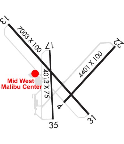
Runway Identifications
Runway Identification: 04/22Length: 4405 ft
Width: 100 ft
Surface: ASPHALT-FAIR CONDITION
Edge lights: Medium IntensityTreatment: NONE
| | Runway: 04 | | Runway: 22 |
| Mag heading: | 38° | Mag heading: | 218° |
| Rwy Slope: | .59% Up | Rwy Slope: | -.59% Down |
| Approach: | | Approach: | |
| Pattern: | Left Traffic | Pattern: | Left Traffic |
| Markings: | NONPRECISION INSTRUMENT | Markings: | NONPRECISION INSTRUMENT |
| Marking Condition: | GOOD | Marking Condition: | GOOD |
| Arresting Dev: | | Arresting Dev: | |
| Lat & Long: | N3803.7 W09751.6 | Lat. & Long.: | N3804.2 W09751.0 |
| Elev: | 1516.5 ft. MSL | Elev: | 1542.5 ft. MSL |
| TCH: | 44 ft. AGL | TCH: | 34 ft. AGL |
| Visual Glide Path: | 3.00 degrees | Visual Glide Path: | 3.40 degrees |
| Displaced Threshold: | No | Displaced Threshold: | No |
| Touchdown Zone: | YES | Touchdown Zone: | YES |
| Touchdown Elev.: | 1522.1 feet | Touchdown Elev.: | 1542.5 feet |
| Visual Glide Slope: | 4-Light PAPI on LEFT side of Runway | Visual Glide Slope: | 2-Box VASI on LEFT side of Runway |
| RVR Equipment: | | RVR Equipment: | |
| RVV Equipment: | NO | RVV Equipment: | NO |
| Approach Lights: | | Approach Lights: | |
| REIL: | YES | REIL: | YES |
| Centerline Lights: | NO | Centerline Lights: | NO |
| Touchdown lights: | NO | Touchdown lights: | NO |
| Runway Category: | Runway with a Non-precision Approach having visibility minimums greater than 3/4 mile | Runway Category: | Runway with a Non-precision Approach having visibility minimums greater than 3/4 mile |
| Declared Distances: | TORA:4401' TODA:4401' ASDA:4401' LDA:4401' | Declared Distances: | TORA:4401' TODA:4401' ASDA:4401' LDA:4401' |
| Obstructions: | | Obstructions: | GND |
| Marked: | | Marked: | NOT Marked/Lighted |
| Clearance slope: | 34:1 | Clearance slope: | 27:1 |
| Obstruction height: | | Obstruction height: | 83 feet AGL |
| Dist. from runway: | | Dist. from runway: | 2450 feet |
| Centerline offset: | | Centerline offset: | 450 feet left of centerline |
| Comments: | | Comments: | +5 FT GROUND 199 FT BOTH SIDES OF CNTRLN. |
Runway Identification: 13/31Length: 7003 ft
Width: 100 ft
Surface: ASPHALT
Edge lights: High IntensityTreatment: NONE
Weight: PCN 17 /F/D/X/T
| | Runway: 13 | | Runway: 31 |
| Mag heading: | 134° | Mag heading: | 314° |
| Rwy Slope: | -.15% Down | Rwy Slope: | .15% Up |
| Approach: | ILS | Approach: | |
| Pattern: | Left Traffic | Pattern: | Left Traffic |
| Markings: | PRECISION INSTRUMENT | Markings: | NONPRECISION INSTRUMENT |
| Marking Condition: | FAIR | Marking Condition: | FAIR |
| Arresting Dev: | | Arresting Dev: | |
| Lat & Long: | N3804.5 W09752.3 | Lat. & Long.: | N3803.6 W09751.3 |
| Elev: | 1524.9 ft. MSL | Elev: | 1514.7 ft. MSL |
| TCH: | | TCH: | 55 ft. AGL |
| Visual Glide Path: | | Visual Glide Path: | 3.00 degrees |
| Displaced Threshold: | No | Displaced Threshold: | No |
| Touchdown Zone: | YES | Touchdown Zone: | YES |
| Touchdown Elev.: | 1525.3 feet | Touchdown Elev.: | 1520.0 feet |
| Visual Glide Slope: | | Visual Glide Slope: | 4-BOX VASI ON LEFT SIDE OF RUNWAY |
| RVR Equipment: | TOUCHDOWN | RVR Equipment: | ROLLOUT |
| RVV Equipment: | YES | RVV Equipment: | NO |
| Approach Lights: | MALSR - 1,400 foot medium intensity approach lighting system with runway alignment indicator lights | Approach Lights: | |
| REIL: | NO | REIL: | YES |
| Centerline Lights: | NO | Centerline Lights: | NO |
| Touchdown lights: | NO | Touchdown lights: | NO |
| Runway Category: | Precision Instrument Runway | Runway Category: | D |
| Declared Distances: | TORA:7003' TODA:7003' ASDA:7003' LDA:7003' | Declared Distances: | TORA:7003' TODA:7003' ASDA:7003' LDA:7003' |
| Obstructions: | TREE | Obstructions: | |
| Marked: | NOT Marked/Lighted | Marked: | |
| Clearance slope: | 48:1 | Clearance slope: | 34:1 |
| Obstruction height: | 96 feet AGL | Obstruction height: | |
| Dist. from runway: | 4875 feet | Dist. from runway: | |
| Centerline offset: | 1000 left of centerline | Centerline offset: | |
| Comments: | | Comments: | |
Runway Identification: 17/35Length: 4012 ft
Width: 75 ft
Surface: CONCRETE
Edge lights: Medium IntensityTreatment: NONE
Weight: PCN 14 /R/B/W/T
| | Runway: 17 | | Runway: 35 |
| Mag heading: | 173° | Mag heading: | 353° |
| Rwy Slope: | -.14% Down | Rwy Slope: | .14% Up |
| Approach: | | Approach: | |
| Pattern: | Left Traffic | Pattern: | Left Traffic |
| Markings: | NONPRECISION INSTRUMENT | Markings: | NONPRECISION INSTRUMENT |
| Marking Condition: | GOOD | Marking Condition: | GOOD |
| Arresting Dev: | | Arresting Dev: | |
| Lat & Long: | N3804.2 W09751.8 | Lat. & Long.: | N3803.5 W09751.7 |
| Elev: | 1523.3 ft. MSL | Elev: | 1517.8 ft. MSL |
| TCH: | 40 ft. AGL | TCH: | 42 ft. AGL |
| Visual Glide Path: | 3.00 degrees | Visual Glide Path: | 3.00 degrees |
| Displaced Threshold: | No | Displaced Threshold: | No |
| Touchdown Zone: | YES | Touchdown Zone: | YES |
| Touchdown Elev.: | 1523.3 feet | Touchdown Elev.: | 1521.0 feet |
| Visual Glide Slope: | 4-Light PAPI on LEFT side of Runway | Visual Glide Slope: | 4-Light PAPI on LEFT side of Runway |
| RVR Equipment: | | RVR Equipment: | |
| RVV Equipment: | NO | RVV Equipment: | NO |
| Approach Lights: | | Approach Lights: | |
| REIL: | NO | REIL: | NO |
| Centerline Lights: | NO | Centerline Lights: | NO |
| Touchdown lights: | NO | Touchdown lights: | NO |
| Runway Category: | Runway with a Non-precision Approach having visibility minimums greater than 3/4 mile | Runway Category: | Runway with a Non-precision Approach having visibility minimums greater than 3/4 mile |
| Declared Distances: | TORA:4012' TODA:4012' ASDA:4012' LDA:4012' | Declared Distances: | TORA:4012' TODA:4012' ASDA:4012' LDA:4012' |
| Obstructions: | TREES | Obstructions: | |
| Marked: | NOT Marked/Lighted | Marked: | |
| Clearance slope: | 29:1 | Clearance slope: | 34:1 |
| Obstruction height: | 125 feet AGL | Obstruction height: | |
| Dist. from runway: | 3900 feet | Dist. from runway: | |
| Centerline offset: | 100 left of centerline | Centerline offset: | |
| Comments: | | Comments: | |