Click here for more info on on SMS!

KHUF

TERRE HAUTE INTL- HULMAN FLD
TERRE HAUTE
IN
Time Zone: Eastern
Lat: N 3927.0
Long: W 08718.4
Elev: 589
Var: +02
Longest Runway: 9021
Dept. ATIS: 127.5
Arr. ATIS: 127.5
Ground: 121.6
Tower: 134.72

FBO & Flight Services info for KHUF

FBOs: Update your Fuel Prices
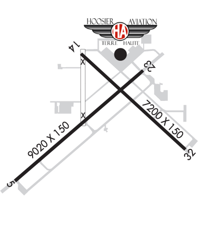
Hoosier Aviation at KHUF strives to provide the highest level of FBO service. Whether you are traveling in anything from a business jet to a vintage warbird we hope you will stop in to visit our completely remodeled facility. We offer a full array of services including flight training, de-ice, rental aircraft and on-field maintenance partner Williams Aviation. We welcome you to stop in today!
Ph: 812-877-7600 Fax: 812-877-7501 Freq: 122.95WebsiteE-Mail
                                       
Service
Jet
100LL
SAF
MoGas
Fuel Avail: After Hours and Holiday Call Out Fee $200. Please see our website for holiday closures.
Full6.556.73    Last Update: 04/23/2024 09:52
PRICES GUARANTEED by FBO.
Self        
Misc. Info: Avgas discount starts at 100 gallons, Jet Dicounts start at 500 gallons. Avfuel and Colt Contract.Address: 581 S. AIRPORT ST.,   TERRE HAUTE, IN 47803

ASOSPh: 812-877-9136
-
-
 
If you are an FBO, call 1-203-262-1700 to update your info or email: FltPlan.Advertising@garmin.com
Advertise your FBO on FltPlan.com

Runway & Approach Info for KHUF
Rwy
Length
Land Dist**
Approach*
  Rwy
Length
Land Dist**
Approach*
05
9021x150  9021'          
ILS
 109.70 - 049°  
  
23
  9021x150  9021'          
 
14
7200x150  7200'          
 
  
32
  7200x150  7200'          
 
 * only ILS, LOC, LDA, and SDF approaches to a specific runway are shown
** For any Declared Landing Distance Available, please see A/FD or Approach plates
Runway Weight Capability (lbs.) Help
Runway IDSingle WheelDouble WheelDouble Tandem WheelDual Double Wheel
05/2375,000200,000300,000600,000
14/3275,000200,000300,000N/A
These numbers are Advisory and are not limits.   The Airport Manager should have more accurate Weight Limits
Approach Charts
Approaches    
Current Weather/Notams
Customs Information Send updates to Support@FltPlan.com
Customs Not Available
Database effective 05/16/2024
Airport Diagram of KHUF
Airport Diagram might not be current.

Facility Name: TERRE HAUTE RGNL
City Name: TERRE HAUTE
County: VIGO
State abbrev: IN
State Name: INDIANA
   
Ownership: PUBLICLY OWNED
Use: OPEN TO THE PUBLIC
Owner's Name: TERRE HAUTE RGNL ARPT AUTH
Address: 581 S. AIRPORT ST.
 TERRE HAUTE, IN 47803
Owner's Phone: 812-877-2524
  
Manager's Name: JEFF HAUSER
Address: 581 S. AIRPORT ST.
 TERRE HAUTE, IN 47803
Phone: 812-877-2524
   
FAA Region: GREAT LAKES
FAA Field Office: CHI


Sunrise / Sunset times for TERRE HAUTE RGNL

DateSunriseSunset
04/23/24 Tuesday7:0020:36
04/24/24 Wednesday6:5820:37
04/25/24 Thursday6:5720:38
04/26/24 Friday6:5620:39
04/27/24 Saturday6:5420:40
04/28/24 Sunday6:5320:41
04/29/24 Monday6:5220:42
04/30/24 Tuesday6:5120:43
05/01/24 Wednesday6:4920:44
05/02/24 Thursday6:4820:45
05/03/24 Friday6:4720:46
05/04/24 Saturday6:4620:47
05/05/24 Sunday6:4520:48
05/06/24 Monday6:4420:49

Airport Facilities

Airport Attendance ScheduleCONTINUOUS
Airport Status OPERATIONAL (This Status can change at any time - please check NOTAMS)
Airport Lighting Schedule
Airport Storage AvailableTie Downs, Hanger
Extra Services AvailableAir Freight, Cargo Handling, Flight Instruction, Aircraft Rental
Wind IndicatorYES - (lighted)
Control TowerYES
CTAF Frequency
Unicom Frequency122.950
Rotating Beacon ColorWG
Segmented CircleNO
Landing FeeYES; LNDG FEE FOR CIVILIAN ACFT OVER 12,500 LBS.

Airport Inspection Data

Airport InspectedFEDERAL - performed by FAA AIRPORTS FIELD PERSONNEL
Inspection Date09/20/2023

Airport Services

Type of Fuel AvailableGrade 100LL, JET A (freeze point -40C)
Airframe Repair ServiceMAJOR
Power Plant Repair ServiceMAJOR

Geographic Data

LatitudeN3927.0
LongitudeW08718.4 (ESTIMATED)
Arpt Elevation589ft (SURVEYED)
Magnetic Variation02W
5 miles Eof TERRE HAUTE
Traffic Pattern Altitude
Sectional ChartST LOUIS

Aircraft Data

Operations (Reported)YearlyAvg. Daily
General Aviation Transient 2829978
General Aviation Local 41021112
Air Taxi 27017
Commerical 260
Commuter 00
Military 5922
Aircraft based on Field
General Aviation Singles 70
General Aviation Multi 7
Jet Aircraft 1
General Aviation Helicopters 0
Military Aircraft 0
Gliders 1
Ultralights 0

FAA Services

FSS on field NO
FSS tie-in TERRE HAUTE
FSS Phone 1-800-WX-BRIEF
Who issues Notams HUF
Notam D service at airport YES
ARTCC Name INDIANAPOLIS

Federal Status

Airport CertificationCLSD TO SKED ACR OPS GTR THAN 9 PSGR SEATS. UNSKED ACR OPS GTR THAN 30 PSGR SEATS RQR PPR - CTC 812-877-2524 OR 812-877-2252. INDEX B ARFF CAPABILITY AVBL ON REQ.
Aircraft Rescue & Firefighting IndexAIRPORT HAS A CERTIFICATE UNDER CFR PART 139
Airport of EntryNo
Custom Landing RightsNo; US CUSTOMS USER FEE ARPT.
Joint Civil/MilitaryNo
Military Landing rightsYES

Federal Agreements

NATIONAL PLAN OF INTEGRATED AIRPORT SYSTEMS (NPIAS)
GRANT AGREEMENTS UNDER FAAP/ADAP/AIP
ASSURANCES PURSUANT TO TITLE VI, CIVIL RIGHTS ACT OF 1964
AGREEMENT UNDER DLAND OR DCLA HAS EXPIRED.

Remarks

BIRDS ON & INVOF ARPT.
ACFT SVCS AVBL 2200 & 0600 SUBJECT TO AFTER-HRS CALLOUT FEE.
RWY 05/2 3 1000 FT PAVED BLAST PAD SW END & 1325 FT PAVED BLAST PAD NE END; RY 32 400 FT BY 150 FT BLAST PAD; NOT AVBL FOR ASDA.
Airport Communications & Frequencies:
ATIS Frequencies:   Hours(local) of Operation: CONTINUOUS
127.5
269.375
HULMAN Tower Frequencies:   Hours(local) of operation: CONTINUOUS   
134.725
322.475
HULMAN Ground Frequencies:
121.6
348.6
Emergency Frequencies:
243.0
Unicom Frequency:
122.950
HULMAN Primary Approach Frequencies:   Hours(local) of operation: CONTINUOUS   
125.45
339.8
Part-time Approach Frequencies:  
119.8
263.125
HULMAN Primary Departure Frequencies:   Hours(local) of operation: CONTINUOUS   
125.45
339.8
Part-time Departure Frequencies:  
119.8
263.125
Runway Identifications
Runway Identification: 05/23
Length: 9021 ft
Width: 150 ft
Surface: ASPHALT-FAIR CONDITION
Edge lights: High Intensity

Treatment: GROOVED
Weight: PCN 49 /R/C/W/U

 Runway: 05   Runway: 23
Mag heading: 49°Mag heading: 229°
Rwy Slope: .11% UpRwy Slope: -.11% Down
Approach: ILSApproach:
Pattern: Left TrafficPattern: Left Traffic
Markings: PRECISION INSTRUMENTMarkings: PRECISION INSTRUMENT
Marking Condition: FAIRMarking Condition: FAIR
Arresting Dev: Arresting Dev:
Lat & Long: N3926.4  W08719.4Lat. & Long.: N3927.4  W08718.0
Elev: 572.3 ft. MSLElev: 582.2 ft. MSL
TCH: 40 ft. AGLTCH: 50 ft. AGL
Visual Glide Path: 3.00 degreesVisual Glide Path: 3.00 degrees
Displaced Threshold: NoDisplaced Threshold: No
Touchdown Zone: YESTouchdown Zone: YES
Touchdown Elev.: 572.7 feetTouchdown Elev.: 582.3 feet
Visual Glide Slope: 4-Light PAPI on LEFT side of RunwayVisual Glide Slope: 4-Light PAPI on LEFT side of Runway
RVR Equipment: TOUCHDOWNRVR Equipment: ROLLOUT
RVV Equipment: NORVV Equipment: NO
Approach Lights: MALSR - 1,400 foot medium intensity approach lighting system with runway alignment indicator lightsApproach Lights:
REIL: NOREIL: YES
Centerline Lights: NOCenterline Lights: NO
Touchdown lights: NOTouchdown lights: NO
Runway Category: Precision Instrument RunwayRunway Category: D
Declared Distances: TORA:9020' TODA:9020' ASDA:9020' LDA:9020'Declared Distances: TORA:9020' TODA:9020' ASDA:9020' LDA:9020'
Obstructions: STACKObstructions: TREE
Marked: NOT Marked/LightedMarked: NOT Marked/Lighted
Clearance slope: 48:1Clearance slope: 29:1
Obstruction height: 54 feet AGLObstruction height: 71 feet AGL
Dist. from runway: 2841 feetDist. from runway: 2297 feet
Centerline offset: 412 left of centerlineCenterline offset: 535 feet right of centerline
Comments: Comments:
Runway Identification: 14/32
Length: 7200 ft
Width: 150 ft
Surface: CONCRETE ASPHALT-FAIR CONDITION
Edge lights: High Intensity

Treatment: GROOVED
Weight: PCN 42 /F/C/X/U

 Runway: 14   Runway: 32
Mag heading: 137°Mag heading: 317°
Rwy Slope: .29% UpRwy Slope: -.29% Down
Approach: Approach:
Pattern: Left TrafficPattern: Left Traffic
Markings: NONPRECISION INSTRUMENTMarkings: NONPRECISION INSTRUMENT
Marking Condition: GOODMarking Condition: GOOD
Arresting Dev: Arresting Dev:
Lat & Long: N3927.6  W08718.6Lat. & Long.: N3926.7  W08717.5
Elev: 568.0 ft. MSLElev: 589.1 ft. MSL
TCH: 59 ft. AGLTCH: 84 ft. AGL
Visual Glide Path: 2.75 degreesVisual Glide Path: 3.00 degrees
Displaced Threshold: NoDisplaced Threshold: No
Touchdown Zone: YESTouchdown Zone: YES
Touchdown Elev.: 578.7 feetTouchdown Elev.: 589.2 feet
Visual Glide Slope: 4-Light PAPI on LEFT side of RunwayVisual Glide Slope: 4-Light PAPI on LEFT side of Runway
RVR Equipment: RVR Equipment:
RVV Equipment: NORVV Equipment: NO
Approach Lights: Approach Lights:
REIL: YESREIL: YES
Centerline Lights: NOCenterline Lights: NO
Touchdown lights: NOTouchdown lights: NO
Runway Category: Runway with a Non-precision Approach having visibility minimums greater than 3/4 mileRunway Category: Runway with a Non-precision Approach having visibility minimums greater than 3/4 mile
Declared Distances: TORA:7200' TODA:7200' ASDA:7200' LDA:7200'Declared Distances: TORA:7200' TODA:7200' ASDA:7200' LDA:7200'
Obstructions: TREEObstructions:
Marked: NOT Marked/LightedMarked:
Clearance slope: 22:1Clearance slope: 50:1
Obstruction height: 105 feet AGLObstruction height:
Dist. from runway: 2597 feetDist. from runway:
Centerline offset: 341 left of centerlineCenterline offset:
Comments: Comments:
C:20/P: