Current Weather/Notams (Metars, TAFs, Notams, NWS Forecast, PIREPS, and nearby weather)
Customs Information Send updates to Support@FltPlan.com
Customs Not Available
Database effective 05/16/2024
Airport Diagram might not be current.
|
| Facility Name: | ROSCOMMON COUNTY/BLODGETT MEML |
| City Name: | HOUGHTON LAKE |
| County: | ROSCOMMON |
| State abbrev: | MI |
| State Name: | MICHIGAN |
| | |
| Ownership: | PUBLICLY OWNED |
| Use: | OPEN TO THE PUBLIC |
| Owner's Name: | ROSCOMMON COUNTY |
| Address: | 500 LAKE ST |
| | ROSCOMMON, MI 48653-7664 |
| Owner's Phone: | 989-275-8021 |
| | |
| Manager's Name: | ERIC J JAROCH |
| Address: | 5218 E HOUGHTON LAKE DR |
| | HOUGHTON LAKE, MI 48629-8313 |
| Phone: | 989-366-7660 |
| | |
| FAA Region: | GREAT LAKES |
| FAA Field Office: | DET |
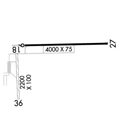
Runway Identifications
Runway Identification: 09/27Length: 4000 ft
Width: 75 ft
Surface: ASPHALT-GOOD CONDITION
Edge lights: High IntensityTreatment: NONE
| | Runway: 09 | | Runway: 27 |
| Mag heading: | 94° | Mag heading: | 274° |
| Rwy Slope: | -.08% Down | Rwy Slope: | .08% Up |
| Approach: | | Approach: | |
| Pattern: | Left Traffic | Pattern: | Left Traffic |
| Markings: | NONPRECISION INSTRUMENT | Markings: | NONPRECISION INSTRUMENT |
| Marking Condition: | GOOD | Marking Condition: | GOOD |
| Arresting Dev: | | Arresting Dev: | |
| Lat & Long: | N4421.7 W08440.4 | Lat. & Long.: | N4421.7 W08439.5 |
| Elev: | 1147.8 ft. MSL | Elev: | 1144.7 ft. MSL |
| TCH: | 32 ft. AGL | TCH: | 32 ft. AGL |
| Visual Glide Path: | 3.50 degrees | Visual Glide Path: | 3.50 degrees |
| Displaced Threshold: | No | Displaced Threshold: | No |
| Touchdown Zone: | YES | Touchdown Zone: | YES |
| Touchdown Elev.: | 1147.8 feet | Touchdown Elev.: | 1145.5 feet |
| Visual Glide Slope: | 4-Light PAPI on LEFT side of Runway | Visual Glide Slope: | 4-Light PAPI on RIGHT side of Runway |
| RVR Equipment: | | RVR Equipment: | |
| RVV Equipment: | NO | RVV Equipment: | NO |
| Approach Lights: | | Approach Lights: | |
| REIL: | YES | REIL: | YES |
| Centerline Lights: | NO | Centerline Lights: | NO |
| Touchdown lights: | NO | Touchdown lights: | NO |
| Runway Category: | Runway with a Non-precision Approach | Runway Category: | Runway with a Non-precision Approach |
| Declared Distances: | | Declared Distances: | |
| Obstructions: | TREES | Obstructions: | BRUSH |
| Marked: | NOT Marked/Lighted | Marked: | NOT Marked/Lighted |
| Clearance slope: | 20:1 | Clearance slope: | 9:1 |
| Obstruction height: | 65 feet AGL | Obstruction height: | 12 feet AGL |
| Dist. from runway: | 1545 feet | Dist. from runway: | 315 feet |
| Centerline offset: | 120 right of centerline | Centerline offset: | 130 feet left of centerline |
| Comments: | | Comments: | |
Runway Identification: 18/36Length: 2200 ft
Width: 100 ft
Surface: GRASS-GOOD CONDITION
Edge lights: Treatment: NONE
| | Runway: 18 | | Runway: 36 |
| Mag heading: | 183° | Mag heading: | 3° |
| Rwy Slope: | -.18% Down | Rwy Slope: | .18% Up |
| Approach: | | Approach: | |
| Pattern: | Left Traffic | Pattern: | Left Traffic |
| Markings: | | Markings: | |
| Marking Condition: | 3 FT YELLOW CONES. | Marking Condition: | 3 FT YELLOW CONES. |
| Arresting Dev: | | Arresting Dev: | |
| Lat & Long: | N4421.6 W08440.5 | Lat. & Long.: | N4421.3 W08440.5 |
| Elev: | 1148.3 ft. MSL | Elev: | 1144.3 ft. MSL |
| TCH: | | TCH: | |
| Visual Glide Path: | | Visual Glide Path: | |
| Displaced Threshold: | No | Displaced Threshold: | 200 feet |
| Touchdown Zone: | YES | Touchdown Zone: | YES |
| Touchdown Elev.: | 1149.7 feet | Touchdown Elev.: | 1149.7 feet |
| Visual Glide Slope: | | Visual Glide Slope: | |
| RVR Equipment: | | RVR Equipment: | |
| RVV Equipment: | NO | RVV Equipment: | NO |
| Approach Lights: | | Approach Lights: | |
| REIL: | NO | REIL: | NO |
| Centerline Lights: | NO | Centerline Lights: | NO |
| Touchdown lights: | NO | Touchdown lights: | NO |
| Runway Category: | Runway with a Visual Approach | Runway Category: | Runway with a Visual Approach |
| Declared Distances: | | Declared Distances: | |
| Obstructions: | TREE | Obstructions: | TREE |
| Marked: | NOT Marked/Lighted | Marked: | NOT Marked/Lighted |
| Clearance slope: | 18:1 | Clearance slope: | CTLG OBSTN EXCEEDS A 45 DEG SLP. APCH RATIO 13:1 TO DTHR OVR 23 FT TREE, 248 FT DIST, 156 FT R. |
| Obstruction height: | 99 feet AGL | Obstruction height: | 23 feet AGL |
| Dist. from runway: | 1815 feet | Dist. from runway: | 0 feet |
| Centerline offset: | 324 left of centerline | Centerline offset: | 156 feet right of centerline |
| Comments: | | Comments: | |