Current Weather/Notams (Metars, TAFs, Notams, NWS Forecast, PIREPS, and nearby weather)
Customs Information Send updates to Support@FltPlan.com
Customs Not Available
Database effective 05/16/2024
Airport Diagram might not be current. Facility Name: HASTINGS MUNI City Name: HASTINGS County: ADAMS State abbrev: NE State Name: NEBRASKA Ownership: PUBLICLY OWNED Use: OPEN TO THE PUBLIC Owner's Name: CITY OF HASTINGS Address: 220 N. HASTINGS AVENUE HASTINGS, NE 68901-5144 Owner's Phone: 402-984-5223 Manager's Name: MATTHEW KUHR Address: 220 N. HASTINGS AVENUE HASTINGS, NE 68901-5144 Phone: 402-984-5223; ARPT CELL- MON-FRI 0800-1700 (402) 705-2420. FAA Region: CENTRAL FAA Field Office: NONE
Runway Identifications Help
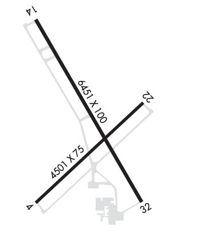
Runway Identification: 04/22 Length: 4501 ftWidth: 75 ftSurface: CONCRETE-GOOD CONDITIONEdge lights: Medium Intensity Treatment: NONE Runway: 04 Runway: 22 Mag heading: 40° Mag heading: 220° Rwy Slope: .18% Up Rwy Slope: -.18% Down Approach: Approach: Pattern: Left Traffic Pattern: Left Traffic Markings: NONPRECISION INSTRUMENT Markings: BASIC Marking Condition: GOOD Marking Condition: GOOD Arresting Dev: Arresting Dev: Lat & Long: N4035.9 W09826.0 Lat. & Long.: N4036.4 W09825.3 Elev: 1939.4 ft. MSL Elev: 1947.5 ft. MSL TCH: 40 ft. AGL TCH: 40 ft. AGL Visual Glide Path: 3.00 degrees Visual Glide Path: 3.00 degrees Displaced Threshold: No Displaced Threshold: No Touchdown Zone: YES Touchdown Zone: YES Touchdown Elev.: 1943.7 feet Touchdown Elev.: 1947.5 feet Visual Glide Slope: 2-Light PAPI on LEFT side of Runway Visual Glide Slope: 2-Light PAPI on LEFT side of Runway RVR Equipment: RVR Equipment: RVV Equipment: NO RVV Equipment: NO Approach Lights: Approach Lights: REIL: NO REIL: NO Centerline Lights: NO Centerline Lights: NO Touchdown lights: NO Touchdown lights: NO Runway Category: Runway with a Non-precision Approach having visibility minimums greater than 3/4 mile Runway Category: Runway with a Visual Approach Declared Distances: Declared Distances:
Runway Identification: 14/32 Length: 6451 ftWidth: 100 ftSurface: CONCRETE-GOOD CONDITIONEdge lights: Medium Intensity Treatment: NONE Runway: 14 Runway: 32 Mag heading: 143° Mag heading: 323° Rwy Slope: -.36% Down Rwy Slope: .36% Up Approach: Approach: Pattern: Left Traffic Pattern: Left Traffic Markings: NONPRECISION INSTRUMENT Markings: NONPRECISION INSTRUMENT Marking Condition: GOOD Marking Condition: GOOD Arresting Dev: Arresting Dev: Lat & Long: N4036.9 W09826.0 Lat. & Long.: N4035.9 W09825.3 Elev: 1961.2 ft. MSL Elev: 1938.0 ft. MSL TCH: 38 ft. AGL TCH: 42 ft. AGL Visual Glide Path: 3.00 degrees Visual Glide Path: 3.00 degrees Displaced Threshold: No Displaced Threshold: 950 feet Touchdown Zone: YES Touchdown Zone: YES Touchdown Elev.: 1961.2 feet Touchdown Elev.: 1943.8 feet Visual Glide Slope: 4-Light PAPI on LEFT side of Runway Visual Glide Slope: 4-Light PAPI on RIGHT side of Runway RVR Equipment: RVR Equipment: RVV Equipment: NO RVV Equipment: NO Approach Lights: Approach Lights: REIL: YES REIL: YES Centerline Lights: NO Centerline Lights: NO Touchdown lights: NO Touchdown lights: NO Runway Category: Runway with a Non-precision Approach having visibility minimums greater than 3/4 mile Runway Category: Runway with a Non-precision Approach having visibility minimums greater than 3/4 mile Declared Distances: TORA:5500' TODA:6451' ASDA:5500' LDA:5500' Declared Distances: TORA:6451' TODA:6451' ASDA:6451' LDA:5500' Obstructions: TOWER Obstructions: ROAD Marked: NOT Marked/Lighted Marked: NOT Marked/Lighted Clearance slope: 46:1; APCH RATIO 48:1 DUE TO RR TWR 35 FT ABV & 1884 FT FM RWY END; 166 L. Clearance slope: 11:1; APCH RATIO FM DSPLCD THR 50:1. Obstruction height: 36 feet AGL Obstruction height: 14 feet AGL Dist. from runway: 1884 feet Dist. from runway: 364 feet Centerline offset: 165 left of centerline Centerline offset: 275 feet right of centerline Comments: Comments: