Click here for more info on on SMS!

KHSE

BILLY MITCHELL
HATTERAS
NC
Time Zone: Eastern
Lat: N 3514.0
Long: W 07537.1
Elev: 16
Var: +10
Longest Runway: 3002
AWOS: 118.37
CTAF: 122.9

FBO & Flight Services info for KHSE

FBOs: Update your Fuel Prices

AIRPORTPh: 919-814-0550
-
Freq: 122.9
Service
Jet
100LL
SAF
MoGas
Fuel Avail: NO FUEL AVAILABLE
Full        Last Update: 04/23/2024 05:40:08

Self        
ASOSPh: 252-995-3646
-
Freq: 118.37  
If you are an FBO, call 1-203-262-1700 to update your info or email: FltPlan.Advertising@garmin.com
Advertise your FBO on FltPlan.com

Runway & Approach Info for KHSE
Rwy
Length
Land Dist**
Approach*
  Rwy
Length
Land Dist**
Approach*
07
3002x75  3002'          
 
  
25
  3002x75  3002'          
 
 * only ILS, LOC, LDA, and SDF approaches to a specific runway are shown
** For any Declared Landing Distance Available, please see A/FD or Approach plates
Runway Weight Capability (lbs.) Help
Runway IDSingle WheelDouble WheelDouble Tandem WheelDual Double Wheel
07/2530,000N/AN/AN/A
These numbers are Advisory and are not limits.   The Airport Manager should have more accurate Weight Limits
Approach Charts
Approaches    
Current Weather/Notams
Customs Information Send updates to Support@FltPlan.com
Customs Not Available
Database effective 05/16/2024
Airport Diagram of KHSE
Airport Diagram might not be current.

Facility Name: BILLY MITCHELL
City Name: HATTERAS
County: DARE
State abbrev: NC
State Name: NORTH CAROLINA
   
Ownership: PUBLICLY OWNED
Use: OPEN TO THE PUBLIC
Owner's Name: NATIONAL PARK SERVICE; ARPT UNDER LEASE TO NC DOT UNDER SPECIAL-USE PERMIT; CTC NR 919-814-0550.
Address: 1401 NATIONAL PARK DR
 MANTEO, NC 27954
Owner's Phone: 252-475-9000
  
Manager's Name: BOONE VANDZURA
Address: 1401 NATIONAL PARK DRIVE
 MANTEO, NC 27954
Phone: 252-475-9000; NTL PARKS SVC NR ANSWERED 7 DAYS A WEEK BTWN 0800 TO 1700.
   
FAA Region: SOUTHERN
FAA Field Office: MEM


Sunrise / Sunset times for BILLY MITCHELL

DateSunriseSunset
04/22/24 Monday6:2119:42
04/23/24 Tuesday6:1919:42
04/24/24 Wednesday6:1819:43
04/25/24 Thursday6:1719:44
04/26/24 Friday6:1619:45
04/27/24 Saturday6:1519:46
04/28/24 Sunday6:1419:47
04/29/24 Monday6:1319:47
04/30/24 Tuesday6:1219:48
05/01/24 Wednesday6:1019:49
05/02/24 Thursday6:0919:50
05/03/24 Friday6:0819:51
05/04/24 Saturday6:0719:51
05/05/24 Sunday6:0619:52

Airport Facilities

Airport Attendance ScheduleUNATTENDED
Airport Status OPERATIONAL (This Status can change at any time - please check NOTAMS)
Airport Lighting Schedule
Airport Storage AvailableTie Downs
Extra Services AvailableNONE
Wind IndicatorYES - (unlit)
Control TowerNO
CTAF Frequency122.900
Unicom Frequency
Rotating Beacon Color
Segmented CircleYES
Landing FeeNO

Airport Inspection Data

Airport InspectedSTATE - performed by STATE AERONAUTICAL PERSONNEL
Inspection Date09/02/2022

Airport Services

Type of Fuel AvailableNone
Airframe Repair ServiceNONE
Power Plant Repair ServiceNONE

Geographic Data

LatitudeN3514.0
LongitudeW07537.1 (ESTIMATED)
Arpt Elevation16ft (SURVEYED)
Magnetic Variation10W
4 miles Eof HATTERAS
Traffic Pattern Altitude
Sectional ChartCHARLOTTE

Aircraft Data

Operations (Reported)YearlyAvg. Daily
General Aviation Transient 500014
General Aviation Local 400011
Air Taxi 1000
Commerical 00
Commuter 00
Military 1000
Aircraft based on Field
General Aviation Singles 0
General Aviation Multi 0
Jet Aircraft 0
General Aviation Helicopters 0
Military Aircraft 0
Gliders 0
Ultralights 0

FAA Services

FSS on field NO
FSS tie-in RALEIGH
FSS Phone 1-800-WX-BRIEF
Who issues Notams HSE
Notam D service at airport YES
ARTCC Name WASHINGTON

Federal Status

Airport Certification
Aircraft Rescue & Firefighting IndexNone
Airport of EntryNo
Custom Landing RightsNo
Joint Civil/MilitaryNo
Military Landing rightsNo

Federal Agreements

NATIONAL PLAN OF INTEGRATED AIRPORT SYSTEMS (NPIAS)

Remarks

+10-35 FT SAND DUNES AND SCRUB TREES BOTH SIDES OF RWY WITHIN ROFA.
ARPT CLSD 30 MIN AFTER SS TIL 30 MIN BEFORE SR. ALL NIGHTTIME OPNS PROHIBITED.
HIGH SPEED LOW LEVEL MIL OPNS IN VIC OF ARPT.
FLOCKS OF SEAGULLS ON & INVOF OF ARPT.
RWY 07/25 SAFETY AREA IS LOOSE SAND & DUNES - NOT SUITABLE FOR ACFT.
ADDITIONAL ACFT PARKING AVBL ON MID-FIELD APRON.
ARPT LCTD IN CAPE HATTERAS NTL SEASHORE. MNTN 2000 FT VER & HORIZONTAL DIST FM SEASHORE BEACHES.
FOR CD CTC CHERRY POINT APCH AT 252-466-5960.
Airport Communications & Frequencies:
CTAF Frequency:
122.900
Remarks
  • COMMUNICATIONS PRVDD BY RALEIGH RADIO ON FREQ 122.3 (HATTERAS RCO).
  • CHERRY POINT Primary Approach Frequencies:  
    119.75
    360.775
    CHERRY POINT Primary Departure Frequencies:  
    119.75
    360.775
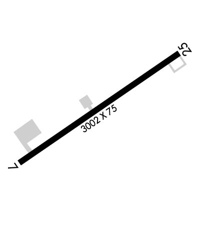
    Runway Identifications
    Runway Identification: 07/25
    Length: 3002 ft
    Width: 75 ft
    Surface: ASPHALT-FAIR CONDITION
    Edge lights:

    Treatment: NONE

     Runway: 07   Runway: 25
    Mag heading: 67°Mag heading: 247°
    Rwy Slope: .25% UpRwy Slope: -.25% Down
    Approach: Approach:
    Pattern: Left TrafficPattern: Left Traffic
    Markings: NONPRECISION INSTRUMENTMarkings: NONPRECISION INSTRUMENT
    Marking Condition: FAIRMarking Condition: FAIR
    Arresting Dev: Arresting Dev:
    Lat & Long: N3513.8  W07537.3Lat. & Long.: N3514.1  W07536.8
    Elev: 8.6 ft. MSLElev: 16.1 ft. MSL
    TCH: TCH:
    Visual Glide Path: Visual Glide Path:
    Displaced Threshold: NoDisplaced Threshold: No
    Touchdown Zone: YESTouchdown Zone: YES
    Touchdown Elev.: 16.3 feetTouchdown Elev.: 16.3 feet
    Visual Glide Slope: Visual Glide Slope:
    RVR Equipment: RVR Equipment:
    RVV Equipment: NORVV Equipment: NO
    Approach Lights: Approach Lights:
    REIL: NOREIL: NO
    Centerline Lights: NOCenterline Lights: NO
    Touchdown lights: NOTouchdown lights: NO
    Runway Category: Runway with a Non-precision ApproachRunway Category: Runway with a Non-precision Approach
    Declared Distances: Declared Distances:
    Obstructions: BRUSHObstructions: TREE
    Marked: NOT Marked/LightedMarked: NOT Marked/Lighted
    Clearance slope: 14:1Clearance slope: 2:1
    Obstruction height: 14 feet AGLObstruction height: 29 feet AGL
    Dist. from runway: 399 feetDist. from runway: 277 feet
    Centerline offset: 154 left of centerlineCenterline offset: 145 feet right of centerline
    Comments: 11 FT SAND DUNES 38 FT FM THR 108 FT R OF CNTRLN, AND 11 FT SAND DUNES 0-200 FT FM THR 108 FT L OF CNTRLN.Comments: 8 FT DUNE 57 FT FM THR 117 FT L OF CNTRLN; 15 FT WINDSOCK 72 FT FM THR 221 FT L OF CNTRLN; AND 28 FT TREES 0-100 FT FM THR 159 FT R OF CNTRLN.
    C:4/P: