Current Weather/Notams (Metars, TAFs, Notams, NWS Forecast, PIREPS, and nearby weather)
Customs Information Send updates to Support@FltPlan.com
Customs Not Available
Database effective 04/18/2024
Airport Diagram might not be current.
|
| Facility Name: | HARRISBURG-RALEIGH |
| City Name: | HARRISBURG |
| County: | SALINE |
| State abbrev: | IL |
| State Name: | ILLINOIS |
| | |
| Ownership: | PUBLICLY OWNED |
| Use: | OPEN TO THE PUBLIC |
| Owner's Name: | HARRISBURG RALEIGH AIRPORT |
| Address: | P.O. BOX 33 |
| | HARRISBURG, IL 62946 |
| Owner's Phone: | 618-253-7806 |
| | |
| Manager's Name: | DALE SHELTON |
| Address: | P.O. BOX 33; EMAIL ADDRESS: DSHELTON1018@GMAIL.COM (ALL LOWER CASE) |
| | HARRISBURG, IL 62946 |
| Phone: | 618-253-7806 |
| | |
| FAA Region: | GREAT LAKES |
| FAA Field Office: | CHI |
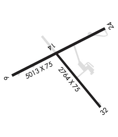
Runway Identifications
Runway Identification: 06/24Length: 5013 ft
Width: 75 ft
Surface: ASPHALT-FAIR CONDITION
Edge lights: Medium IntensityTreatment: NONE
| | Runway: 06 | | Runway: 24 |
| Mag heading: | 63° | Mag heading: | 243° |
| Rwy Slope: | .19% Up | Rwy Slope: | -.19% Down |
| Approach: | | Approach: | |
| Pattern: | Left Traffic | Pattern: | Left Traffic |
| Markings: | NONPRECISION INSTRUMENT | Markings: | NONPRECISION INSTRUMENT |
| Marking Condition: | GOOD | Marking Condition: | GOOD |
| Arresting Dev: | | Arresting Dev: | |
| Lat & Long: | N3748.5 W08833.6 | Lat. & Long.: | N3748.9 W08832.6 |
| Elev: | 386.7 ft. MSL | Elev: | 396.2 ft. MSL |
| TCH: | 35 ft. AGL | TCH: | 35 ft. AGL |
| Visual Glide Path: | 3.00 degrees | Visual Glide Path: | 3.00 degrees |
| Displaced Threshold: | No | Displaced Threshold: | No |
| Touchdown Zone: | YES | Touchdown Zone: | YES |
| Touchdown Elev.: | 393.9 feet | Touchdown Elev.: | 396.2 feet |
| Visual Glide Slope: | 4-Light PAPI on LEFT side of Runway | Visual Glide Slope: | 4-Light PAPI on LEFT side of Runway |
| RVR Equipment: | | RVR Equipment: | |
| RVV Equipment: | NO | RVV Equipment: | NO |
| Approach Lights: | | Approach Lights: | |
| REIL: | YES | REIL: | YES |
| Centerline Lights: | NO | Centerline Lights: | NO |
| Touchdown lights: | NO | Touchdown lights: | NO |
| Runway Category: | Runway with a Non-precision Approach having visibility minimums greater than 3/4 mile | Runway Category: | Runway with a Non-precision Approach having visibility minimums greater than 3/4 mile |
| Declared Distances: | | Declared Distances: | |
| Obstructions: | | Obstructions: | TREE |
| Marked: | | Marked: | NOT Marked/Lighted |
| Clearance slope: | 34:1 | Clearance slope: | 16:1 |
| Obstruction height: | | Obstruction height: | 31 feet AGL |
| Dist. from runway: | | Dist. from runway: | 721 feet |
| Centerline offset: | | Centerline offset: | 179 feet left of centerline |
| Comments: | | Comments: | |
Runway Identification: 14/32Length: 2764 ft
Width: 75 ft
Surface: ASPHALT-GOOD CONDITION
Edge lights: Medium IntensityTreatment: NONE
| | Runway: 14 | | Runway: 32 |
| Mag heading: | 141° | Mag heading: | 321° |
| Rwy Slope: | -.20% Down | Rwy Slope: | .20% Up |
| Approach: | | Approach: | |
| Pattern: | Left Traffic | Pattern: | Left Traffic |
| Markings: | BASIC | Markings: | BASIC |
| Marking Condition: | FAIR | Marking Condition: | FAIR |
| Arresting Dev: | | Arresting Dev: | |
| Lat & Long: | N3748.8 W08833.0 | Lat. & Long.: | N3748.4 W08832.7 |
| Elev: | 387.4 ft. MSL | Elev: | 381.9 ft. MSL |
| TCH: | | TCH: | |
| Visual Glide Path: | | Visual Glide Path: | |
| Displaced Threshold: | No | Displaced Threshold: | No |
| Touchdown Zone: | YES | Touchdown Zone: | YES |
| Touchdown Elev.: | 387.4 feet | Touchdown Elev.: | 387.4 feet |
| Visual Glide Slope: | | Visual Glide Slope: | |
| RVR Equipment: | | RVR Equipment: | |
| RVV Equipment: | NO | RVV Equipment: | NO |
| Approach Lights: | | Approach Lights: | |
| REIL: | NO | REIL: | NO |
| Centerline Lights: | NO | Centerline Lights: | NO |
| Touchdown lights: | NO | Touchdown lights: | NO |
| Runway Category: | Runway with a Visual Approach | Runway Category: | Runway with a Visual Approach |
| Declared Distances: | | Declared Distances: | |

