Current Weather/Notams (Metars, TAFs, Notams, NWS Forecast, PIREPS, and nearby weather)
Customs Information Send updates to Support@FltPlan.com
Customs Not Available
Database effective 04/18/2024
Airport Diagram might not be current.
|
| Facility Name: | HEREFORD MUNI |
| City Name: | HEREFORD |
| County: | DEAF SMITH |
| State abbrev: | TX |
| State Name: | TEXAS |
| | |
| Ownership: | PUBLICLY OWNED |
| Use: | OPEN TO THE PUBLIC |
| Owner's Name: | CITY OF HEREFORD |
| Address: | BOX 2277 |
| | HEREFORD, TX 79045 |
| Owner's Phone: | 806-363-7100 |
| | |
| Manager's Name: | CAYDEN FINCH |
| Address: | 4175 US HWY 60 |
| | HEREFORD, TX 79045 |
| Phone: | 806-344-7710 |
| | |
| FAA Region: | SOUTHWEST |
| FAA Field Office: | TEX |
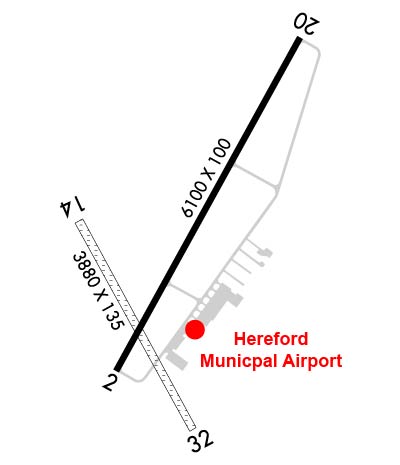
Runway Identifications
Runway Identification: 02/20Length: 6100 ft
Width: 100 ft
Surface: CONCRETE
Edge lights: Medium IntensityTreatment: GROOVED
| | Runway: 02 | | Runway: 20 |
| Mag heading: | 20° | Mag heading: | 200° |
| Rwy Slope: | .00% | Rwy Slope: | .00% |
| Approach: | | Approach: | |
| Pattern: | Left Traffic | Pattern: | Left Traffic |
| Markings: | NONPRECISION INSTRUMENT | Markings: | NONPRECISION INSTRUMENT |
| Marking Condition: | GOOD | Marking Condition: | GOOD |
| Arresting Dev: | | Arresting Dev: | |
| Lat & Long: | N3451.3 W10219.8 | Lat. & Long.: | N3452.2 W10219.2 |
| Elev: | 3786.2 ft. MSL | Elev: | 3786.2 ft. MSL |
| TCH: | 52 ft. AGL | TCH: | 48 ft. AGL |
| Visual Glide Path: | 3.00 degrees | Visual Glide Path: | 3.00 degrees |
| Displaced Threshold: | No | Displaced Threshold: | No |
| Touchdown Zone: | YES | Touchdown Zone: | YES |
| Touchdown Elev.: | 3786.2 feet | Touchdown Elev.: | 3786.2 feet |
| Visual Glide Slope: | 4-Light PAPI on LEFT side of Runway | Visual Glide Slope: | 4-Light PAPI on LEFT side of Runway |
| RVR Equipment: | | RVR Equipment: | |
| RVV Equipment: | NO | RVV Equipment: | NO |
| Approach Lights: | | Approach Lights: | |
| REIL: | NO | REIL: | NO |
| Centerline Lights: | NO | Centerline Lights: | NO |
| Touchdown lights: | NO | Touchdown lights: | NO |
| Runway Category: | D | Runway Category: | D |
| Declared Distances: | | Declared Distances: | |
| Obstructions: | PLINE | Obstructions: | |
| Marked: | NOT Marked/Lighted | Marked: | |
| Clearance slope: | 47:1 | Clearance slope: | 50:1 |
| Obstruction height: | 45 feet AGL | Obstruction height: | |
| Dist. from runway: | 2335 feet | Dist. from runway: | |
| Centerline offset: | 596 left of centerline | Centerline offset: | |
| Comments: | | Comments: | |
Runway Identification: 14/32Length: 3807 ft
Width: 135 ft
Surface: GRASS-POOR CONDITION
Edge lights: Treatment: NONE
| | Runway: 14 | | Runway: 32 |
| Mag heading: | 142° | Mag heading: | 322° |
| Rwy Slope: | .00% | Rwy Slope: | .00% |
| Approach: | | Approach: | |
| Pattern: | Left Traffic | Pattern: | Left Traffic |
| Markings: | | Markings: | |
| Marking Condition: | POOR; 14/32 THRS MKD WITH CONCRETE MARKERS. | Marking Condition: | POOR |
| Arresting Dev: | | Arresting Dev: | |
| Lat & Long: | N3451.7 W10219.9 | Lat. & Long.: | N3451.2 W10219.5 |
| Elev: | 3783.0 ft. MSL | Elev: | 3783.0 ft. MSL |
| TCH: | | TCH: | |
| Visual Glide Path: | | Visual Glide Path: | |
| Displaced Threshold: | No | Displaced Threshold: | No |
| Touchdown Zone: | YES | Touchdown Zone: | YES |
| Touchdown Elev.: | 3783.0 feet | Touchdown Elev.: | 3783.0 feet |
| Visual Glide Slope: | | Visual Glide Slope: | |
| RVR Equipment: | | RVR Equipment: | |
| RVV Equipment: | NO | RVV Equipment: | NO |
| Approach Lights: | | Approach Lights: | |
| REIL: | NO | REIL: | NO |
| Centerline Lights: | NO | Centerline Lights: | NO |
| Touchdown lights: | NO | Touchdown lights: | NO |
| Runway Category: | Runway with a Visual Approach | Runway Category: | Runway with a Visual Approach |
| Declared Distances: | | Declared Distances: | |
| Obstructions: | PLINE | Obstructions: | PLINE |
| Marked: | NOT Marked/Lighted | Marked: | NOT Marked/Lighted |
| Clearance slope: | 28:1 | Clearance slope: | 24:1 |
| Obstruction height: | 50 feet AGL | Obstruction height: | 50 feet AGL |
| Dist. from runway: | 1400 feet | Dist. from runway: | 1200 feet |
| Centerline offset: | 280 right of centerline | Centerline offset: | |
| Comments: | | Comments: | |


