
| ||||||||||||||||||||||||||||||||||||||||||||
| ||||||||||||||||||||||||||||||||||||||||||||
| ||||||||||||||||||||||||||||||||||||||||||||
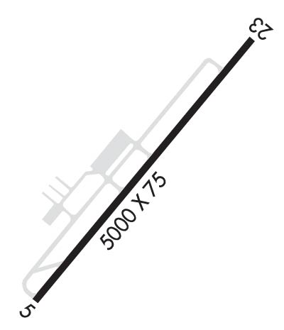
| Rwy | Rwy | |||||||
| 5005x75 | 5005' | 108.35 - 047° | 5005x75 | 5005' | ||||
| Runway ID | Single Wheel | Double Wheel | Double Tandem Wheel | Dual Double Wheel |
| 05/23 | 45,000 | 60,000 | N/A | N/A |
| These numbers are Advisory and are not limits. The Airport Manager should have more accurate Weight Limits | ||||
 Airport Diagram might not be current. | |
| Facility Name: | HARNETT RGNL JETPORT |
| City Name: | ERWIN |
| County: | HARNETT |
| State abbrev: | NC |
| State Name: | NORTH CAROLINA |
| Ownership: | PUBLICLY OWNED |
| Use: | OPEN TO THE PUBLIC |
| Owner's Name: | HARNETT COUNTY |
| Address: | 200 ALEXANDER DRIVE, 108 E. FRONT STREET |
| LILLINGTON, NC 27546 | |
| Owner's Phone: | 910-814-2740; COLEY PRICE, ASST COUNTY MGR. |
| Manager's Name: | GREG FRANK |
| Address: | 615 AIRPORT RD |
| ERWIN, NC 28339 | |
| Phone: | 910-814-2740 |
| FAA Region: | SOUTHERN |
| FAA Field Office: | MEM |
| Date | Sunrise | Sunset |
|---|---|---|
| 04/17/24 Wednesday | 6:39 | 19:50 |
| 04/18/24 Thursday | 6:38 | 19:51 |
| 04/19/24 Friday | 6:37 | 19:52 |
| 04/20/24 Saturday | 6:35 | 19:53 |
| 04/21/24 Sunday | 6:34 | 19:53 |
| 04/22/24 Monday | 6:33 | 19:54 |
| 04/23/24 Tuesday | 6:32 | 19:55 |
| 04/24/24 Wednesday | 6:30 | 19:56 |
| 04/25/24 Thursday | 6:29 | 19:57 |
| 04/26/24 Friday | 6:28 | 19:58 |
| 04/27/24 Saturday | 6:27 | 19:58 |
| 04/28/24 Sunday | 6:26 | 19:59 |
| 04/29/24 Monday | 6:25 | 20:00 |
| 04/30/24 Tuesday | 6:24 | 20:01 |
| Airport Attendance Schedule | 7 Days A Week 0800-1700 |
| Airport Status | OPERATIONAL (This Status can change at any time - please check NOTAMS) |
| Airport Lighting Schedule | ACTVT REIL RWY 05 & RWY 23; MIRL RWY 05/23 - CTAF; PAPI RWY 05 & RWY 23 ON CONSLY. |
| Airport Storage Available | Tie Downs, Hanger |
| Extra Services Available | Air Ambulance, Flight Instruction, Aircraft Rental |
| Wind Indicator | YES - (lighted) |
| Control Tower | NO |
| CTAF Frequency | 122.700 |
| Unicom Frequency | 122.700 |
| Rotating Beacon Color | WG |
| Segmented Circle | YES |
| Landing Fee | NO |
| Airport Inspected | STATE - performed by STATE AERONAUTICAL PERSONNEL |
| Inspection Date | 08/12/2022 |
| Type of Fuel Available | Grade 100LL, JET A-1 (icing inhibitor, freeze point -50C); -10100LL 24 HR. SELF SVC WITH CREDIT CARD. |
| Airframe Repair Service | MAJOR |
| Power Plant Repair Service | MAJOR |
| Latitude | N3522.8 |
| Longitude | W07843.9 (ESTIMATED) |
| Arpt Elevation | 201ft (SURVEYED) |
| Magnetic Variation | 08W |
| 4 miles NW | of ERWIN |
| Traffic Pattern Altitude | |
| Sectional Chart | CHARLOTTE |
| Operations (Reported) | Yearly | Avg. Daily |
|---|---|---|
| General Aviation Transient | 14000 | 38 |
| General Aviation Local | 30000 | 82 |
| Air Taxi | 300 | 1 |
| Commerical | 0 | 0 |
| Commuter | 0 | 0 |
| Military | 7000 | 19 |
| Aircraft based on Field | |
|---|---|
| General Aviation Singles | 32 |
| General Aviation Multi | 3 |
| Jet Aircraft | 1 |
| General Aviation Helicopters | 1 |
| Military Aircraft | 0 |
| Gliders | 0 |
| Ultralights | 1 |
| FSS on field | NO |
| FSS tie-in | RALEIGH |
| FSS Phone | 1-800-WX-BRIEF |
| Who issues Notams | HRJ |
| Notam D service at airport | YES |
| ARTCC Name | WASHINGTON |
| Airport Certification | |
| Aircraft Rescue & Firefighting Index | None |
| Airport of Entry | No |
| Custom Landing Rights | No |
| Joint Civil/Military | No |
| Military Landing rights | YES |
| NATIONAL PLAN OF INTEGRATED AIRPORT SYSTEMS (NPIAS) |
| GRANT AGREEMENTS UNDER FAAP/ADAP/AIP |
| ASSURANCES PURSUANT TO TITLE VI, CIVIL RIGHTS ACT OF 1964 |
| RWY 05, 60 FT DROP-OFF 350 FT FM THR & RWY 23, 25 FT DROP-OFF 70 FT LEFT OF CNTRLN. |
| FOR CD CTC FAYETTEVILLE APCH AT 910-484-8012. |
| SVC AVBL 24/7 WITH PRIOR ARNGMNTS. GPU AND BULK OIL AVBL. |
| ARPT LOCATED 18 NM NE OF POPE ARMY AIRFIELD, LOW LEVEL MIL ACT INVOF ARPT. |
| ROTG BCN OBSC BY TREES N & W OF ARPT. |
Airport Communications & Frequencies:
| ||||||||||||||||
| Runway: 05 | Runway: 23 | ||
| Mag heading: | 48° | Mag heading: | 228° |
| Rwy Slope: | .28% Up | Rwy Slope: | -.28% Down |
| Approach: | LOC/DME | Approach: | |
| Pattern: | Left Traffic | Pattern: | Left Traffic |
| Markings: | NONPRECISION INSTRUMENT | Markings: | NONPRECISION INSTRUMENT |
| Marking Condition: | GOOD | Marking Condition: | GOOD |
| Arresting Dev: | Arresting Dev: | ||
| Lat & Long: | N3522.5 W07844.3 | Lat. & Long.: | N3523.1 W07843.6 |
| Elev: | 187.9 ft. MSL | Elev: | 201.7 ft. MSL |
| TCH: | 39 ft. AGL | TCH: | 39 ft. AGL |
| Visual Glide Path: | 3.00 degrees | Visual Glide Path: | 3.00 degrees |
| Displaced Threshold: | No | Displaced Threshold: | No |
| Touchdown Zone: | YES | Touchdown Zone: | YES |
| Touchdown Elev.: | 195.5 feet | Touchdown Elev.: | 201.7 feet |
| Visual Glide Slope: | 2-Light PAPI on LEFT side of Runway | Visual Glide Slope: | 2-Light PAPI on LEFT side of Runway |
| RVR Equipment: | RVR Equipment: | ||
| RVV Equipment: | NO | RVV Equipment: | NO |
| Approach Lights: | Approach Lights: | ||
| REIL: | YES | REIL: | YES |
| Centerline Lights: | NO | Centerline Lights: | NO |
| Touchdown lights: | NO | Touchdown lights: | NO |
| Runway Category: | Runway with a Non-precision Approach having visibility minimums greater than 3/4 mile | Runway Category: | Runway with a Non-precision Approach having visibility minimums greater than 3/4 mile |
| Declared Distances: | Declared Distances: | ||
| Obstructions: | Obstructions: | TREES | |
| Marked: | Marked: | NOT Marked/Lighted | |
| Clearance slope: | 50:1 | Clearance slope: | 24:1 |
| Obstruction height: | Obstruction height: | 96 feet AGL | |
| Dist. from runway: | Dist. from runway: | 2593 feet | |
| Centerline offset: | Centerline offset: | 172 feet right of centerline | |
| Comments: | Comments: |
