Current Weather/Notams (Metars, TAFs, Notams, NWS Forecast, PIREPS, and nearby weather)
Customs Information Send updates to Support@FltPlan.com
Customs Not Available
Database effective 05/16/2024
Airport Diagram might not be current.
|
| Facility Name: | HUGOTON MUNI |
| City Name: | HUGOTON |
| County: | STEVENS |
| State abbrev: | KS |
| State Name: | KANSAS |
| | |
| Ownership: | PUBLICLY OWNED |
| Use: | OPEN TO THE PUBLIC |
| Owner's Name: | STEVENS COUNTY |
| Address: | P.O. BOX 130 |
| | HUGOTON, KS 67951 |
| Owner's Phone: | (620) 544-6331 |
| | |
| Manager's Name: | SCOTT SPIKES; ROBERT DAVIS CHMN ARPT BOARD. |
| Address: | BOX 130 |
| | HUGOTON, KS 67951 |
| Phone: | 620-544-7600; 620-428-2044 |
| | |
| FAA Region: | CENTRAL |
| FAA Field Office: | NONE |
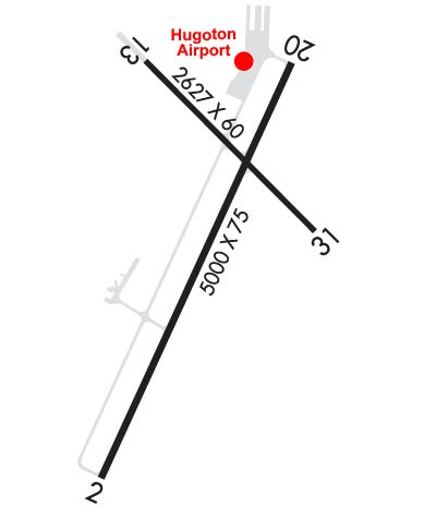
Runway Identifications
Runway Identification: 02/20Length: 5000 ft
Width: 75 ft
Surface: CONCRETE-FAIR CONDITION
Edge lights: High IntensityTreatment: NONE
Weight: PCN 11 /R/C/X/U
| | Runway: 02 | | Runway: 20 |
| Mag heading: | 20° | Mag heading: | 200° |
| Rwy Slope: | -.07% Down | Rwy Slope: | .07% Up |
| Approach: | | Approach: | |
| Pattern: | Left Traffic | Pattern: | Left Traffic |
| Markings: | NONPRECISION INSTRUMENT | Markings: | NONPRECISION INSTRUMENT |
| Marking Condition: | GOOD | Marking Condition: | GOOD |
| Arresting Dev: | | Arresting Dev: | |
| Lat & Long: | N3709.3 W10122.5 | Lat. & Long.: | N3710.1 W10122.0 |
| Elev: | 3133.4 ft. MSL | Elev: | 3129.7 ft. MSL |
| TCH: | 29 ft. AGL | TCH: | 29 ft. AGL |
| Visual Glide Path: | 3.00 degrees | Visual Glide Path: | 3.00 degrees |
| Displaced Threshold: | No | Displaced Threshold: | No |
| Touchdown Zone: | YES | Touchdown Zone: | YES |
| Touchdown Elev.: | 3133.6 feet | Touchdown Elev.: | 3131.7 feet |
| Visual Glide Slope: | 2-Light PAPI on LEFT side of Runway | Visual Glide Slope: | 2-Light PAPI on LEFT side of Runway |
| RVR Equipment: | | RVR Equipment: | |
| RVV Equipment: | NO | RVV Equipment: | NO |
| Approach Lights: | | Approach Lights: | |
| REIL: | NO | REIL: | NO |
| Centerline Lights: | NO | Centerline Lights: | NO |
| Touchdown lights: | NO | Touchdown lights: | NO |
| Runway Category: | Runway with a Non-precision Approach having visibility minimums greater than 3/4 mile | Runway Category: | Runway with a Non-precision Approach having visibility minimums greater than 3/4 mile |
| Declared Distances: | | Declared Distances: | |
| Obstructions: | ROAD | Obstructions: | ROAD |
| Marked: | NOT Marked/Lighted | Marked: | NOT Marked/Lighted |
| Clearance slope: | 32:1 | Clearance slope: | 26:1 |
| Obstruction height: | 17 feet AGL | Obstruction height: | 20 feet AGL |
| Dist. from runway: | 758 feet | Dist. from runway: | 731 feet |
| Centerline offset: | | Centerline offset: | |
| Comments: | | Comments: | |
Runway Identification: 13/31Length: 3039 ft
Width: 60 ft
Surface: ASPHALT-GOOD CONDITION
Edge lights: Treatment: NONE
Weight: PCN 5 /F/C/Y/U
| | Runway: 13 | | Runway: 31 |
| Mag heading: | 130° | Mag heading: | 310° |
| Rwy Slope: | -.06% Down | Rwy Slope: | .06% Up |
| Approach: | | Approach: | |
| Pattern: | Left Traffic | Pattern: | Left Traffic |
| Markings: | BASIC | Markings: | BASIC |
| Marking Condition: | GOOD | Marking Condition: | GOOD |
| Arresting Dev: | | Arresting Dev: | |
| Lat & Long: | N3710.1 W10122.4 | Lat. & Long.: | N3709.8 W10122.0 |
| Elev: | 3129.4 ft. MSL | Elev: | 3127.7 ft. MSL |
| TCH: | | TCH: | |
| Visual Glide Path: | | Visual Glide Path: | |
| Displaced Threshold: | 412 feet | Displaced Threshold: | 202 feet; DSPLCD THLD PAINTED. |
| Touchdown Zone: | YES | Touchdown Zone: | YES |
| Touchdown Elev.: | 3134.3 feet | Touchdown Elev.: | 3134.3 feet |
| Visual Glide Slope: | | Visual Glide Slope: | |
| RVR Equipment: | | RVR Equipment: | |
| RVV Equipment: | NO | RVV Equipment: | NO |
| Approach Lights: | | Approach Lights: | |
| REIL: | NO | REIL: | NO |
| Centerline Lights: | NO | Centerline Lights: | NO |
| Touchdown lights: | NO | Touchdown lights: | NO |
| Runway Category: | Runway with a Visual Approach | Runway Category: | Runway with a Visual Approach |
| Declared Distances: | | Declared Distances: | |
| Obstructions: | ROAD | Obstructions: | TOWER |
| Marked: | NOT Marked/Lighted | Marked: | NOT Marked/Lighted |
| Clearance slope: | 17:1 | Clearance slope: | 1:1 |
| Obstruction height: | 17 feet AGL | Obstruction height: | 12 feet AGL |
| Dist. from runway: | 503 feet | Dist. from runway: | 205 feet |
| Centerline offset: | | Centerline offset: | |
| Comments: | | Comments: | |