Current Weather/Notams (Metars, TAFs, Notams, NWS Forecast, PIREPS, and nearby weather)
Customs Information Send updates to Support@FltPlan.com
Customs Not Available
Database effective 04/18/2024
Airport Diagram might not be current.
|
| Facility Name: | BAYTOWN |
| City Name: | BAYTOWN |
| County: | HARRIS |
| State abbrev: | TX |
| State Name: | TEXAS |
| | |
| Ownership: | PRIVATELY OWNED |
| Use: | OPEN TO THE PUBLIC |
| Owner's Name: | RACECO INC--BAYTOWN ARPT |
| Address: | 5600 BARKALOO ROAD |
| | BAYTOWN, TX 77520 |
| Owner's Phone: | 281-421-1671 |
| | |
| Manager's Name: | CHARLES DANLEY |
| Address: | 5600 BARKALOO ROAD |
| | BAYTOWN, TX 77521 |
| Phone: | 713-303-8638; 713-303-8638 MGR CELL. |
| | |
| FAA Region: | SOUTHWEST |
| FAA Field Office: | TEX |
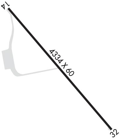
Runway Identifications
Runway Identification: 14/32Length: 4334 ft
Width: 60 ft
Surface: ASPHALT-GOOD CONDITION
Edge lights: Medium IntensityTreatment: NONE
| | Runway: 14 | | Runway: 32 |
| Mag heading: | 140° | Mag heading: | 320° |
| Rwy Slope: | -.15% Down | Rwy Slope: | .15% Up |
| Approach: | | Approach: | |
| Pattern: | Left Traffic | Pattern: | Left Traffic |
| Markings: | NONPRECISION INSTRUMENT | Markings: | NONPRECISION INSTRUMENT |
| Marking Condition: | GOOD | Marking Condition: | GOOD |
| Arresting Dev: | | Arresting Dev: | |
| Lat & Long: | N2947.4 W09457.4 | Lat. & Long.: | N2946.9 W09456.9 |
| Elev: | 33.8 ft. MSL | Elev: | 27.4 ft. MSL |
| TCH: | 20 ft. AGL | TCH: | 20 ft. AGL |
| Visual Glide Path: | 3.00 degrees | Visual Glide Path: | 3.00 degrees |
| Displaced Threshold: | 786 feet | Displaced Threshold: | 721 feet |
| Touchdown Zone: | YES | Touchdown Zone: | YES |
| Touchdown Elev.: | 33.8 feet | Touchdown Elev.: | 28.0 feet |
| Visual Glide Slope: | 2-Light PAPI on LEFT side of Runway | Visual Glide Slope: | 2-Light PAPI on LEFT side of Runway |
| RVR Equipment: | | RVR Equipment: | |
| RVV Equipment: | NO | RVV Equipment: | NO |
| Approach Lights: | | Approach Lights: | |
| REIL: | YES | REIL: | YES |
| Centerline Lights: | NO | Centerline Lights: | NO |
| Touchdown lights: | NO | Touchdown lights: | NO |
| Runway Category: | Runway with a Non-precision Approach having visibility minimums greater than 3/4 mile | Runway Category: | Runway with a Non-precision Approach having visibility minimums greater than 3/4 mile |
| Declared Distances: | TORA:4088' TODA:4088' ASDA:4088' LDA:3320' | Declared Distances: | TORA:4003' TODA:4003' ASDA:4003' LDA:3283' |
| Obstructions: | ROAD | Obstructions: | PLINE |
| Marked: | NOT Marked/Lighted | Marked: | MARKED |
| Clearance slope: | APCH SLOPE 11:1 TO DSPLCD THR OVR 76 FT TREES, 900 FT DSTC, 385 L. | Clearance slope: | APCH SLOPE 20:1 TO DSPLCD THR OVR 33 FT TREES, 463 FT DSTC, 260 FT L. |
| Obstruction height: | 15 feet AGL | Obstruction height: | 20 feet AGL |
| Dist. from runway: | 201 feet | Dist. from runway: | 200 feet |
| Centerline offset: | 131 left of centerline | Centerline offset: | |
| Comments: | +15 FT RD 65 FT FM THR 250 FT L EXTDD CNTRLN; 6 FT FENCE FM 120 FT FM THR ACRS EXTDD CNTRLN. | Comments: | 15 FT RD 0-199 FT DSTC FM 131 FT L - 185 FT R. |

