Current Weather/Notams (Metars, TAFs, Notams, NWS Forecast, PIREPS, and nearby weather)
Customs Information Send updates to Support@FltPlan.com
Customs Not Available
Database effective 05/16/2024
Airport Diagram might not be current.
|
| Facility Name: | MEML FLD |
| City Name: | HOT SPRINGS |
| County: | GARLAND |
| State abbrev: | AR |
| State Name: | ARKANSAS |
| | |
| Ownership: | PUBLICLY OWNED |
| Use: | OPEN TO THE PUBLIC |
| Owner's Name: | CITY OF HOT SPRINGS |
| Address: | PO BOX 700 |
| | HOT SPRINGS, AR 71902 |
| Owner's Phone: | 501-321-6810 |
| | |
| Manager's Name: | DON ROWLETT |
| Address: | 525 AIRPORT ROAD |
| | HOT SPRINGS, AR 71913 |
| Phone: | 501-321-6750 |
| | |
| FAA Region: | SOUTHWEST |
| FAA Field Office: | AOK |
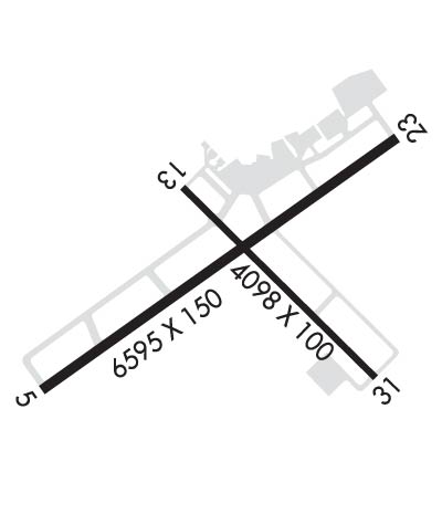
Runway Identifications
Runway Identification: 05/23Length: 6595 ft
Width: 150 ft
Surface: ASPHALT-GOOD CONDITION
Edge lights: High IntensityTreatment: GROOVED
Weight: PCN 54 /F/D/X/U
| | Runway: 05 | | Runway: 23 |
| Mag heading: | 53° | Mag heading: | 233° |
| Rwy Slope: | .59% Up | Rwy Slope: | -.59% Down |
| Approach: | ILS/DME | Approach: | |
| Pattern: | Right Traffic | Pattern: | Left Traffic |
| Markings: | PRECISION INSTRUMENT | Markings: | NONPRECISION INSTRUMENT |
| Marking Condition: | GOOD | Marking Condition: | GOOD |
| Arresting Dev: | | Arresting Dev: | |
| Lat & Long: | N3428.4 W09306.4 | Lat. & Long.: | N3429.0 W09305.3 |
| Elev: | 501.6 ft. MSL | Elev: | 540.3 ft. MSL |
| TCH: | | TCH: | 40 ft. AGL |
| Visual Glide Path: | | Visual Glide Path: | 3.00 degrees |
| Displaced Threshold: | No | Displaced Threshold: | No |
| Touchdown Zone: | YES | Touchdown Zone: | YES |
| Touchdown Elev.: | 515.7 feet | Touchdown Elev.: | 540.3 feet |
| Visual Glide Slope: | | Visual Glide Slope: | 4-Light PAPI on LEFT side of Runway; RWY 23 PAPI UNUSBL BYD 6 DEGS RIGHT OF CNTRLN. |
| RVR Equipment: | | RVR Equipment: | |
| RVV Equipment: | NO | RVV Equipment: | NO |
| Approach Lights: | MALSR - 1,400 foot medium intensity approach lighting system with runway alignment indicator lights | Approach Lights: | |
| REIL: | NO | REIL: | NO |
| Centerline Lights: | NO | Centerline Lights: | NO |
| Touchdown lights: | NO | Touchdown lights: | NO |
| Runway Category: | Precision Instrument Runway | Runway Category: | Runway with a Visual Approach |
| Declared Distances: | TORA:6595' TODA:6595' ASDA:6595' LDA:6595' | Declared Distances: | TORA:6595' TODA:6595' ASDA:6235' LDA:6235' |
| Obstructions: | | Obstructions: | POLE |
| Marked: | | Marked: | LIGHTED |
| Clearance slope: | 50:1 | Clearance slope: | 20:1 |
| Obstruction height: | | Obstruction height: | 78 feet AGL |
| Dist. from runway: | | Dist. from runway: | 1800 feet |
| Centerline offset: | | Centerline offset: | 650 feet right of centerline |
| Comments: | | Comments: | |
Runway Identification: 13/31Length: 4098 ft
Width: 100 ft
Surface: ASPHALT-GOOD CONDITION
Edge lights: Medium IntensityTreatment: NONE
Weight: PCN 25 /F/D/Y/T
| | Runway: 13 | | Runway: 31 |
| Mag heading: | 133° | Mag heading: | 313° |
| Rwy Slope: | -.35% Down | Rwy Slope: | .35% Up |
| Approach: | | Approach: | |
| Pattern: | Right Traffic | Pattern: | Left Traffic |
| Markings: | BASIC | Markings: | BASIC |
| Marking Condition: | GOOD | Marking Condition: | GOOD |
| Arresting Dev: | | Arresting Dev: | |
| Lat & Long: | N3428.9 W09306.0 | Lat. & Long.: | N3428.4 W09305.4 |
| Elev: | 519.8 ft. MSL | Elev: | 505.3 ft. MSL |
| TCH: | | TCH: | |
| Visual Glide Path: | | Visual Glide Path: | |
| Displaced Threshold: | No | Displaced Threshold: | No |
| Touchdown Zone: | YES | Touchdown Zone: | YES |
| Touchdown Elev.: | 519.8 feet | Touchdown Elev.: | 517.9 feet |
| Visual Glide Slope: | | Visual Glide Slope: | |
| RVR Equipment: | | RVR Equipment: | |
| RVV Equipment: | NO | RVV Equipment: | NO |
| Approach Lights: | | Approach Lights: | |
| REIL: | YES | REIL: | NO |
| Centerline Lights: | NO | Centerline Lights: | NO |
| Touchdown lights: | NO | Touchdown lights: | NO |
| Runway Category: | Runway with a Visual Approach | Runway Category: | Runway with a Visual Approach |
| Declared Distances: | TORA:3210' TODA:4098' ASDA:4098' LDA:4098' | Declared Distances: | TORA:4098' TODA:4098' ASDA:4098' LDA:3210' |
| Obstructions: | TREES | Obstructions: | POLE |
| Marked: | NOT Marked/Lighted | Marked: | LIGHTED |
| Clearance slope: | 10:1 | Clearance slope: | 24:1 |
| Obstruction height: | 40 feet AGL | Obstruction height: | 121 feet AGL |
| Dist. from runway: | 600 feet | Dist. from runway: | 3200 feet |
| Centerline offset: | 150 left of centerline | Centerline offset: | 300 feet right of centerline |
| Comments: | | Comments: | |

