Current Weather/Notams (Metars, TAFs, Notams, NWS Forecast, PIREPS, and nearby weather)
Customs Information Send updates to Support@FltPlan.com
Customs Not Available
Database effective 04/18/2024
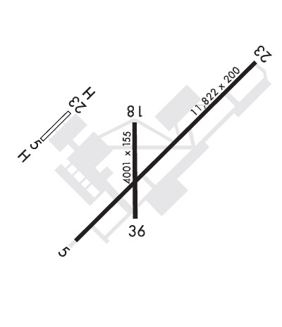
Airport Diagram might not be current. Facility Name: CAMPBELL AAF (FORT CAMPBELL) City Name: FORT CAMPBELL/HOPKINSVILLE County: CHRISTIAN State abbrev: KY State Name: KENTUCKY Ownership: ARMY OWNED Use: PRIVATE Owner's Name: US ARMY ATCA-ASO Address: 9325 GUNSTON ROAD FT BELVOIR, VA 22060 Owner's Phone: 502-798-7146 Manager's Name: AIRFIELD OPS Address: FORT CAMPBELL Phone: 270-798-7146/47 FAA Region: SOUTHERN FAA Field Office: MEM
Runway Identifications Help
Runway Identification: 05/23 Length: 10926 ftWidth: 150 ftSurface: ASPHALTEdge lights: High Intensity Treatment: NONEWeight: PCN 120/F/A/W/T Runway: 05 Runway: 23 Mag heading: N/A Mag heading: N/A Rwy Slope: .16% Up Rwy Slope: -.16% Down Approach: Approach: ILS/DME Pattern: Left Traffic Pattern: Right Traffic Markings: PRECISION INSTRUMENT Markings: PRECISION INSTRUMENT Marking Condition: GOOD Marking Condition: FAIR Arresting Dev: Arresting Dev: Lat & Long: N3639.8 W08730.2 Lat. & Long.: N3641.1 W08728.6 Elev: 553.8 ft. MSL Elev: 571.0 ft. MSL TCH: 59 ft. AGL TCH: 78 ft. AGL Visual Glide Path: 3.00 degrees Visual Glide Path: 3.00 degrees Displaced Threshold: No Displaced Threshold: No Touchdown Zone: YES Touchdown Zone: YES Touchdown Elev.: 555.1 feet Touchdown Elev.: 570.9 feet Visual Glide Slope: 4-Light PAPI on LEFT side of Runway Visual Glide Slope: 4-Light PAPI on LEFT side of Runway RVR Equipment: RVR Equipment: TOUCHDOWN RVV Equipment: NO RVV Equipment: NO Approach Lights: Approach Lights: SSALR - simplified short approach lighting system with runway alignment indicator lights REIL: NO REIL: NO Centerline Lights: NO Centerline Lights: NO Touchdown lights: NO Touchdown lights: NO Runway Category: Runway Category: Declared Distances: Declared Distances:
Runway Identification: 18/36 Length: 4500 ftWidth: 100 ftSurface: ASPHALTEdge lights: High Intensity Treatment: NONEWeight: PCN 37 /F/A/W/T Runway: 18 Runway: 36 Mag heading: N/A Mag heading: N/A Rwy Slope: -.17% Down Rwy Slope: .17% Up Approach: Approach: Pattern: Left Traffic Pattern: Left Traffic Markings: NONPRECISION INSTRUMENT Markings: BASIC Marking Condition: GOOD Marking Condition: POOR Arresting Dev: Arresting Dev: Lat & Long: N3640.6 W08729.8 Lat. & Long.: N3639.9 W08729.8 Elev: 561.4 ft. MSL Elev: 553.6 ft. MSL TCH: 50 ft. AGL TCH: 49 ft. AGL Visual Glide Path: 3.00 degrees Visual Glide Path: 3.00 degrees Displaced Threshold: No Displaced Threshold: No Touchdown Zone: YES Touchdown Zone: YES Touchdown Elev.: 562.4 feet Touchdown Elev.: 555.1 feet Visual Glide Slope: 4-Light PAPI on LEFT side of Runway Visual Glide Slope: 4-Light PAPI on LEFT side of Runway RVR Equipment: RVR Equipment: RVV Equipment: NO RVV Equipment: NO Approach Lights: Approach Lights: REIL: NO REIL: NO Centerline Lights: NO Centerline Lights: NO Touchdown lights: NO Touchdown lights: NO Runway Category: Runway Category: Declared Distances: Declared Distances: