Current Weather/Notams (Metars, TAFs, Notams, NWS Forecast, PIREPS, and nearby weather)
Customs Information Send updates to Support@FltPlan.com
Customs Not Available
Database effective 05/16/2024
Airport Diagram might not be current.
|
| Facility Name: | HURON RGNL |
| City Name: | HURON |
| County: | BEADLE |
| State abbrev: | SD |
| State Name: | SOUTH DAKOTA |
| | |
| Ownership: | PUBLICLY OWNED |
| Use: | OPEN TO THE PUBLIC |
| Owner's Name: | CITY OF HURON |
| Address: | PO BOX 1369 |
| | HURON, SD 57350 |
| Owner's Phone: | 605-353-8516 |
| | |
| Manager's Name: | LARRY COOPER |
| Address: | PO BOX 1369 |
| | HURON, SD 57350 |
| Phone: | 605-353-8516 |
| | |
| FAA Region: | GREAT LAKES |
| FAA Field Office: | DMA |
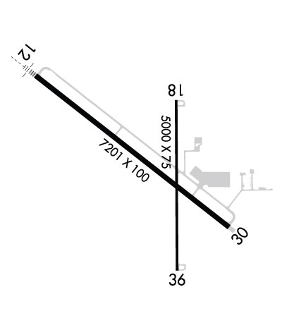
Runway Identifications
Runway Identification: 12/30Length: 7201 ft
Width: 100 ft
Surface: CONCRETE-GOOD CONDITION
Edge lights: High IntensityTreatment: GROOVED
Weight: PCN 51 /R/B/W/T
| | Runway: 12 | | Runway: 30 |
| Mag heading: | 121° | Mag heading: | 301° |
| Rwy Slope: | -.07% Down | Rwy Slope: | .07% Up |
| Approach: | ILS/DME | Approach: | |
| Pattern: | Left Traffic | Pattern: | Left Traffic |
| Markings: | PRECISION INSTRUMENT | Markings: | PRECISION INSTRUMENT |
| Marking Condition: | GOOD | Marking Condition: | GOOD |
| Arresting Dev: | | Arresting Dev: | |
| Lat & Long: | N4423.5 W09814.5 | Lat. & Long.: | N4422.8 W09813.2 |
| Elev: | 1288.7 ft. MSL | Elev: | 1283.3 ft. MSL |
| TCH: | 50 ft. AGL | TCH: | 50 ft. AGL |
| Visual Glide Path: | 3.00 degrees | Visual Glide Path: | 3.00 degrees |
| Displaced Threshold: | No | Displaced Threshold: | No |
| Touchdown Zone: | YES | Touchdown Zone: | YES |
| Touchdown Elev.: | 1288.7 feet | Touchdown Elev.: | 1285.7 feet |
| Visual Glide Slope: | 4-Light PAPI on LEFT side of Runway | Visual Glide Slope: | 4-Light PAPI on LEFT side of Runway |
| RVR Equipment: | | RVR Equipment: | |
| RVV Equipment: | NO | RVV Equipment: | NO |
| Approach Lights: | MALSR - 1,400 foot medium intensity approach lighting system with runway alignment indicator lights | Approach Lights: | |
| REIL: | NO | REIL: | YES |
| Centerline Lights: | NO | Centerline Lights: | NO |
| Touchdown lights: | NO | Touchdown lights: | NO |
| Runway Category: | Precision Instrument Runway | Runway Category: | Runway with a Non-precision Approach having visibility minimums greater than 3/4 mile |
| Declared Distances: | TORA:7201' TODA:7201' ASDA:7201' LDA:7201' | Declared Distances: | TORA:7201' TODA:7201' ASDA:7201' LDA:7201' |
| Obstructions: | | Obstructions: | ANT |
| Marked: | | Marked: | NOT Marked/Lighted |
| Clearance slope: | 50:1 | Clearance slope: | 28:1 |
| Obstruction height: | | Obstruction height: | 23 feet AGL |
| Dist. from runway: | | Dist. from runway: | 850 feet |
| Centerline offset: | | Centerline offset: | 500 feet right of centerline |
| Comments: | | Comments: | |
Runway Identification: 18/36Length: 5000 ft
Width: 75 ft
Surface: CONCRETE-GOOD CONDITION
Edge lights: Medium IntensityTreatment: NONE
Weight: PCN 11 /R/C/W/T
| | Runway: 18 | | Runway: 36 |
| Mag heading: | 173° | Mag heading: | 353° |
| Rwy Slope: | .03% Up | Rwy Slope: | -.03% Down |
| Approach: | | Approach: | |
| Pattern: | Left Traffic | Pattern: | Left Traffic |
| Markings: | NONPRECISION INSTRUMENT | Markings: | NONPRECISION INSTRUMENT |
| Marking Condition: | GOOD | Marking Condition: | GOOD |
| Arresting Dev: | | Arresting Dev: | |
| Lat & Long: | N4423.4 W09813.5 | Lat. & Long.: | N4422.6 W09813.5 |
| Elev: | 1283.2 ft. MSL | Elev: | 1284.9 ft. MSL |
| TCH: | 27 ft. AGL | TCH: | 25 ft. AGL |
| Visual Glide Path: | 3.00 degrees | Visual Glide Path: | 3.00 degrees |
| Displaced Threshold: | No | Displaced Threshold: | No |
| Touchdown Zone: | YES | Touchdown Zone: | YES |
| Touchdown Elev.: | 1288.1 feet | Touchdown Elev.: | 1288.4 feet |
| Visual Glide Slope: | 2-Light PAPI on LEFT side of Runway | Visual Glide Slope: | 2-Light PAPI on LEFT side of Runway |
| RVR Equipment: | | RVR Equipment: | |
| RVV Equipment: | NO | RVV Equipment: | NO |
| Approach Lights: | | Approach Lights: | |
| REIL: | YES | REIL: | YES |
| Centerline Lights: | NO | Centerline Lights: | NO |
| Touchdown lights: | NO | Touchdown lights: | NO |
| Runway Category: | Runway with a Visual Approach | Runway Category: | Runway with a Visual Approach |
| Declared Distances: | TORA:5000' TODA:5000' ASDA:5000' LDA:5000' | Declared Distances: | TORA:5000' TODA:5000' ASDA:5000' LDA:5000' |

