Current Weather/Notams (Metars, TAFs, Notams, NWS Forecast, PIREPS, and nearby weather)
Customs Information Send updates to Support@FltPlan.com
Customs Not Available
Database effective 05/16/2024

Airport Diagram might not be current.
|
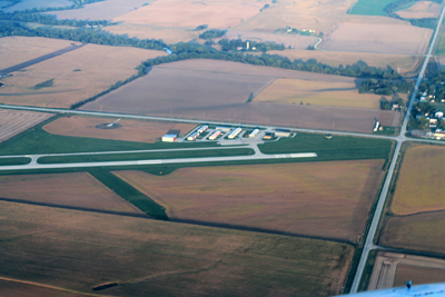
| Facility Name: | HARLAN MUNI |
| City Name: | HARLAN |
| County: | SHELBY |
| State abbrev: | IA |
| State Name: | IOWA |
| | |
| Ownership: | PUBLICLY OWNED |
| Use: | OPEN TO THE PUBLIC |
| Owner's Name: | CITY OF HARLAN |
| Address: | CITY HALL/BOX 650 |
| | HARLAN, IA 51537 |
| Owner's Phone: | 712-755-5137 |
| | |
| Manager's Name: | SCOTT PIGSLEY |
| Address: | 610 HWY 59 |
| | HARLAN, IA 51537 |
| Phone: | 712-744-3366 |
| | |
| FAA Region: | CENTRAL |
| FAA Field Office: | NONE |
Runway Identifications
Runway Identification: 03/21Length: 1712 ft
Width: 120 ft
Surface: GRASS-FAIR CONDITION
Edge lights: Treatment: NONE
Weight: PCN 7 /R/C/W/T
| | Runway: 03 | | Runway: 21 |
| Mag heading: | 35° | Mag heading: | 215° |
| Rwy Slope: | -.02% Down | Rwy Slope: | .02% Up |
| Approach: | | Approach: | |
| Pattern: | Left Traffic | Pattern: | Left Traffic |
| Markings: | | Markings: | |
| Marking Condition: | RY 03/21 THLDS & SIDES MARKED WITH CONES. | Marking Condition: | |
| Arresting Dev: | | Arresting Dev: | |
| Lat & Long: | N4134.9 W09520.5 | Lat. & Long.: | N4135.1 W09520.2 |
| Elev: | 1194.1 ft. MSL | Elev: | 1193.8 ft. MSL |
| TCH: | | TCH: | |
| Visual Glide Path: | | Visual Glide Path: | |
| Displaced Threshold: | No | Displaced Threshold: | No |
| Touchdown Zone: | YES | Touchdown Zone: | YES |
| Touchdown Elev.: | 1198.8 feet | Touchdown Elev.: | 1198.8 feet |
| Visual Glide Slope: | | Visual Glide Slope: | |
| RVR Equipment: | | RVR Equipment: | |
| RVV Equipment: | NO | RVV Equipment: | NO |
| Approach Lights: | | Approach Lights: | |
| REIL: | NO | REIL: | NO |
| Centerline Lights: | NO | Centerline Lights: | NO |
| Touchdown lights: | NO | Touchdown lights: | NO |
| Runway Category: | Runway with a Visual Approach | Runway Category: | Runway with a Visual Approach |
| Declared Distances: | | Declared Distances: | |
| Obstructions: | FENCE | Obstructions: | FENCE |
| Marked: | NOT Marked/Lighted | Marked: | NOT Marked/Lighted |
| Clearance slope: | 25:1 | Clearance slope: | 29:1 |
| Obstruction height: | 8 feet AGL | Obstruction height: | 10 feet AGL |
| Dist. from runway: | 200 feet | Dist. from runway: | 295 feet |
| Centerline offset: | | Centerline offset: | |
| Comments: | | Comments: | |
Runway Identification: 15/33Length: 4100 ft
Width: 75 ft
Surface: CONCRETE-GOOD CONDITION
Edge lights: Medium IntensityTreatment: NONE
| | Runway: 15 | | Runway: 33 |
| Mag heading: | 150° | Mag heading: | 330° |
| Rwy Slope: | -.90% Down | Rwy Slope: | .90% Up |
| Approach: | | Approach: | |
| Pattern: | Left Traffic | Pattern: | Left Traffic |
| Markings: | NONPRECISION INSTRUMENT | Markings: | NONPRECISION INSTRUMENT |
| Marking Condition: | GOOD | Marking Condition: | GOOD |
| Arresting Dev: | | Arresting Dev: | |
| Lat & Long: | N4135.4 W09520.6 | Lat. & Long.: | N4134.8 W09520.2 |
| Elev: | 1231.0 ft. MSL | Elev: | 1194.3 ft. MSL |
| TCH: | 40 ft. AGL | TCH: | 40 ft. AGL |
| Visual Glide Path: | 3.00 degrees | Visual Glide Path: | 3.00 degrees |
| Displaced Threshold: | No | Displaced Threshold: | No |
| Touchdown Zone: | YES | Touchdown Zone: | YES |
| Touchdown Elev.: | 1231.0 feet | Touchdown Elev.: | 1212.8 feet |
| Visual Glide Slope: | 2-Light PAPI on LEFT side of Runway | Visual Glide Slope: | 2-Light PAPI on LEFT side of Runway |
| RVR Equipment: | | RVR Equipment: | |
| RVV Equipment: | NO | RVV Equipment: | NO |
| Approach Lights: | | Approach Lights: | |
| REIL: | YES | REIL: | YES |
| Centerline Lights: | NO | Centerline Lights: | NO |
| Touchdown lights: | NO | Touchdown lights: | NO |
| Runway Category: | Runway with a Non-precision Approach | Runway Category: | Runway with a Non-precision Approach |
| Declared Distances: | | Declared Distances: | |
| Obstructions: | GND | Obstructions: | ROAD |
| Marked: | NOT Marked/Lighted | Marked: | NOT Marked/Lighted |
| Clearance slope: | 20:1 | Clearance slope: | 20:1 |
| Obstruction height: | 14 feet AGL | Obstruction height: | 16 feet AGL |
| Dist. from runway: | 490 feet | Dist. from runway: | 528 feet |
| Centerline offset: | 200 left of centerline | Centerline offset: | |
| Comments: | | Comments: | |