KHND

Whisper PlateWhisper Track
HENDERSON EXECUTIVE
LAS VEGAS
NV
Time Zone: Pacific
Lat: N 3558.4
Long: W 11508.1
Elev: 2491
Var: -13
Longest Runway: 6501
Clr Del: 135.35/125.9
Dept. ATIS: 120.77
Arr. ATIS: 120.77
Ground: 127.8
Tower: 125.1

FBO & Flight Services info for KHND

FBOs: Update your Fuel Prices
At Henderson Executive Airport, FBO services include: NATA Safety First trained line service, competitive rates, baggage handling, after-hours security, aviation charts, ground power unit, lavatory service, oxygen service, nitrogen (tires only), aircraft oil, and potable water.
Ph: 702-261-4800 Fax: 702-261-4820 Freq: 131.57Website-
                     
Service
Jet
100LL
SAF
MoGas
Fuel Avail: Call Out Fee before 0530 or after 2200
Full7.176.89    Last Update: 04/17/2024 11:40

Self  6.59    
Misc. Info: Tiered discounts on Jet beginning at 125 gallons.Address: 3500 EXECUTIVE TERMINAL DRIVE, SUITE 100,   HENDERSON, NV 89052

APEX AVIATIONPh: 702-735-2739
-
-
Service
Jet
100LL
SAF
MoGas
Fuel Avail: ~~NO FUEL. Service & Repairs Only. M-F 0800-1700, On-Call Weekends 0800-1700
Full        Last Update: 04/18/2024 05:44:57  
Self        
 Address: 1410 JET STREAM DRIVE, SUITE 100,   HENDERSON, NV 89052
If you are an FBO, call 1-203-262-1700 to update your info or email: FltPlan.Advertising@garmin.com
Advertise your FBO on FltPlan.com

Runway & Approach Info for KHND
Rwy
Length
Land Dist**
Approach*
  Rwy
Length
Land Dist**
Approach*
17L
5001x75  5001'          
 
  
35R
  5001x75  5001'          
 
17R
6501x100  6501'          
 
  
35L
  6501x100  6501'          
 
 * only ILS, LOC, LDA, and SDF approaches to a specific runway are shown
** For any Declared Landing Distance Available, please see A/FD or Approach plates
Runway Weight Capability (lbs.) Help
Runway IDSingle WheelDouble WheelDouble Tandem WheelDual Double Wheel
17L/35R30,00030,000N/AN/A
17R/35L30,00060,000N/AN/A
These numbers are Advisory and are not limits.   The Airport Manager should have more accurate Weight Limits
Approach Charts
Approaches    
Current Weather/Notams
Customs Information Send updates to Support@FltPlan.com
Customs Not Available
Database effective 04/18/2024
Airport Diagram of KHND
Airport Diagram might not be current.

Facility Name: HENDERSON EXEC
City Name: LAS VEGAS
County: CLARK
State abbrev: NV
State Name: NEVADA
   
Ownership: PUBLICLY OWNED
Use: OPEN TO THE PUBLIC
Owner's Name: CLARK COUNTY
Address: 3500 EXECUTIVE TERMINAL DR., SUITE 100
 HENDERSON, NV 89052
Owner's Phone: 702-261-4800
  
Manager's Name: BRUCE DAUGHERTY; OPS: 702-261-4851.
Address: 3500 EXECUTIVE TERMINAL DRIVE, SUITE 100
 HENDERSON, NV 89052
Phone: 702-261-4802
   
FAA Region: WESTERN-PACIFIC
FAA Field Office: PHX


Sunrise / Sunset times for HENDERSON EXEC

DateSunriseSunset
04/17/24 Wednesday6:0419:17
04/18/24 Thursday6:0319:17
04/19/24 Friday6:0119:18
04/20/24 Saturday6:0019:19
04/21/24 Sunday5:5919:20
04/22/24 Monday5:5719:21
04/23/24 Tuesday5:5619:22
04/24/24 Wednesday5:5519:23
04/25/24 Thursday5:5419:23
04/26/24 Friday5:5319:24
04/27/24 Saturday5:5219:25
04/28/24 Sunday5:5019:26
04/29/24 Monday5:4919:27
04/30/24 Tuesday5:4819:28

Airport Facilities

Airport Attendance Schedule7 Days A Week 0500-2230
Airport Status OPERATIONAL (This Status can change at any time - please check NOTAMS)
Airport Lighting ScheduleACTVT REIL RWY 17R & 35L, 17L & 35R; PAPI RWY 17R & 35L, 17L & 35R; MIRL RWY 17R/35L, 17L/35R - CTAF.
Airport Storage AvailableTie Downs
Extra Services AvailableAir Ambulance, Avionics, Charter, Flight Instruction, Aircraft Rental, Aircraft Sales
Wind IndicatorYES - (lighted)
Control TowerYES
CTAF Frequency125.100
Unicom Frequency122.950
Rotating Beacon ColorWG
Segmented CircleYES
Landing FeeNO

Airport Inspection Data

Airport InspectedSTATE - performed by STATE AERONAUTICAL PERSONNEL
Inspection Date06/07/2022

Airport Services

Type of Fuel AvailableGrade 100LL, JET A (freeze point -40C); -10100LL SELF-SVC H24.
Airframe Repair ServiceMINOR
Power Plant Repair ServiceMINOR

Geographic Data

LatitudeN3558.4
LongitudeW11508.1 (ESTIMATED)
Arpt Elevation2491ft (SURVEYED)
Magnetic Variation13E
11 miles Sof LAS VEGAS
Traffic Pattern Altitude
Sectional ChartLAS VEGAS

Aircraft Data

Operations (Reported)YearlyAvg. Daily
General Aviation Transient 39600108
General Aviation Local 2180060
Air Taxi 1640045
Commerical 00
Commuter 00
Military 2001
Aircraft based on Field
General Aviation Singles 213
General Aviation Multi 17
Jet Aircraft 37
General Aviation Helicopters 3
Military Aircraft 0
Gliders 0
Ultralights 0

FAA Services

FSS on field NO
FSS tie-in RENO
FSS Phone 1-800-WX-BRIEF
Who issues Notams HND
Notam D service at airport YES
ARTCC Name LOS ANGELES

Federal Status

Airport Certification
Aircraft Rescue & Firefighting IndexNone
Airport of EntryNo
Custom Landing RightsNo
Joint Civil/MilitaryNo
Military Landing rightsNo

Federal Agreements

NATIONAL PLAN OF INTEGRATED AIRPORT SYSTEMS (NPIAS)
GRANT AGREEMENTS UNDER FAAP/ADAP/AIP
ASSURANCES PURSUANT TO TITLE VI, CIVIL RIGHTS ACT OF 1964

Remarks

COML AIR TOUR TFC ARR FM SE DALGT HR.
CTN: ACFT DEP RWY 17R OR 35L MUST VFY PSN ON RWY NOT ON PARL TWY.
FOR CD WHEN ATCT CLSD CTC LAS APCH ON 125.475 OR PH 725-200-4432.
WHEN SPL EVENT PRKG PPR PROGRAM NOTAM IS ACTV, TSNT ACFT OPERS NOT PERM BASED NEED TO OBTAIN A PPR NR FM AN FBO FOR EA LDG. PPR APPVL & CONFIRMATION NRS CAN BE OBTAINED FM THE SEL FBO AT 702-261-7775. PPR CONFIRMATION NRS SHOULD BE ENTERED IN THE
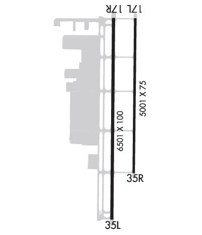
RWY 17L/ 35ROPS DLY 1900-0700.
Airport Communications & Frequencies:
ATIS Frequencies:   Hours(local) of Operation: CONTINUOUS
120.775
HENDERSON Tower Frequencies:   Hours(local) of operation: 0600-2000   
125.1
HENDERSON Ground Frequencies:
127.8
Clearance Delivery Frequencies:
135.35
125.475 WHEN TWR CLSD
CTAF Frequency:
125.100
Unicom Frequency:
122.950
Remarks
  • ATCT OPER BY MIDWEST ATC INC.
  • COMMUNICATIONS PRVDD BY RENO RADIO ON FREQ 122.6 (MOUNT POTOSI RCO).
  • LAS VEGAS Primary Approach Frequencies:  
    125.475
    307.25
    LAS VEGAS Primary Departure Frequencies:  
    125.475
    307.25
    Runway Identifications
    Runway Identification: 17L/35R
    Length: 5001 ft
    Width: 75 ft
    Surface: ASPHALT
    Edge lights: Medium Intensity

    Treatment: NONE

     Runway: 17L   Runway: 35R
    Mag heading: 168°Mag heading: 348°
    Rwy Slope: 1.38% UpRwy Slope: -1.38% Down
    Approach: Approach:
    Pattern: Left TrafficPattern: Left Traffic
    Markings: NONPRECISION INSTRUMENTMarkings: NONPRECISION INSTRUMENT
    Marking Condition: GOODMarking Condition: GOOD
    Arresting Dev: Arresting Dev:
    Lat & Long: N3558.9  W11508.0Lat. & Long.: N3558.0  W11508.0
    Elev: 2405.9 ft. MSLElev: 2474.9 ft. MSL
    TCH: 40 ft. AGLTCH: 52 ft. AGL
    Visual Glide Path: 3.00 degreesVisual Glide Path: 4.30 degrees
    Displaced Threshold: NoDisplaced Threshold: No
    Touchdown Zone: YESTouchdown Zone: YES
    Touchdown Elev.: 2444.9 feetTouchdown Elev.: 2474.9 feet
    Visual Glide Slope: 4-Light PAPI on LEFT side of RunwayVisual Glide Slope: 4-Light PAPI on LEFT side of Runway; PAPI UNUSBL BYD 3.5 NM FM RWY THR.
    RVR Equipment: RVR Equipment:
    RVV Equipment: NORVV Equipment: NO
    Approach Lights: Approach Lights:
    REIL: YESREIL: YES
    Centerline Lights: NOCenterline Lights: NO
    Touchdown lights: NOTouchdown lights: NO
    Runway Category: Runway with a Visual ApproachRunway Category: Runway with a Visual Approach
    Declared Distances: Declared Distances:
    Runway Identification: 17R/35L
    Length: 6501 ft
    Width: 100 ft
    Surface: ASPHALT
    Edge lights: Medium Intensity

    Treatment: NONE

     Runway: 17R   Runway: 35L
    Mag heading: 168°Mag heading: 348°
    Rwy Slope: 1.38% UpRwy Slope: -1.38% Down
    Approach: Approach:
    Pattern: Left TrafficPattern: Left Traffic
    Markings: NONPRECISION INSTRUMENTMarkings: NONPRECISION INSTRUMENT
    Marking Condition: GOODMarking Condition: GOOD
    Arresting Dev: Arresting Dev:
    Lat & Long: N3558.9  W11508.1Lat. & Long.: N3557.8  W11508.1
    Elev: 2401.8 ft. MSLElev: 2491.4 ft. MSL
    TCH: 40 ft. AGLTCH: 52 ft. AGL
    Visual Glide Path: 3.00 degreesVisual Glide Path: 4.30 degrees
    Displaced Threshold: NoDisplaced Threshold: No
    Touchdown Zone: YESTouchdown Zone: YES
    Touchdown Elev.: 2438.8 feetTouchdown Elev.: 2491.4 feet
    Visual Glide Slope: 4-Light PAPI on LEFT side of RunwayVisual Glide Slope: 4-Light PAPI on LEFT side of Runway; PAPI UNUSBL BYD 3.3 NM FM RWY THR.
    RVR Equipment: RVR Equipment:
    RVV Equipment: NORVV Equipment: NO
    Approach Lights: Approach Lights:
    REIL: YESREIL: YES
    Centerline Lights: NOCenterline Lights: NO
    Touchdown lights: NOTouchdown lights: NO
    Runway Category: Runway with a Visual ApproachRunway Category: Runway with a Visual Approach
    Declared Distances: Declared Distances:
    Obstructions: Obstructions: ROAD
    Marked: Marked: NOT Marked/Lighted
    Clearance slope: 50:1Clearance slope: 20:1
    Obstruction height: Obstruction height: 44 feet AGL
    Dist. from runway: Dist. from runway: 1095 feet
    Centerline offset: Centerline offset:
    Comments: Comments:
    C:198/P: