
| ||||||||||||||||||||||||||||||||||||||||||||
| ||||||||||||||||||||||||||||||||||||||||||||
| ||||||||||||||||||||||||||||||||||||||||||||
| Rwy | Rwy | |||||||
| 5501x100 | 5501' | 5501x100 | 5501' | |||||
| Runway ID | Single Wheel | Double Wheel | Double Tandem Wheel | Dual Double Wheel |
| 09/27 | 29,000 | 50,000 | N/A | N/A |
| These numbers are Advisory and are not limits. The Airport Manager should have more accurate Weight Limits | ||||
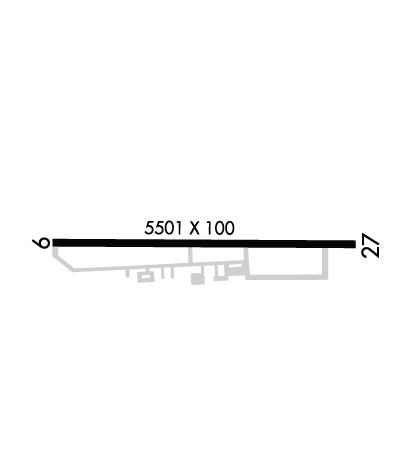 Airport Diagram might not be current. | |
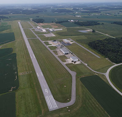
| Facility Name: | HUNTINGBURG |
| City Name: | HUNTINGBURG |
| County: | DUBOIS |
| State abbrev: | IN |
| State Name: | INDIANA |
| Ownership: | PUBLICLY OWNED |
| Use: | OPEN TO THE PUBLIC |
| Owner's Name: | DUBOIS COUNTY ARPT AUTH |
| Address: | P.O. BOX 293 |
| HUNTINGBURG, IN 47542 | |
| Owner's Phone: | 812-683-5454 |
| Manager's Name: | TRAVIS MCQUEEN |
| Address: | 2495 WEST 900 SOUTH, PO BOX 293 |
| HUNTINGBURG, IN 47542 | |
| Phone: | 812-683-5454 |
| FAA Region: | GREAT LAKES |
| FAA Field Office: | CHI |
| Date | Sunrise | Sunset |
|---|---|---|
| 04/23/24 Tuesday | 7:00 | 20:32 |
| 04/24/24 Wednesday | 6:59 | 20:33 |
| 04/25/24 Thursday | 6:58 | 20:34 |
| 04/26/24 Friday | 6:56 | 20:35 |
| 04/27/24 Saturday | 6:55 | 20:36 |
| 04/28/24 Sunday | 6:54 | 20:37 |
| 04/29/24 Monday | 6:53 | 20:38 |
| 04/30/24 Tuesday | 6:51 | 20:39 |
| 05/01/24 Wednesday | 6:50 | 20:40 |
| 05/02/24 Thursday | 6:49 | 20:41 |
| 05/03/24 Friday | 6:48 | 20:42 |
| 05/04/24 Saturday | 6:47 | 20:43 |
| 05/05/24 Sunday | 6:46 | 20:44 |
| 05/06/24 Monday | 6:45 | 20:45 |
| Airport Attendance Schedule | MON-FRI 0700-1600; AFT HR & WKEND PPR - AMGR. |
| Airport Status | OPERATIONAL (This Status can change at any time - please check NOTAMS) |
| Airport Lighting Schedule | ACTVT REIL RWY 09 & 27; PAPI RWY 09 & 27; MIRL RWY 09/27 - CTAF.; SS-SR; ACTVT ROTG BCN SR-SS CTAF. |
| Airport Storage Available | Tie Downs, Hanger |
| Extra Services Available | Crop Dusting, Flight Instruction, Aircraft Rental |
| Wind Indicator | YES - (lighted) |
| Control Tower | NO |
| CTAF Frequency | 122.800 |
| Unicom Frequency | 122.800 |
| Rotating Beacon Color | WG |
| Segmented Circle | NO |
| Landing Fee | NO |
| Airport Inspected | STATE - performed by STATE AERONAUTICAL PERSONNEL |
| Inspection Date | 05/11/2023 |
| Type of Fuel Available | Grade 100LL, JET A-1 (icing inhibitor, freeze point -50C) |
| Airframe Repair Service | MINOR |
| Power Plant Repair Service | MINOR |
| Latitude | N3814.9 |
| Longitude | W08657.2 (ESTIMATED) |
| Arpt Elevation | 529ft (SURVEYED) |
| Magnetic Variation | 04W |
| 3 miles S | of HUNTINGBURG |
| Traffic Pattern Altitude | |
| Sectional Chart | ST LOUIS |
| Operations (Reported) | Yearly | Avg. Daily |
|---|---|---|
| General Aviation Transient | 1018 | 3 |
| General Aviation Local | 5907 | 16 |
| Air Taxi | 291 | 1 |
| Commerical | 0 | 0 |
| Commuter | 0 | 0 |
| Military | 75 | 0 |
| Aircraft based on Field | |
|---|---|
| General Aviation Singles | 17 |
| General Aviation Multi | 9 |
| Jet Aircraft | 2 |
| General Aviation Helicopters | 1 |
| Military Aircraft | 0 |
| Gliders | 2 |
| Ultralights | 0 |
| FSS on field | NO |
| FSS tie-in | TERRE HAUTE |
| FSS Phone | 1-800-WX-BRIEF |
| Who issues Notams | HNB |
| Notam D service at airport | YES |
| ARTCC Name | INDIANAPOLIS |
| Airport Certification | |
| Aircraft Rescue & Firefighting Index | None |
| Airport of Entry | No |
| Custom Landing Rights | No |
| Joint Civil/Military | No |
| Military Landing rights | YES |
| NATIONAL PLAN OF INTEGRATED AIRPORT SYSTEMS (NPIAS) |
| GRANT AGREEMENTS UNDER FAAP/ADAP/AIP |
| ASSURANCES PURSUANT TO TITLE VI, CIVIL RIGHTS ACT OF 1964 |
| TWY EDGE MRKD BY BLUE REFLECTORS. |
| FOR CD WHEN RCO 118.8 OTS CTC EVANSVILLE APCH AT 812-436-4689, WHEN APCH CLSD CTC INDIANAPOLIS ARTCC AT 317-247-2411. |
| SELF SVC FUEL AVBL WITH CREDIT CARD. |
Airport Communications & Frequencies:
| |||||||||||||||||||
| Runway: 09 | Runway: 27 | ||
| Mag heading: | 95° | Mag heading: | 275° |
| Rwy Slope: | .29% Up | Rwy Slope: | -.29% Down |
| Approach: | Approach: | ||
| Pattern: | Left Traffic | Pattern: | Left Traffic |
| Markings: | PRECISION INSTRUMENT | Markings: | PRECISION INSTRUMENT |
| Marking Condition: | GOOD | Marking Condition: | GOOD |
| Arresting Dev: | Arresting Dev: | ||
| Lat & Long: | N3814.9 W08657.7 | Lat. & Long.: | N3814.9 W08656.6 |
| Elev: | 513.1 ft. MSL | Elev: | 529.0 ft. MSL |
| TCH: | 40 ft. AGL | TCH: | 42 ft. AGL |
| Visual Glide Path: | 3.00 degrees | Visual Glide Path: | 3.00 degrees |
| Displaced Threshold: | No | Displaced Threshold: | No |
| Touchdown Zone: | YES | Touchdown Zone: | YES |
| Touchdown Elev.: | 524.4 feet | Touchdown Elev.: | 529.1 feet |
| Visual Glide Slope: | 4-Light PAPI on LEFT side of Runway; PAPI UNUSBL BYD 5 DEG LEFT OF CNTRLN. | Visual Glide Slope: | 4-Light PAPI on LEFT side of Runway |
| RVR Equipment: | RVR Equipment: | ||
| RVV Equipment: | NO | RVV Equipment: | NO |
| Approach Lights: | Approach Lights: | ||
| REIL: | YES | REIL: | YES |
| Centerline Lights: | NO | Centerline Lights: | NO |
| Touchdown lights: | NO | Touchdown lights: | NO |
| Runway Category: | Runway with a Non-precision Approach having visibility minimums greater than 3/4 mile | Runway Category: | Runway with a Non-precision Approach having visibility minimums greater than 3/4 mile |
| Declared Distances: | Declared Distances: | ||
| Obstructions: | ROAD | Obstructions: | |
| Marked: | NOT Marked/Lighted | Marked: | |
| Clearance slope: | 31:1 | Clearance slope: | 34:1 |
| Obstruction height: | 6 feet AGL | Obstruction height: | |
| Dist. from runway: | 390 feet | Dist. from runway: | |
| Centerline offset: | 280 left of centerline | Centerline offset: | |
| Comments: | Comments: |