
| |||||
|
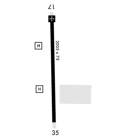
| Rwy | Rwy | |||||||
| 2005x75 | 2005' | 2005x75 | 2005' | |||||
| Runway ID | Single Wheel | Double Wheel | Double Tandem Wheel | Dual Double Wheel |
| 17/35 | N/A | N/A | N/A | N/A |
| H1 | N/A | N/A | N/A | N/A |
| H2 | N/A | N/A | N/A | N/A |
| These numbers are Advisory and are not limits. The Airport Manager should have more accurate Weight Limits | ||||
 Airport Diagram might not be current. | |
| Facility Name: | MULDROW AHP |
| City Name: | LEXINGTON |
| County: | CLEVELAND |
| State abbrev: | OK |
| State Name: | OKLAHOMA |
| Ownership: | ARMY OWNED |
| Use: | PRIVATE |
| Owner's Name: | OKLAHOMA ARMY NATIONAL GUARD |
| Address: | HIGHWAY 39E & 144TH AVE |
| LEXINGTON, OK 73051 | |
| Owner's Phone: | 405-217-8101 |
| Manager's Name: | CYRUS HAINES |
| Address: | HIGHWAY 39E & 144TH AVE |
| LEXINGTON, OK 73051 | |
| Phone: | 405-217-8190; 405-217-8191. |
| FAA Region: | SOUTHWEST |
| FAA Field Office: | AOK |
| Date | Sunrise | Sunset |
|---|---|---|
| 04/23/24 Tuesday | 6:46 | 20:09 |
| 04/24/24 Wednesday | 6:45 | 20:09 |
| 04/25/24 Thursday | 6:44 | 20:10 |
| 04/26/24 Friday | 6:43 | 20:11 |
| 04/27/24 Saturday | 6:42 | 20:12 |
| 04/28/24 Sunday | 6:40 | 20:13 |
| 04/29/24 Monday | 6:39 | 20:13 |
| 04/30/24 Tuesday | 6:38 | 20:14 |
| 05/01/24 Wednesday | 6:37 | 20:15 |
| 05/02/24 Thursday | 6:36 | 20:16 |
| 05/03/24 Friday | 6:35 | 20:17 |
| 05/04/24 Saturday | 6:34 | 20:18 |
| 05/05/24 Sunday | 6:33 | 20:18 |
| 05/06/24 Monday | 6:32 | 20:19 |
| Airport Attendance Schedule | SEE REMARKS; TUES - THURS 1130-0500Z++; MON & FRI 1130-2230Z++; SLCT WKENDS 1300-2200Z++; OTR TIMES - C405-595-8844. |
| Airport Status | OPERATIONAL (This Status can change at any time - please check NOTAMS) |
| Airport Lighting Schedule | ACTVT LIRL RWY 17/35; PERIMETER LGTS H1 & H2; TWY LGTS - C405-217-8100.; ROTG BCN - C405-217-8100. |
| Airport Storage Available | NONE |
| Extra Services Available | NONE |
| Wind Indicator | YES - (unlit) |
| Control Tower | NO |
| CTAF Frequency | |
| Unicom Frequency | |
| Rotating Beacon Color | WGY |
| Segmented Circle | NO |
| Landing Fee |
| Airport Inspected | 5010-2 PRIVATE USE MAILOUT PROGRAM - performed by the OWNER |
| Inspection Date | Unknown |
| Type of Fuel Available | ++ |
| Airframe Repair Service | None |
| Power Plant Repair Service | None |
| Latitude | N3501.6 |
| Longitude | W09713.9 (ESTIMATED) |
| Arpt Elevation | 1091ft (SURVEYED) |
| Magnetic Variation | 06E |
| 4 miles E | of LEXINGTON |
| Traffic Pattern Altitude | |
| Sectional Chart | DALLAS-FT WORTH |
| Operations (Reported) | Yearly | Avg. Daily |
|---|---|---|
| General Aviation Transient | 0 | 0 |
| General Aviation Local | 0 | 0 |
| Air Taxi | 0 | 0 |
| Commerical | 0 | 0 |
| Commuter | 0 | 0 |
| Military | 0 | 0 |
| Aircraft based on Field | |
|---|---|
| General Aviation Singles | 0 |
| General Aviation Multi | 0 |
| Jet Aircraft | 0 |
| General Aviation Helicopters | 0 |
| Military Aircraft | 16 |
| Gliders | 0 |
| Ultralights | 0 |
| FSS on field | NO |
| FSS tie-in | MC ALESTER |
| FSS Phone | 1-800-WX-BRIEF |
| Who issues Notams | MLC |
| Notam D service at airport | YES |
| ARTCC Name | FORT WORTH |
| Airport Certification | |
| Aircraft Rescue & Firefighting Index | None |
| Airport of Entry | No |
| Custom Landing Rights | No |
| Joint Civil/Military | No |
| Military Landing rights | No |
| CTN: HEL PRKG RAMP HAS PERIMETER FENCE. |
| RSTD: PPR FOR TSNT FUEL, PRK & NGT OPS - D628-8101/C405-217-8101. |
| SERVICE: FLUID - SP OIL. |
| SERVICE: JASU - 1, AGPU F. |
| FOR CD CTC OKC CITY APCH AT 405-681-5683. |
| RWY H1 DSGND NORTHPAD. |
| RWY H2 DSGND SOUTHPAD. |
Airport Communications & Frequencies:
| |||||||||||||
| Runway: 17 | Runway: 35 | ||
| Mag heading: | N/A | Mag heading: | N/A |
| Rwy Slope: | -.11% Down | Rwy Slope: | .11% Up |
| Approach: | Approach: | ||
| Pattern: | Left Traffic | Pattern: | Left Traffic |
| Markings: | BASIC | Markings: | BASIC |
| Marking Condition: | FAIR | Marking Condition: | FAIR |
| Arresting Dev: | Arresting Dev: | ||
| Lat & Long: | N3501.7 W09713.9 | Lat. & Long.: | N3501.4 W09713.9 |
| Elev: | 1091.3 ft. MSL | Elev: | 1089.0 ft. MSL |
| TCH: | TCH: | ||
| Visual Glide Path: | Visual Glide Path: | ||
| Displaced Threshold: | No | Displaced Threshold: | No |
| Touchdown Zone: | YES | Touchdown Zone: | YES |
| Touchdown Elev.: | 1091.3 feet | Touchdown Elev.: | 1091.3 feet |
| Visual Glide Slope: | Visual Glide Slope: | ||
| RVR Equipment: | RVR Equipment: | ||
| RVV Equipment: | NO | RVV Equipment: | NO |
| Approach Lights: | Approach Lights: | ||
| REIL: | NO | REIL: | NO |
| Centerline Lights: | NO | Centerline Lights: | NO |
| Touchdown lights: | NO | Touchdown lights: | NO |
| Runway Category: | Runway Category: | ||
| Declared Distances: | Declared Distances: | ||
| Obstructions: | ROAD | Obstructions: | ROAD |
| Marked: | NOT Marked/Lighted | Marked: | NOT Marked/Lighted |
| Clearance slope: | Clearance slope: | ||
| Obstruction height: | 15 feet AGL | Obstruction height: | 15 feet AGL |
| Dist. from runway: | 100 feet | Dist. from runway: | 420 feet |
| Centerline offset: | Centerline offset: | ||
| Comments: | Comments: |
