
| ||||||||||||||||||||||||||||||||||||||||||||
| ||||||||||||||||||||||||||||||||||||||||||||
| ||||||||||||||||||||||||||||||||||||||||||||
| ||||||||||||||||||||||||||||||||||||||||||||
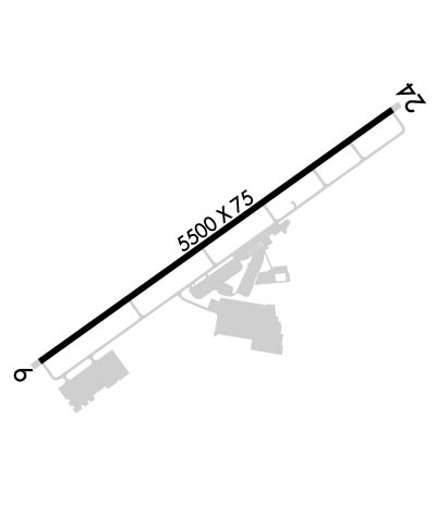
| Rwy | Rwy | |||||||
| 5509x100 | 5509' | 5509x100 | 5509' | |||||
| Runway ID | Single Wheel | Double Wheel | Double Tandem Wheel | Dual Double Wheel |
| 06/24 | 30,000 | 45,000 | N/A | N/A |
| These numbers are Advisory and are not limits. The Airport Manager should have more accurate Weight Limits | ||||
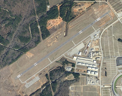
 Airport Diagram might not be current. | |
| Facility Name: | ATLANTA SPEEDWAY |
| City Name: | ATLANTA |
| County: | HENRY |
| State abbrev: | GA |
| State Name: | GEORGIA |
| Ownership: | PUBLICLY OWNED |
| Use: | OPEN TO THE PUBLIC |
| Owner's Name: | HENRY COUNTY |
| Address: | 140 HENRY PARKWAY |
| MCCONOUGH, GA 30253 | |
| Owner's Phone: | 770-288-6000 |
| Manager's Name: | LYNN PLANCHON |
| Address: | 474 SPEEDWAY BLVE |
| HAMPTON, GA 30228 | |
| Phone: | (770) 288-7834; MAIN ARPT PHONE 770-288-7829. |
| FAA Region: | SOUTHERN |
| FAA Field Office: | ATL |
| Date | Sunrise | Sunset |
|---|---|---|
| 04/24/24 Wednesday | 6:56 | 20:15 |
| 04/25/24 Thursday | 6:55 | 20:16 |
| 04/26/24 Friday | 6:54 | 20:17 |
| 04/27/24 Saturday | 6:53 | 20:18 |
| 04/28/24 Sunday | 6:51 | 20:18 |
| 04/29/24 Monday | 6:50 | 20:19 |
| 04/30/24 Tuesday | 6:49 | 20:20 |
| 05/01/24 Wednesday | 6:48 | 20:21 |
| 05/02/24 Thursday | 6:47 | 20:21 |
| 05/03/24 Friday | 6:46 | 20:22 |
| 05/04/24 Saturday | 6:46 | 20:23 |
| 05/05/24 Sunday | 6:45 | 20:24 |
| 05/06/24 Monday | 6:44 | 20:24 |
| 05/07/24 Tuesday | 6:43 | 20:25 |
| Airport Attendance Schedule | MON-FRI 0800-1700 |
| Airport Status | OPERATIONAL (This Status can change at any time - please check NOTAMS) |
| Airport Lighting Schedule | ACTVT REIL RWY 06 & 24; PAPI RWY 06 & 24; MIRL RWY 06/24 - CTAF. |
| Airport Storage Available | Tie Downs |
| Extra Services Available | Charter, Flight Instruction |
| Wind Indicator | YES - (lighted) |
| Control Tower | NO |
| CTAF Frequency | 122.725 |
| Unicom Frequency | 122.725 |
| Rotating Beacon Color | WG |
| Segmented Circle | YES |
| Landing Fee | ACFT PRKG FEE RQRD ON MAJOR RACE DAYS. |
| Airport Inspected | STATE - performed by STATE AERONAUTICAL PERSONNEL |
| Inspection Date | 04/19/2023 |
| Type of Fuel Available | Grade 100LL, JET A; -10FUEL 24 HR SELF-SERVE WITH CREDIT CARD. FUEL CALL OUT AVBL. |
| Airframe Repair Service | MAJOR |
| Power Plant Repair Service | MAJOR |
| Latitude | N3323.4 |
| Longitude | W08419.9 (ESTIMATED) |
| Arpt Elevation | 881ft (SURVEYED) |
| Magnetic Variation | 06W |
| 25 miles S | of ATLANTA |
| Traffic Pattern Altitude | |
| Sectional Chart | ATLANTA |
| Operations (Reported) | Yearly | Avg. Daily |
|---|---|---|
| General Aviation Transient | 5250 | 14 |
| General Aviation Local | 5250 | 14 |
| Air Taxi | 1500 | 4 |
| Commerical | 0 | 0 |
| Commuter | 0 | 0 |
| Military | 0 | 0 |
| Aircraft based on Field | |
|---|---|
| General Aviation Singles | 75 |
| General Aviation Multi | 18 |
| Jet Aircraft | 10 |
| General Aviation Helicopters | 24 |
| Military Aircraft | 0 |
| Gliders | 0 |
| Ultralights | 0 |
| FSS on field | NO |
| FSS tie-in | MACON |
| FSS Phone | 1-800-WX-BRIEF |
| Who issues Notams | MCN |
| Notam D service at airport | YES |
| ARTCC Name | ATLANTA |
| Airport Certification | |
| Aircraft Rescue & Firefighting Index | None |
| Airport of Entry | No |
| Custom Landing Rights | No |
| Joint Civil/Military | No |
| Military Landing rights | No |
| NATIONAL PLAN OF INTEGRATED AIRPORT SYSTEMS (NPIAS) |
| ASSURANCES PURSUANT TO TITLE VI, CIVIL RIGHTS ACT OF 1964 |
| ACROBATIC TRNG & DMSTN AREA SW OF ARPT. |
| DEER ON & INVOF ARPT. |
| ACFT OVNGT PRKG FEE. |
| FOR CD CTC ATLANTA APCH AT 678-364-6131. |
Airport Communications & Frequencies:
| ||||||||||||||||||
| Runway: 06 | Runway: 24 | ||
| Mag heading: | 60° | Mag heading: | 240° |
| Rwy Slope: | .54% Up | Rwy Slope: | -.54% Down |
| Approach: | Approach: | ||
| Pattern: | Right Traffic | Pattern: | Left Traffic |
| Markings: | NONPRECISION INSTRUMENT | Markings: | NONPRECISION INSTRUMENT |
| Marking Condition: | GOOD | Marking Condition: | GOOD |
| Arresting Dev: | Arresting Dev: | ||
| Lat & Long: | N3323.1 W08420.3 | Lat. & Long.: | N3323.7 W08419.4 |
| Elev: | 852.0 ft. MSL | Elev: | 881.9 ft. MSL |
| TCH: | 44 ft. AGL | TCH: | 40 ft. AGL |
| Visual Glide Path: | 3.00 degrees | Visual Glide Path: | 3.00 degrees |
| Displaced Threshold: | No | Displaced Threshold: | No |
| Touchdown Zone: | YES | Touchdown Zone: | YES |
| Touchdown Elev.: | 860.8 feet | Touchdown Elev.: | 881.9 feet |
| Visual Glide Slope: | 2-Light PAPI on LEFT side of Runway | Visual Glide Slope: | 2-Light PAPI on LEFT side of Runway |
| RVR Equipment: | RVR Equipment: | ||
| RVV Equipment: | NO | RVV Equipment: | NO |
| Approach Lights: | Approach Lights: | ||
| REIL: | YES | REIL: | YES |
| Centerline Lights: | NO | Centerline Lights: | NO |
| Touchdown lights: | NO | Touchdown lights: | NO |
| Runway Category: | D | Runway Category: | D |
| Declared Distances: | Declared Distances: | ||
| Obstructions: | TREES | Obstructions: | TREE |
| Marked: | NOT Marked/Lighted | Marked: | NOT Marked/Lighted |
| Clearance slope: | 11:1 | Clearance slope: | 3:1 |
| Obstruction height: | 62 feet AGL | Obstruction height: | 24 feet AGL |
| Dist. from runway: | 882 feet | Dist. from runway: | 272 feet |
| Centerline offset: | 577 left of centerline | Centerline offset: | 500 feet right of centerline |
| Comments: | Comments: |