
| ||||||
|
| Rwy | Rwy | |||||||
| 2676x75 | 2676' | 2676x75 | 2676' | |||||
| Runway ID | Single Wheel | Double Wheel | Double Tandem Wheel | Dual Double Wheel |
| 16/34 | N/A | N/A | N/A | N/A |
| These numbers are Advisory and are not limits. The Airport Manager should have more accurate Weight Limits | ||||
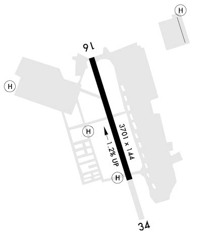 Airport Diagram might not be current. | |
| Facility Name: | YOAKUM-DEFRENN AHP |
| City Name: | FORT CAVAZOS (KILLEEN) |
| County: | BELL |
| State abbrev: | TX |
| State Name: | TEXAS |
| Ownership: | ARMY OWNED |
| Use: | PRIVATE |
| Owner's Name: | US ARMY |
| Address: | US ARMY AERONAUTICAL SVCS AGENCY, 9325 GUNSTON RD, STE N319 |
| FORT BELVOIR, VA 22060-5582 | |
| Owner's Phone: | |
| Manager's Name: | DIRECTORATE OF AVIATION OPERATIONS |
| Address: | BLDG 90029, CLARKE RD |
| FORT CAVAZOS, TX 76544 | |
| Phone: | 254-553-0501; AMGR; DIR OF AVN OPNS: 254-288-1424 |
| FAA Region: | SOUTHWEST |
| FAA Field Office: | TEX |
| Date | Sunrise | Sunset |
|---|---|---|
| 04/19/24 Friday | 6:58 | 20:02 |
| 04/20/24 Saturday | 6:57 | 20:03 |
| 04/21/24 Sunday | 6:55 | 20:04 |
| 04/22/24 Monday | 6:54 | 20:04 |
| 04/23/24 Tuesday | 6:53 | 20:05 |
| 04/24/24 Wednesday | 6:52 | 20:06 |
| 04/25/24 Thursday | 6:51 | 20:07 |
| 04/26/24 Friday | 6:50 | 20:07 |
| 04/27/24 Saturday | 6:49 | 20:08 |
| 04/28/24 Sunday | 6:48 | 20:09 |
| 04/29/24 Monday | 6:47 | 20:09 |
| 04/30/24 Tuesday | 6:46 | 20:10 |
| 05/01/24 Wednesday | 6:46 | 20:11 |
| 05/02/24 Thursday | 6:45 | 20:11 |
| Airport Attendance Schedule | MON-FRI 1400-0600Z++, EXC HOL |
| Airport Status | OPERATIONAL (This Status can change at any time - please check NOTAMS) |
| Airport Lighting Schedule | LGT-MIRL AHP 16-34 OPR 1400-0600++ WKD EXC FED HOL OT PCL 119.65. |
| Airport Storage Available | NONE |
| Extra Services Available | NONE |
| Wind Indicator | NONE |
| Control Tower | YES |
| CTAF Frequency | |
| Unicom Frequency | |
| Rotating Beacon Color | SWG |
| Segmented Circle | NO |
| Landing Fee |
| Airport Inspected | No Inspection Data Available performed by the OWNER |
| Inspection Date | Unknown |
| Type of Fuel Available | None |
| Airframe Repair Service | None |
| Power Plant Repair Service | None |
| Latitude | N3108.3 |
| Longitude | W09742.8 (ESTIMATED) |
| Arpt Elevation | 910ft (SURVEYED) |
| Magnetic Variation | 05E |
| 1 miles NE | of FORT CAVAZOS (KILLEEN) |
| Traffic Pattern Altitude | |
| Sectional Chart | SAN ANTONIO |
| Operations (Reported) | Yearly | Avg. Daily |
|---|---|---|
| General Aviation Transient | 0 | 0 |
| General Aviation Local | 0 | 0 |
| Air Taxi | 0 | 0 |
| Commerical | 0 | 0 |
| Commuter | 0 | 0 |
| Military | 0 | 0 |
| Aircraft based on Field | |
|---|---|
| General Aviation Singles | 0 |
| General Aviation Multi | 0 |
| Jet Aircraft | 0 |
| General Aviation Helicopters | 0 |
| Military Aircraft | 0 |
| Gliders | 0 |
| Ultralights | 0 |
| FSS on field | NO |
| FSS tie-in | SAN ANGELO |
| FSS Phone | 1-800-WX-BRIEF |
| Who issues Notams | SJT |
| Notam D service at airport | YES |
| ARTCC Name | HOUSTON |
| Airport Certification | |
| Aircraft Rescue & Firefighting Index | None |
| Airport of Entry | No |
| Custom Landing Rights | No |
| Joint Civil/Military | No |
| Military Landing rights | No |
| CAUTION: R6302 LCTD 1.1 NM N OF AFLD. |
| TRAN ALERT: LTD TRAN PRK. |
| RSTD: PPR ALL TRAN ACFT, C254-288-3811, DSN 738-3811 OR C254-287-7585 DSN 737-7585. RSTD FROM F/W ACFT. |
| MISC: NO TRML FCST ISSUED FOR YOAKUM-DEFRENN AHP. |
| SEE FLIP AP/1 SUPPLEMENTARY ARPT |
| CAUTION: SOME ACFT OPR IN AREA WO CONSPICUOUS MRK AND BLEND WITH TERRAIN. |
| TFC PAT: LEFT AND RGT TFC ALT 1500'. |
| SERVICE - FUEL - A++. RAPID REFUEL OPR TIMES BY NOTAM. |
| PMSV GRAY METRO: WX OBSN FULLY AUTOMATED. MANUAL BACK-UP PRVDD FOR EQUIPMENT/COMMUNICATION FAILURE ONLY DURING AFLD OPERATING HRS. |
| H-1 AND TWY J CLSD 1200-1330Z++ MON-FRI EXC HOL. |
| CAUTION - EXTSV UAS ACT WI CLASS D ASP AND BTN ROBERT GRAY AAF AND R6302. |
| CAUTION: INST FINAL APCH CRS CROSS 1 NM SW KILLEEN MUNI. |
| CAUTION: INTS COPTER OPR VCNTY FT CAVAZOS. |
| RSTD: NO BASE OPS SVC AVBL AT YOAKUM-DEFRENN AHP, CTC ROBERT GRAY BASE OPS C254-288-9200, DSN 738-9200. |
| OIL: SOAP. |
Airport Communications & Frequencies:
| |||||||||||||||||||||||||||||
| Runway: 16 | Runway: 34 | ||
| Mag heading: | N/A | Mag heading: | N/A |
| Rwy Slope: | -1.01% Down | Rwy Slope: | 1.01% Up |
| Approach: | Approach: | ||
| Pattern: | Left Traffic | Pattern: | Left Traffic |
| Markings: | BASIC | Markings: | BASIC |
| Marking Condition: | GOOD; 16 H | Marking Condition: | GOOD; 34 H |
| Arresting Dev: | Arresting Dev: | ||
| Lat & Long: | N3108.5 W09742.9 | Lat. & Long.: | N3108.0 W09742.8 |
| Elev: | 910.0 ft. MSL | Elev: | 883.1 ft. MSL |
| TCH: | TCH: | ||
| Visual Glide Path: | Visual Glide Path: | ||
| Displaced Threshold: | No | Displaced Threshold: | No |
| Touchdown Zone: | YES | Touchdown Zone: | YES |
| Touchdown Elev.: | 910.0 feet | Touchdown Elev.: | 910.0 feet |
| Visual Glide Slope: | Visual Glide Slope: | ||
| RVR Equipment: | ROLLOUT | RVR Equipment: | TOUCHDOWN |
| RVV Equipment: | NO | RVV Equipment: | NO |
| Approach Lights: | Approach Lights: | ||
| REIL: | NO | REIL: | NO |
| Centerline Lights: | NO | Centerline Lights: | NO |
| Touchdown lights: | NO | Touchdown lights: | NO |
| Runway Category: | Runway Category: | ||
| Declared Distances: | Declared Distances: |
