Current Weather/Notams (Metars, TAFs, Notams, NWS Forecast, PIREPS, and nearby weather)
Customs Information Send updates to Support@FltPlan.com
Customs Not Available
Database effective 04/18/2024
Airport Diagram might not be current.
|
| Facility Name: | WHEELING OHIO COUNTY |
| City Name: | WHEELING |
| County: | OHIO |
| State abbrev: | WV |
| State Name: | WEST VIRGINIA |
| | |
| Ownership: | PUBLICLY OWNED |
| Use: | OPEN TO THE PUBLIC |
| Owner's Name: | OHIO CO COMSN |
| Address: | 1500 CHAPLINE ST |
| | WHEELING, WV 26003 |
| Owner's Phone: | 304-234-3628 |
| | |
| Manager's Name: | RUSSEL W. ESCUE |
| Address: | 115 SKYWAY LANE |
| | WHEELING, WV 26003 |
| Phone: | 304-234-3865 |
| | |
| FAA Region: | EASTERN |
| FAA Field Office: | BKW |
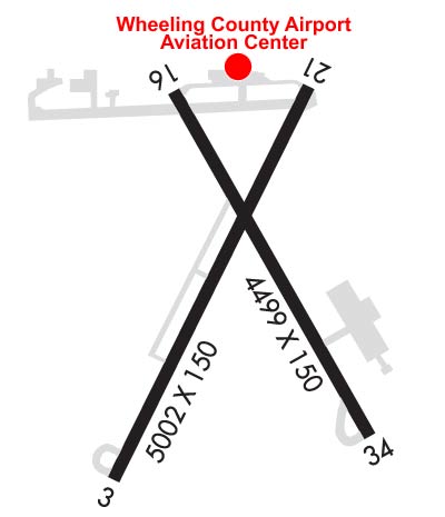
Runway Identifications
Runway Identification: 03/21Length: 5002 ft
Width: 150 ft
Surface: ASPHALT-FAIR CONDITION
Edge lights: High IntensityTreatment: GROOVED
| | Runway: 03 | | Runway: 21 |
| Mag heading: | 33° | Mag heading: | 213° |
| Rwy Slope: | .49% Up | Rwy Slope: | -.49% Down |
| Approach: | ILS | Approach: | |
| Pattern: | Left Traffic | Pattern: | Left Traffic |
| Markings: | PRECISION INSTRUMENT | Markings: | PRECISION INSTRUMENT |
| Marking Condition: | FAIR | Marking Condition: | FAIR |
| Arresting Dev: | | Arresting Dev: | |
| Lat & Long: | N4010.1 W08039.1 | Lat. & Long.: | N4010.9 W08038.6 |
| Elev: | 1170.0 ft. MSL | Elev: | 1194.3 ft. MSL |
| TCH: | | TCH: | 42 ft. AGL |
| Visual Glide Path: | | Visual Glide Path: | 3.00 degrees |
| Displaced Threshold: | No | Displaced Threshold: | No |
| Touchdown Zone: | YES | Touchdown Zone: | YES |
| Touchdown Elev.: | 1171.6 feet | Touchdown Elev.: | 1194.3 feet |
| Visual Glide Slope: | | Visual Glide Slope: | 2-Box VASI on LEFT side of Runway; UNUSBL BYD 8 DEGS LEFT OF CNTRLN. |
| RVR Equipment: | TOUCHDOWN-ROLLOUT | RVR Equipment: | TOUCHDOWN-ROLLOUT |
| RVV Equipment: | YES | RVV Equipment: | NO |
| Approach Lights: | MALSF - 1,400 foot medium intensity approach lighting system with sequenced flashers | Approach Lights: | |
| REIL: | NO | REIL: | YES |
| Centerline Lights: | NO | Centerline Lights: | NO |
| Touchdown lights: | NO | Touchdown lights: | NO |
| Runway Category: | Precision Instrument Runway | Runway Category: | Runway with a Non-precision Approach having visibility minimums greater than 3/4 mile |
| Declared Distances: | | Declared Distances: | |
| Obstructions: | TREES | Obstructions: | TREES |
| Marked: | NOT Marked/Lighted | Marked: | NOT Marked/Lighted |
| Clearance slope: | 1:1; RWY 03 ACTUAL OBSTN CLNC SLOPE 0:1. | Clearance slope: | 2:1 |
| Obstruction height: | 26 feet AGL | Obstruction height: | 16 feet AGL |
| Dist. from runway: | 201 feet | Dist. from runway: | 236 feet |
| Centerline offset: | 495 left of centerline | Centerline offset: | 350 feet right of centerline |
| Comments: | 15 FT BRUSH, 0-199 FT DSTC, 370 FT L, 260 FT R. | Comments: | 10 FT BUILDING 150 FT DSTC, 250 FT R; 6 FT FENCE, 0-200 FT DSTC, 0-500 FT R/L; 10 FT BRUSH, 150 FT DSTC, 250 FT R/L. |
Runway Identification: 16/34Length: 4499 ft
Width: 150 ft
Surface: ASPHALT-FAIR CONDITION
Edge lights: Medium IntensityTreatment: NONE
| | Runway: 16 | | Runway: 34 |
| Mag heading: | 158° | Mag heading: | 338° |
| Rwy Slope: | .44% Up | Rwy Slope: | -.44% Down |
| Approach: | | Approach: | |
| Pattern: | Left Traffic | Pattern: | Left Traffic |
| Markings: | NONPRECISION INSTRUMENT | Markings: | NONPRECISION INSTRUMENT |
| Marking Condition: | FAIR | Marking Condition: | FAIR |
| Arresting Dev: | | Arresting Dev: | |
| Lat & Long: | N4010.8 W08038.9 | Lat. & Long.: | N4010.2 W08038.5 |
| Elev: | 1171.4 ft. MSL | Elev: | 1191.0 ft. MSL |
| TCH: | | TCH: | 42 ft. AGL |
| Visual Glide Path: | | Visual Glide Path: | 3.00 degrees |
| Displaced Threshold: | No | Displaced Threshold: | No |
| Touchdown Zone: | YES | Touchdown Zone: | YES |
| Touchdown Elev.: | 1177.6 feet | Touchdown Elev.: | 1191.0 feet |
| Visual Glide Slope: | | Visual Glide Slope: | 4-Light PAPI on LEFT side of Runway; PAPI OTS INDEFLY. |
| RVR Equipment: | | RVR Equipment: | |
| RVV Equipment: | NO | RVV Equipment: | NO |
| Approach Lights: | | Approach Lights: | |
| REIL: | NO | REIL: | YES; REIL OTS INDFLY. |
| Centerline Lights: | NO | Centerline Lights: | NO |
| Touchdown lights: | NO | Touchdown lights: | NO |
| Runway Category: | Runway with a Non-precision Approach having visibility minimums greater than 3/4 mile | Runway Category: | Runway with a Non-precision Approach having visibility minimums greater than 3/4 mile |
| Declared Distances: | | Declared Distances: | |
| Obstructions: | TREES | Obstructions: | TREES |
| Marked: | NOT Marked/Lighted | Marked: | NOT Marked/Lighted |
| Clearance slope: | 35:1 | Clearance slope: | 15:1 |
| Obstruction height: | 19 feet AGL | Obstruction height: | 17 feet AGL |
| Dist. from runway: | 877 feet | Dist. from runway: | 468 feet |
| Centerline offset: | 85 left of centerline | Centerline offset: | 240 feet right of centerline |
| Comments: | | Comments: | |