Click here for more info on on SMS!

KHLB

HILLENBRAND INDUSTRIES
BATESVILLE
IN
Time Zone: Eastern
Lat: N 3920.6
Long: W 08515.5
Elev: 975
Var: +05
Longest Runway: 5933
CTAF: 122.72

FBO & Flight Services info for KHLB

FBOs: Update your Fuel Prices

BATESVILLE AV SVCPh: 812-934-7593
-
Freq: 122.72
Service
Jet
100LL
SAF
MoGas
Fuel Avail: Self serve only if unattended.
Full        Caution: Fuel prices have not been updated in 39 days.
Last Update: 03/15/2024 10:40

Self6.28      
If you are an FBO, call 1-203-262-1700 to update your info or email: FltPlan.Advertising@garmin.com
Advertise your FBO on FltPlan.com

Runway & Approach Info for KHLB
Rwy
Length
Land Dist**
Approach*
  Rwy
Length
Land Dist**
Approach*
18
5933x100  5354'          
 
  
36
  5933x100  5933'          
 
 * only ILS, LOC, LDA, and SDF approaches to a specific runway are shown
** For any Declared Landing Distance Available, please see A/FD or Approach plates
Runway Weight Capability (lbs.) Help
Runway IDSingle WheelDouble WheelDouble Tandem WheelDual Double Wheel
18/36N/AN/AN/AN/A
These numbers are Advisory and are not limits.   The Airport Manager should have more accurate Weight Limits
Approach Charts
FltPlan does not have IFR approach charts available for KHLB.
Current Weather/Notams
Customs Information Send updates to Support@FltPlan.com
Customs Not Available
Database effective 05/16/2024
Facility Name: BATESVILLE
City Name: BATESVILLE
County: FRANKLIN
State abbrev: IN
State Name: INDIANA
   
Ownership: PRIVATELY OWNED
Use: OPEN TO THE PUBLIC
Owner's Name: EAST WEST HELICOPTER, INC.
Address: 25222 ENOCHSBURG RD.
 BATESVILLE, IN 47006
Owner's Phone: 812-934-7593
  
Manager's Name: PATRIC WELLS
Address: 25222 ENOCHSBURG RD.
 BATESEVILLE, IN 47006
Phone: 812-934-7593
   
FAA Region: GREAT LAKES
FAA Field Office: CHI


Sunrise / Sunset times for BATESVILLE

DateSunriseSunset
04/22/24 Monday6:5320:26
04/23/24 Tuesday6:5220:27
04/24/24 Wednesday6:5020:28
04/25/24 Thursday6:4920:29
04/26/24 Friday6:4820:30
04/27/24 Saturday6:4620:31
04/28/24 Sunday6:4520:32
04/29/24 Monday6:4420:33
04/30/24 Tuesday6:4320:34
05/01/24 Wednesday6:4120:35
05/02/24 Thursday6:4020:36
05/03/24 Friday6:3920:37
05/04/24 Saturday6:3820:38
05/05/24 Sunday6:3720:39

Airport Facilities

Airport Attendance ScheduleMON-FRI 0800-1700 LOCAL
Airport Status OPERATIONAL (This Status can change at any time - please check NOTAMS)
Airport Lighting ScheduleACTVT HIRL RWY 18/36 - CTAF.
Airport Storage AvailableTie Downs, Hanger
Extra Services AvailableNONE
Wind IndicatorYES - (unlit)
Control TowerNO
CTAF Frequency122.725
Unicom Frequency122.725
Rotating Beacon ColorWG
Segmented CircleNO
Landing FeeNO

Airport Inspection Data

Airport Inspected5010-2 PRIVATE USE MAILOUT PROGRAM - performed by STATE AERONAUTICAL PERSONNEL
Inspection Date07/19/2022

Airport Services

Type of Fuel AvailableJET A (freeze point -40C)
Airframe Repair ServiceMAJOR
Power Plant Repair ServiceMINOR

Geographic Data

LatitudeN3920.6
LongitudeW08515.5 (ESTIMATED)
Arpt Elevation975ft (SURVEYED)
Magnetic Variation05W
3 miles NWof BATESVILLE
Traffic Pattern Altitude
Sectional ChartST LOUIS

Aircraft Data

Operations (Reported)YearlyAvg. Daily
General Aviation Transient 7612
General Aviation Local 11593
Air Taxi 00
Commerical 00
Commuter 00
Military 2571
Aircraft based on Field
General Aviation Singles 1
General Aviation Multi 0
Jet Aircraft 0
General Aviation Helicopters 1
Military Aircraft 0
Gliders 0
Ultralights 0

FAA Services

FSS on field NO
FSS tie-in TERRE HAUTE
FSS Phone 1-800-WX-BRIEF
Who issues Notams HUF
Notam D service at airport No
ARTCC Name INDIANAPOLIS

Federal Status

Airport Certification
Aircraft Rescue & Firefighting IndexNone
Airport of EntryNo
Custom Landing RightsNo
Joint Civil/MilitaryNo
Military Landing rightsNo

Remarks

FOR CD CTC CINCINNATI APCH AT 859-372-6440
Airport Communications & Frequencies:
CTAF Frequency:
122.725
Unicom Frequency:
122.725
CINCINNATI Primary Approach Frequencies:  
128.7
254.25
CINCINNATI Primary Departure Frequencies:  
128.7
254.25
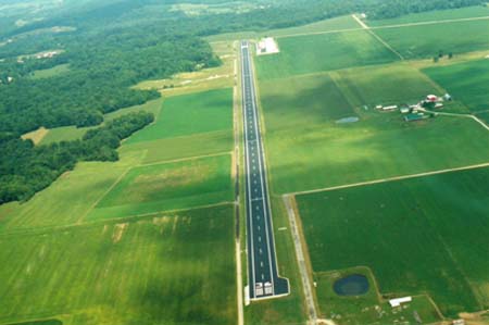
Runway Identifications
Runway Identification: 18/36
Length: 5933 ft
Width: 100 ft
Surface: ASPHALT
Edge lights: High Intensity

Treatment: NONE

 Runway: 18   Runway: 36
Mag heading: N/AMag heading: N/A
Rwy Slope: -.01% DownRwy Slope: .01% Up
Approach: Approach:
Pattern: Left TrafficPattern: Left Traffic
Markings: Markings:
Marking Condition: Marking Condition:
Arresting Dev: Arresting Dev:
Lat & Long: N3921.1  W08515.5Lat. & Long.: N3920.1  W08515.5
Elev: 975.0 ft. MSLElev: 974.6 ft. MSL
TCH: TCH: 30 ft. AGL
Visual Glide Path: Visual Glide Path: 3.00 degrees
Displaced Threshold: 579 feetDisplaced Threshold: No
Touchdown Zone: YESTouchdown Zone: YES
Touchdown Elev.: 974.9 feetTouchdown Elev.: 974.9 feet
Visual Glide Slope: Visual Glide Slope: 2-Light PAPI on RIGHT side of Runway
RVR Equipment: RVR Equipment:
RVV Equipment: NORVV Equipment: NO
Approach Lights: Approach Lights:
REIL: YESREIL: YES
Centerline Lights: NOCenterline Lights: NO
Touchdown lights: NOTouchdown lights: NO
Runway Category: Runway with a Visual ApproachRunway Category: Runway with a Visual Approach
Declared Distances: Declared Distances:
Obstructions: TREESObstructions: TREE
Marked: NOT Marked/LightedMarked: NOT Marked/Lighted
Clearance slope: 5:1; APCH RATIO 17:1 TO DTHR.Clearance slope: 1:1
Obstruction height: 67 feet AGLObstruction height: 27 feet AGL
Dist. from runway: 600 feetDist. from runway: 250 feet
Centerline offset: 65 left of centerlineCenterline offset: 160 feet right of centerline
Comments: BLAST FENCE 10 FT FM RWY END; ROAD 25 FT FM RWY END; CROPS 60 FT FM RWY END.Comments:
C:4/P: