Current Weather/Notams (Metars, TAFs, Notams, NWS Forecast, PIREPS, and nearby weather)
Customs Information Send updates to Support@FltPlan.com
Customs Not Available
Database effective 04/18/2024
Airport Diagram might not be current.
|
| Facility Name: | HEMPHILL COUNTY |
| City Name: | CANADIAN |
| County: | HEMPHILL |
| State abbrev: | TX |
| State Name: | TEXAS |
| | |
| Ownership: | PUBLICLY OWNED |
| Use: | OPEN TO THE PUBLIC |
| Owner's Name: | HEMPHILL COUNTY |
| Address: | 400 MAIN STREET, SUITE 200 |
| | CANADIAN, TX 79014 |
| Owner's Phone: | 806-323-6521; COUNTY COURTHOUSE |
| | |
| Manager's Name: | BILL KENDALL |
| Address: | 255 AIRPORT ROAD - PO BOX 96 |
| | CANADIAN, TX 79014 |
| Phone: | (806) 679-4774; 24 HR CONTACT 806-679-4774 |
| | |
| FAA Region: | SOUTHWEST |
| FAA Field Office: | TEX |
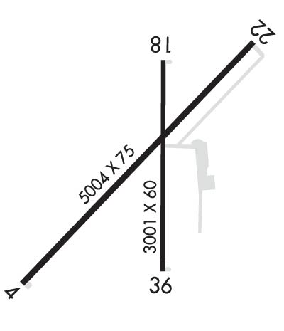
Runway Identifications
Runway Identification: 04/22Length: 5004 ft
Width: 75 ft
Surface: ASPHALT
Edge lights: Medium IntensityTreatment: NONE
| | Runway: 04 | | Runway: 22 |
| Mag heading: | 38° | Mag heading: | 218° |
| Rwy Slope: | -.24% Down | Rwy Slope: | .24% Up |
| Approach: | | Approach: | |
| Pattern: | Left Traffic | Pattern: | Right Traffic |
| Markings: | NONPRECISION INSTRUMENT | Markings: | NONPRECISION INSTRUMENT |
| Marking Condition: | GOOD | Marking Condition: | GOOD |
| Arresting Dev: | | Arresting Dev: | |
| Lat & Long: | N3553.4 W10024.6 | Lat. & Long.: | N3554.0 W10023.9 |
| Elev: | 2387.4 ft. MSL | Elev: | 2375.6 ft. MSL |
| TCH: | 38 ft. AGL | TCH: | 35 ft. AGL |
| Visual Glide Path: | 3.00 degrees | Visual Glide Path: | 3.00 degrees |
| Displaced Threshold: | No | Displaced Threshold: | No |
| Touchdown Zone: | YES | Touchdown Zone: | YES |
| Touchdown Elev.: | 2387.0 feet | Touchdown Elev.: | 2381.5 feet |
| Visual Glide Slope: | 2-Light PAPI on LEFT side of Runway | Visual Glide Slope: | 2-Light PAPI on LEFT side of Runway |
| RVR Equipment: | | RVR Equipment: | |
| RVV Equipment: | NO | RVV Equipment: | NO |
| Approach Lights: | | Approach Lights: | |
| REIL: | YES | REIL: | YES |
| Centerline Lights: | NO | Centerline Lights: | NO |
| Touchdown lights: | NO | Touchdown lights: | NO |
| Runway Category: | Runway with a Non-precision Approach having visibility minimums greater than 3/4 mile | Runway Category: | Runway with a Non-precision Approach having visibility minimums greater than 3/4 mile |
| Declared Distances: | | Declared Distances: | |
| Obstructions: | FENCE | Obstructions: | TREES |
| Marked: | NOT Marked/Lighted | Marked: | NOT Marked/Lighted |
| Clearance slope: | 23:1 | Clearance slope: | 26:1 |
| Obstruction height: | 8 feet AGL | Obstruction height: | 46 feet AGL |
| Dist. from runway: | 390 feet | Dist. from runway: | 1417 feet |
| Centerline offset: | | Centerline offset: | |
| Comments: | | Comments: | |
Runway Identification: 18/36Length: 3001 ft
Width: 60 ft
Surface: ASPHALT
Edge lights: Medium IntensityTreatment: NONE
| | Runway: 18 | | Runway: 36 |
| Mag heading: | 179° | Mag heading: | 359° |
| Rwy Slope: | .96% Up | Rwy Slope: | -.96% Down |
| Approach: | | Approach: | |
| Pattern: | Right Traffic | Pattern: | Left Traffic |
| Markings: | BASIC | Markings: | BASIC |
| Marking Condition: | GOOD | Marking Condition: | GOOD |
| Arresting Dev: | | Arresting Dev: | |
| Lat & Long: | N3554.0 W10024.2 | Lat. & Long.: | N3553.5 W10024.2 |
| Elev: | 2367.6 ft. MSL | Elev: | 2396.4 ft. MSL |
| TCH: | | TCH: | |
| Visual Glide Path: | | Visual Glide Path: | |
| Displaced Threshold: | 100 feet | Displaced Threshold: | No |
| Touchdown Zone: | YES | Touchdown Zone: | YES |
| Touchdown Elev.: | 2396.4 feet | Touchdown Elev.: | 2396.4 feet |
| Visual Glide Slope: | | Visual Glide Slope: | |
| RVR Equipment: | | RVR Equipment: | |
| RVV Equipment: | NO | RVV Equipment: | NO |
| Approach Lights: | | Approach Lights: | |
| REIL: | NO | REIL: | NO |
| Centerline Lights: | NO | Centerline Lights: | NO |
| Touchdown lights: | NO | Touchdown lights: | NO |
| Runway Category: | Runway with a Visual Approach | Runway Category: | Runway with a Visual Approach |
| Declared Distances: | | Declared Distances: | |
| Obstructions: | ROAD | Obstructions: | FENCE |
| Marked: | NOT Marked/Lighted | Marked: | NOT Marked/Lighted |
| Clearance slope: | 1:1; APCH SLOPE 31:1 AT DSPLCD THR. | Clearance slope: | 2:1 |
| Obstruction height: | 10 feet AGL | Obstruction height: | 6 feet AGL |
| Dist. from runway: | 210 feet | Dist. from runway: | 212 feet |
| Centerline offset: | 126 right of centerline | Centerline offset: | |
| Comments: | | Comments: | |

