Current Weather/Notams (Metars, TAFs, Notams, NWS Forecast, PIREPS, and nearby weather)
Customs Information Send updates to Support@FltPlan.com
Customs Not Available
Database effective 05/16/2024
Airport Diagram might not be current.
|
| Facility Name: | HARDY-ANDERS FLD/NATCHEZ-ADAMS COUNTY |
| City Name: | NATCHEZ |
| County: | ADAMS |
| State abbrev: | MS |
| State Name: | MISSISSIPPI |
| | |
| Ownership: | PUBLICLY OWNED |
| Use: | OPEN TO THE PUBLIC |
| Owner's Name: | ADAMS COUNTY |
| Address: | BOX 1008 |
| | NATCHEZ, MS 39121 |
| Owner's Phone: | 601-442-2431 |
| | |
| Manager's Name: | RICHARD NELSON |
| Address: | 434 AIRPORT RD |
| | NATCHEZ, MS 39120 |
| Phone: | 601-442-5171 |
| | |
| FAA Region: | SOUTHERN |
| FAA Field Office: | JAN |
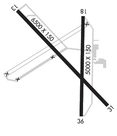
Runway Identifications
Runway Identification: 14/32Length: 6500 ft
Width: 150 ft
Surface: ASPHALT
Edge lights: High IntensityTreatment: GROOVED
Weight: PCN 39 /F/B/Y/T
| | Runway: 14 | | Runway: 32 |
| Mag heading: | 136° | Mag heading: | 316° |
| Rwy Slope: | .12% Up | Rwy Slope: | -.12% Down |
| Approach: | ILS | Approach: | |
| Pattern: | Left Traffic | Pattern: | Left Traffic |
| Markings: | PRECISION INSTRUMENT | Markings: | NONPRECISION INSTRUMENT |
| Marking Condition: | GOOD | Marking Condition: | GOOD |
| Arresting Dev: | | Arresting Dev: | |
| Lat & Long: | N3137.2 W09118.4 | Lat. & Long.: | N3136.5 W09117.5 |
| Elev: | 261.5 ft. MSL | Elev: | 269.3 ft. MSL |
| TCH: | 55 ft. AGL | TCH: | 43 ft. AGL |
| Visual Glide Path: | 3.00 degrees | Visual Glide Path: | 3.00 degrees |
| Displaced Threshold: | No | Displaced Threshold: | No |
| Touchdown Zone: | YES | Touchdown Zone: | YES |
| Touchdown Elev.: | 266.1 feet | Touchdown Elev.: | 272.3 feet |
| Visual Glide Slope: | 4-Light PAPI on RIGHT side of Runway | Visual Glide Slope: | 4-Light PAPI on LEFT side of Runway |
| RVR Equipment: | | RVR Equipment: | |
| RVV Equipment: | NO | RVV Equipment: | NO |
| Approach Lights: | MALSR - 1,400 foot medium intensity approach lighting system with runway alignment indicator lights | Approach Lights: | |
| REIL: | NO | REIL: | NO |
| Centerline Lights: | NO | Centerline Lights: | NO |
| Touchdown lights: | NO | Touchdown lights: | NO |
| Runway Category: | Precision Instrument Runway | Runway Category: | Runway with a Non-precision Approach having visibility minimums greater than 3/4 mile |
| Declared Distances: | | Declared Distances: | |
| Obstructions: | | Obstructions: | TREES |
| Marked: | | Marked: | NOT Marked/Lighted |
| Clearance slope: | 50:1 | Clearance slope: | 28:1 |
| Obstruction height: | | Obstruction height: | 78 feet AGL |
| Dist. from runway: | | Dist. from runway: | 2400 feet |
| Centerline offset: | | Centerline offset: | 250B |
| Comments: | | Comments: | |
Runway Identification: 18/36Length: 5000 ft
Width: 150 ft
Surface: ASPHALT-POOR CONDITION
Edge lights: Medium IntensityTreatment: NONE
Weight: PCN 35 /F/B/Y/T
| | Runway: 18 | | Runway: 36 |
| Mag heading: | 181° | Mag heading: | 1° |
| Rwy Slope: | -.18% Down | Rwy Slope: | .18% Up |
| Approach: | | Approach: | |
| Pattern: | Left Traffic | Pattern: | Left Traffic |
| Markings: | NONPRECISION INSTRUMENT | Markings: | NONPRECISION INSTRUMENT |
| Marking Condition: | POOR; MARKINGS FADED. | Marking Condition: | POOR; MARKINGS FADED. |
| Arresting Dev: | | Arresting Dev: | |
| Lat & Long: | N3137.2 W09117.7 | Lat. & Long.: | N3136.4 W09117.7 |
| Elev: | 269.4 ft. MSL | Elev: | 260.2 ft. MSL |
| TCH: | 30 ft. AGL | TCH: | |
| Visual Glide Path: | 3.00 degrees | Visual Glide Path: | |
| Displaced Threshold: | No | Displaced Threshold: | No |
| Touchdown Zone: | YES | Touchdown Zone: | YES |
| Touchdown Elev.: | 271.6 feet | Touchdown Elev.: | 272.4 feet |
| Visual Glide Slope: | 4-BOX VASI ON LEFT SIDE OF RUNWAY | Visual Glide Slope: | |
| RVR Equipment: | | RVR Equipment: | |
| RVV Equipment: | NO | RVV Equipment: | NO |
| Approach Lights: | | Approach Lights: | |
| REIL: | NO | REIL: | NO |
| Centerline Lights: | NO | Centerline Lights: | NO |
| Touchdown lights: | NO | Touchdown lights: | NO |
| Runway Category: | Runway with a Non-precision Approach having visibility minimums greater than 3/4 mile | Runway Category: | Runway with a Non-precision Approach having visibility minimums greater than 3/4 mile |
| Declared Distances: | | Declared Distances: | |
| Obstructions: | | Obstructions: | TREES |
| Marked: | | Marked: | NOT Marked/Lighted |
| Clearance slope: | 50:1 | Clearance slope: | 19:1 |
| Obstruction height: | | Obstruction height: | 63 feet AGL |
| Dist. from runway: | | Dist. from runway: | 1400 feet |
| Centerline offset: | | Centerline offset: | 300 feet right of centerline |
| Comments: | | Comments: | |

