Click here for more info on on SMS!

KHEE

THOMPSON-ROBBINS
HELENA/WEST HELENA
AR
Time Zone: Central
Lat: N 3434.6
Long: W 09040.6
Elev: 242
Var: -01
Longest Runway: 5001
CTAF: 122.8

FBO & Flight Services info for KHEE

FBOs: Update your Fuel Prices
We are a full service, first-class FBO with a commitment to the best possible client experience available. We offer full service Jet A fuel and 100 LL. Our newly constructed facility includes a number of top amenities for both quick turn services and long-term needs. Whether it's ground transportation, maintenance & repair or pilot supplies, we go the extra mile to exceed your expectations.
Ph: 870-572-9011 Fax: 870-572-6005 Freq: 122.8WebsiteE-Mail
                   
Service
Jet
100LL
SAF
MoGas
Fuel Avail: JETA INCLUDES PRIST. 8 am to 5pm
Full5.806.20    Last Update: 03/26/2024 08:42

Self        
Misc. Info: Address: 230 PHILLIPS 204 RD   W HELENA, AR 72390

If you are an FBO, call 1-203-262-1700 to update your info or email: FltPlan.Advertising@garmin.com
Advertise your FBO on FltPlan.com

Runway & Approach Info for KHEE
Rwy
Length
Land Dist**
Approach*
  Rwy
Length
Land Dist**
Approach*
09
3011x60  3011'          
 
  
27
  3011x60  3011'          
 
18
5001x100  5001'          
 
  
36
  5001x100  5001'          
 
 * only ILS, LOC, LDA, and SDF approaches to a specific runway are shown
** For any Declared Landing Distance Available, please see A/FD or Approach plates
Runway Weight Capability (lbs.) Help
Runway IDSingle WheelDouble WheelDouble Tandem WheelDual Double Wheel
09/2716,000N/AN/AN/A
18/3615,000N/AN/AN/A
These numbers are Advisory and are not limits.   The Airport Manager should have more accurate Weight Limits
Approach Charts
Approaches    
Current Weather/Notams
Customs Information Send updates to Support@FltPlan.com
Customs Not Available
Database effective 05/16/2024
Airport Diagram of KHEE
Airport Diagram might not be current.

Facility Name: THOMPSON-ROBBINS
City Name: HELENA/WEST HELENA
County: PHILLIPS
State abbrev: AR
State Name: ARKANSAS
   
Ownership: PUBLICLY OWNED
Use: OPEN TO THE PUBLIC
Owner's Name: HELENA WEST HELENA
Address: CITY OF HELENA / WEST HELENA, 226 PERRY STR
 HELENA, AR 72342
Owner's Phone: (870) 817-7400
  
Manager's Name: BILL BROTHERS
Address: PO BOX 2948
 WEST HELENA, AR 72390
Phone: 870-714-1844
   
FAA Region: SOUTHWEST
FAA Field Office: AOK


Sunrise / Sunset times for THOMPSON-ROBBINS

DateSunriseSunset
04/22/24 Monday6:2219:41
04/23/24 Tuesday6:2119:42
04/24/24 Wednesday6:1919:43
04/25/24 Thursday6:1819:43
04/26/24 Friday6:1719:44
04/27/24 Saturday6:1619:45
04/28/24 Sunday6:1519:46
04/29/24 Monday6:1419:47
04/30/24 Tuesday6:1319:47
05/01/24 Wednesday6:1219:48
05/02/24 Thursday6:1119:49
05/03/24 Friday6:1019:50
05/04/24 Saturday6:0919:50
05/05/24 Sunday6:0819:51

Airport Facilities

Airport Attendance ScheduleMON-FRI DALGT, SAT 0800-1200
Airport Status OPERATIONAL (This Status can change at any time - please check NOTAMS)
Airport Lighting ScheduleACTVT MIRL RWY 09/27 & 18/36 - CTAF. PAPI RWY 18 & 36 ON CONSLY.
Airport Storage AvailableTie Downs, Hanger
Extra Services AvailableCrop Dusting, Flight Instruction, Aircraft Sales
Wind IndicatorYES - (lighted)
Control TowerNO
CTAF Frequency122.800
Unicom Frequency122.800
Rotating Beacon ColorWG
Segmented CircleYES
Landing FeeNO

Airport Inspection Data

Airport InspectedSTATE - performed by STATE AERONAUTICAL PERSONNEL
Inspection Date03/12/2024

Airport Services

Type of Fuel AvailableGrade 100LL, JET A (freeze point -40C)
Airframe Repair ServiceMAJOR
Power Plant Repair ServiceMAJOR

Geographic Data

LatitudeN3434.6
LongitudeW09040.6 (ESTIMATED)
Arpt Elevation241ft (SURVEYED)
Magnetic Variation01E
5 miles NWof HELENA/WEST HELENA
Traffic Pattern Altitude960
Sectional ChartMEMPHIS

Aircraft Data

Operations (Reported)YearlyAvg. Daily
General Aviation Transient 350010
General Aviation Local 3050084
Air Taxi 5001
Commerical 00
Commuter 00
Military 5001
Aircraft based on Field
General Aviation Singles 14
General Aviation Multi 1
Jet Aircraft 0
General Aviation Helicopters 0
Military Aircraft 0
Gliders 0
Ultralights 0

FAA Services

FSS on field NO
FSS tie-in JONESBORO
FSS Phone 1-800-WX-BRIEF
Who issues Notams JBR
Notam D service at airport YES
ARTCC Name MEMPHIS

Federal Status

Airport Certification
Aircraft Rescue & Firefighting IndexNone
Airport of EntryNo
Custom Landing RightsNo
Joint Civil/MilitaryNo
Military Landing rightsYES

Federal Agreements

NATIONAL PLAN OF INTEGRATED AIRPORT SYSTEMS (NPIAS)
GRANT AGREEMENTS UNDER FAAP/ADAP/AIP
SURPLUS PROPERTY AGREEMENT UNDER REGULATION 16-WAA
ASSURANCES PURSUANT TO TITLE VI, CIVIL RIGHTS ACT OF 1964
AGREEMENT UNDER DLAND OR DCLA HAS EXPIRED.

Remarks

(E81) TWY EXIT & GUIDANCE SIGNS.
NUMEROUS AGRICULTURE OPS FEB THRU OCT.
FOR CD CTC MEMPHIS ARTCC AT 901-368-8453/8449.
Airport Communications & Frequencies:
CTAF Frequency:
122.800
Unicom Frequency:
122.800
Remarks
  • APCH/DEP SVC PRVDD BY MEMPHIS ARTCC ON FREQS 135.3/335.8(BRINKLEY RCAG).
  • Runway Identifications
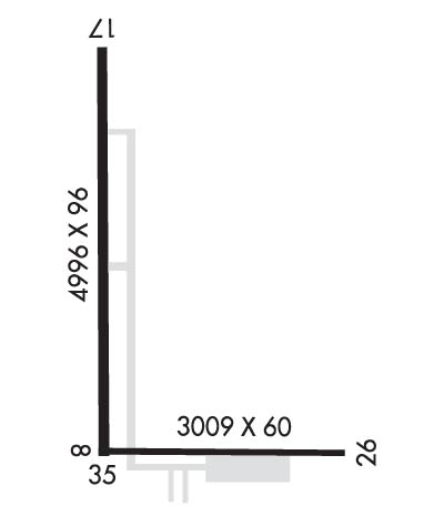
    Runway Identification: 09/27
    Length: 3011 ft
    Width: 60 ft
    Surface: ASPHALT-FAIR CONDITION
    Edge lights: Medium Intensity

    Treatment: NONE

     Runway: 09   Runway: 27
    Mag heading: 89°Mag heading: 269°
    Rwy Slope: .15% UpRwy Slope: -.15% Down
    Approach: Approach:
    Pattern: Left TrafficPattern: Left Traffic
    Markings: BASICMarkings: BASIC
    Marking Condition: GOODMarking Condition: GOOD
    Arresting Dev: Arresting Dev:
    Lat & Long: N3434.3  W09040.7Lat. & Long.: N3434.3  W09040.1
    Elev: 237.1 ft. MSLElev: 241.7 ft. MSL
    TCH: TCH:
    Visual Glide Path: Visual Glide Path:
    Displaced Threshold: NoDisplaced Threshold: No
    Touchdown Zone: YESTouchdown Zone: YES
    Touchdown Elev.: 241.7 feetTouchdown Elev.: 241.7 feet
    Visual Glide Slope: Visual Glide Slope:
    RVR Equipment: RVR Equipment:
    RVV Equipment: NORVV Equipment: NO
    Approach Lights: Approach Lights:
    REIL: NOREIL: NO
    Centerline Lights: NOCenterline Lights: NO
    Touchdown lights: NOTouchdown lights: NO
    Runway Category: Runway with a Visual ApproachRunway Category: Runway with a Visual Approach
    Declared Distances: Declared Distances:
    Obstructions: TREEObstructions:
    Marked: NOT Marked/LightedMarked:
    Clearance slope: 20:1Clearance slope: 50:1
    Obstruction height: 25 feet AGLObstruction height:
    Dist. from runway: 725 feetDist. from runway:
    Centerline offset: 115 right of centerlineCenterline offset:
    Comments: Comments:
    Runway Identification: 18/36
    Length: 5001 ft
    Width: 100 ft
    Surface: ASPHALT-GOOD CONDITION
    Edge lights: Medium Intensity

    Treatment: GROOVED

     Runway: 18   Runway: 36
    Mag heading: 179°Mag heading: 359°
    Rwy Slope: -.07% DownRwy Slope: .07% Up
    Approach: Approach:
    Pattern: Left TrafficPattern: Left Traffic
    Markings: NONPRECISION INSTRUMENTMarkings: NONPRECISION INSTRUMENT
    Marking Condition: GOODMarking Condition: GOOD
    Arresting Dev: Arresting Dev:
    Lat & Long: N3435.2  W09040.7Lat. & Long.: N3434.3  W09040.7
    Elev: 241.0 ft. MSLElev: 237.6 ft. MSL
    TCH: 48 ft. AGLTCH: 48 ft. AGL
    Visual Glide Path: 3.00 degreesVisual Glide Path: 3.00 degrees
    Displaced Threshold: NoDisplaced Threshold: No
    Touchdown Zone: YESTouchdown Zone: YES
    Touchdown Elev.: 241.0 feetTouchdown Elev.: 240.2 feet
    Visual Glide Slope: 4-Light PAPI on LEFT side of RunwayVisual Glide Slope: 4-Light PAPI on LEFT side of Runway
    RVR Equipment: RVR Equipment:
    RVV Equipment: NORVV Equipment: NO
    Approach Lights: Approach Lights:
    REIL: YESREIL: YES
    Centerline Lights: NOCenterline Lights: NO
    Touchdown lights: NOTouchdown lights: NO
    Runway Category: Runway with a Non-precision Approach having visibility minimums greater than 3/4 mileRunway Category: Runway with a Non-precision Approach having visibility minimums greater than 3/4 mile
    Declared Distances: Declared Distances:
    C:2/P: